TD ex-0706 Pabuk

Moderator: S2k Moderators

Message
Author
User avatar
Windspeed
Tropical Storm
Tropical Storm
Posts: 129
Joined: Thu Jun 10, 2004 11:38 am

Re: WPAC: 0706 TS Pabuk

#21 Postby Windspeed » Sun Aug 05, 2007 3:37 pm

HURAKAN wrote:
El Nino wrote:Pressure is quite deep for such intensity. I thought 990 would equal as a borderline hurricane.


That's in the Atlantic. By the way, Wilma had a pressure of 989 mb while a 50 mph storm.

Also, at that intensity, Wilma was embedded in a surface trough that made background surface pressure around 8mb below average.


Just a few comments on Pabuk:

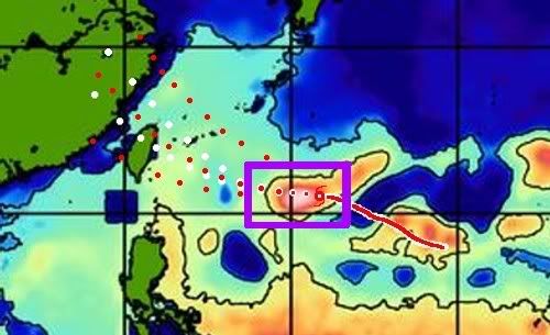
In the image below I sketched a track based on the JTWC forecast plots over a map showing TCHP for the region of Northwestern Pacific that Pabuk will be traversing. For the next 18-24 hours, the core of Pabuk will be moving directly over one of the warmest (31ºC SST) and deepest (26ºC isotherm is below 200 meters) eddies in the Northwestern Pacific. With shear decreasing and the upper-air pattern improving over the cyclone, rapid intensification should ensue. Though the TCHP drops significantly west of the warm eddie or 125ºE, shallow SSTs remain near 31ºC with a 26ºC isotherm running around between 30 and 100 meters up to the Taiwanese and Chinese coastlines.

My opinion here, but I see Pabuk's pressure bombing trough Monday and the cyclone reaching super typhoon strength (130+ kts) over the next 24-36 hours. Taking into account forecast speed, SSTs and depth of 26ºC isotherm, Pabuk may weaken slightly after maxing out in intensity. After the intensity maxes out, it will move through a cool shallow eddie (26ºC, 20-30m), but at its forward speed should avoid its own "upwell" enough to maintain at least 120+ kts, aside from any eyewall fluctuations. The 26ºC isotherm deepens and TCHP increases again as Pabuk's track approaches the Taiwanese coastline. This one should definitely have their attention.

Image
0 likes   

User avatar
El Nino
Category 1
Category 1
Posts: 454
Age: 46
Joined: Sun Oct 16, 2005 3:18 pm
Location: Lima - Miraflores (Peru)
Contact:

Re: WPAC: 0706 TS Pabuk

#22 Postby El Nino » Sun Aug 05, 2007 6:20 pm

26° isotherm at 200m !!! :eek: Wow ! Will be monster tomorrow at the same hour.
0 likes   

User avatar
wxmann_91
Category 5
Category 5
Posts: 8013
Age: 33
Joined: Fri Jul 15, 2005 2:49 pm
Location: Southern California
Contact:

#23 Postby wxmann_91 » Sun Aug 05, 2007 6:58 pm

A wider sat view indicates some shearing from blowoff from the monsoonal trough from convection to the west. A SSMIS pass >6 hr ago indicated a banding eye forming; latest microwave passes show no such feature.

ECMWF indicates this storm will develop little, and rather, a TC will develop to the south and intensify. Who knows what will happen. TC's can develop very rapidly and also die very rapidly; while pressures are lowered and vorticity is enhanced due to this monsoonal trough, competing convection can be a detriment.

edit: models have finally initialized Pabuk halfway decently now :P
NOGAPS intensifies the first cyclone, recurves it, then develops another strong cyclone
CMC bombs the first cyclone, doesn't develop a second one
GFS is its usually weak self, develops both cyclones weakly

just yesterday the models did not do anything to the first cyclone... while the CMC had three scattered through the SCS and Philippine (sp?) Sea.
0 likes   

User avatar
WindRunner
Category 5
Category 5
Posts: 5806
Age: 33
Joined: Fri Jul 29, 2005 8:07 pm
Location: Warrenton, VA, but Albany, NY for school
Contact:

Re:

#24 Postby WindRunner » Sun Aug 05, 2007 7:21 pm

wxmann_91 wrote:A wider sat view indicates some shearing from blowoff from the monsoonal trough from convection to the west. A SSMIS pass >6 hr ago indicated a banding eye forming; latest microwave passes show no such feature.

ECMWF indicates this storm will develop little, and rather, a TC will develop to the south and intensify. Who knows what will happen. TC's can develop very rapidly and also die very rapidly; while pressures are lowered and vorticity is enhanced due to this monsoonal trough, competing convection can be a detriment.

edit: models have finally initialized Pabuk halfway decently now :P
NOGAPS intensifies the first cyclone, recurves it, then develops another strong cyclone
CMC bombs the first cyclone, doesn't develop a second one
GFS is its usually weak self, develops both cyclones weakly

just yesterday the models did not do anything to the first cyclone... while the CMC had three scattered through the SCS and Philippine (sp?) Sea.


Glad I wasn't the only one to notice the eye feature this morning. Funny thing to see an eye feature on a system that's barely been declared 8-) but it did pull its act together quite quickly. JMA were actually more on top of things than JTWC (for once), though I think they were both running low this morning (EDT). Now it looks pretty much like a 40/45kt storm at best, as the monsoonal flow has begun to shut it down in coordination with some shear from the NW. Of course, it could break free of the monsoonal convection to its south and west at any moment and, with the SST potential mentioned earlier, start rapidly strengthening. I don't think anything much beyond a SS Cat 2-equivalent would be likely in this case, though it might fare a little better once it nears the land masses to the west.


Oh, and yes, you spelled it correctly. 8-)
0 likes   

User avatar
HURAKAN
Professional-Met
Professional-Met
Posts: 46086
Age: 37
Joined: Thu May 20, 2004 4:34 pm
Location: Key West, FL
Contact:

#25 Postby HURAKAN » Sun Aug 05, 2007 7:50 pm

Image

Some westerly shear seems to be affecting the storm.
0 likes   

User avatar
wxmann_91
Category 5
Category 5
Posts: 8013
Age: 33
Joined: Fri Jul 15, 2005 2:49 pm
Location: Southern California
Contact:

Re: Re:

#26 Postby wxmann_91 » Sun Aug 05, 2007 8:09 pm

WindRunner wrote:Glad I wasn't the only one to notice the eye feature this morning. Funny thing to see an eye feature on a system that's barely been declared 8-) but it did pull its act together quite quickly. JMA were actually more on top of things than JTWC (for once), though I think they were both running low this morning (EDT). Now it looks pretty much like a 40/45kt storm at best, as the monsoonal flow has begun to shut it down in coordination with some shear from the NW. Of course, it could break free of the monsoonal convection to its south and west at any moment and, with the SST potential mentioned earlier, start rapidly strengthening. I don't think anything much beyond a SS Cat 2-equivalent would be likely in this case, though it might fare a little better once it nears the land masses to the west.


Oh, and yes, you spelled it correctly. 8-)

It looked better as an Invest than a TS.

New SSMIS pass confirms the shearing of Pabuk. Classic sheared convection look, barely hanging on to the LLC.

Thanks for the clarification Re. the spelling of Philippine. :)
0 likes   

User avatar
WindRunner
Category 5
Category 5
Posts: 5806
Age: 33
Joined: Fri Jul 29, 2005 8:07 pm
Location: Warrenton, VA, but Albany, NY for school
Contact:

#27 Postby WindRunner » Sun Aug 05, 2007 8:32 pm

Track shifted a little southward, landfall is now projected to be just south of central Taiwan.

RSMC TROPICAL CYCLONE ADVISORY
NAME TS 0706 PABUK (0706)
ANALYSIS
PSTN 060000UTC 20.1N 131.4E FAIR
MOVE W 16KT
PRES 992HPA
MXWD 045KT
GUST 065KT
30KT 120NM EAST 100NM WEST
FORECAST
24HF 070000UTC 22.1N 126.1E 80NM 70%
MOVE WNW 13KT
PRES 980HPA
MXWD 055KT
GUST 080KT
48HF 080000UTC 23.7N 121.0E 150NM 70%
MOVE WNW 12KT
PRES 965HPA
MXWD 070KT
GUST 100KT
72HF 090000UTC 26.2N 114.6E 270NM 70%
MOVE WNW 16KT
PRES 985HPA
MXWD 050KT
GUST 070KT
0 likes   

User avatar
Windspeed
Tropical Storm
Tropical Storm
Posts: 129
Joined: Thu Jun 10, 2004 11:38 am

Re: WPAC: 0706 TS Pabuk

#28 Postby Windspeed » Sun Aug 05, 2007 8:48 pm

As I briefly mentioned in my previous post, the wind shear is relaxing and upper level conditions are improving over the storm. See image below. The monsoonal trough that has been inhibiting quicker intensification has begun to relax and an upper-level high is building just west of the storm. The LLC was partially exposed last night. However, with shear now relaxing, intense convection is quickly building westward over the LLC--evident on the most recent IR and visible imagery. As I said before, with the upper-air pattern improving and track over the warm eddy, I think Pabuk bombs through Monday.

Image
Image
Last edited by Windspeed on Sun Aug 05, 2007 8:54 pm, edited 4 times in total.
0 likes   

User avatar
Chacor
Category 5
Category 5
Posts: 10229
Joined: Mon Oct 02, 2006 10:43 pm
Location: Singapore

Re: WPAC: 0706 TS Pabuk

#29 Postby Chacor » Sun Aug 05, 2007 8:50 pm

Derek Ortt wrote:One thing that is worth noting:

NWS Guam uses the unofficial JTWC information for the source of their advisories. They do not use JMA information


This isn't fully correct. Last year, Guam declared Rumbia to be a TS when JTWC held at TD. I had emailed them about it, and got this reply (quoted in part) from Roger Edson:

Although (99% of the time) we follow the JTWC warning, we are not required to do so if we feel that our product needs to be altered slightly in order to best meet our customers goals.


So Guam does do their own analysis separate from the JTWC if it is needed.
0 likes   

User avatar
Aquawind
Category 5
Category 5
Posts: 6714
Age: 60
Joined: Mon Jun 16, 2003 10:41 pm
Location: Salisbury, NC
Contact:

#30 Postby Aquawind » Sun Aug 05, 2007 8:58 pm

Wow.. This system looks to have some explosive potential alright.
0 likes   

Derek Ortt

Re: WPAC: 0706 TS Pabuk

#31 Postby Derek Ortt » Sun Aug 05, 2007 10:00 pm

thanks for the clarification charcor.

Glad that NWS Guam is not constrained by JTWC
0 likes   

User avatar
Chacor
Category 5
Category 5
Posts: 10229
Joined: Mon Oct 02, 2006 10:43 pm
Location: Singapore

#32 Postby Chacor » Mon Aug 06, 2007 1:15 am

Latest JTWC track have this slamming right into Taipei as a 90 kt monster, Closest Point of Approach just 5 nautical miles.
0 likes   

User avatar
Chacor
Category 5
Category 5
Posts: 10229
Joined: Mon Oct 02, 2006 10:43 pm
Location: Singapore

#33 Postby Chacor » Mon Aug 06, 2007 1:54 am

WTJP21 RJTD 060600
WARNING 060600.
WARNING VALID 070600.
WARNING IS UPDATED EVERY 6 HOURS.
STORM WARNING.
SEVERE TROPICAL STORM 0706 PABUK (0706) UPGRADED FROM TROPICAL STORM
992 HPA
AT 21.4N 130.4E SEA SOUTH OF JAPAN MOVING WESTNORTHWEST 15 KNOTS.
POSITION FAIR.
MAX WINDS 50 KNOTS NEAR CENTER.
RADIUS OF OVER 30 KNOT WINDS 120 MILES NORTHEAST SEMICIRCLE AND 100
MILES ELSEWHERE.
FORECAST POSITION FOR 070600UTC AT 23.0N 123.7E WITH 100 MILES RADIUS
OF 70 PERCENT PROBABILITY CIRCLE.
980 HPA, MAX WINDS 55 KNOTS NEAR CENTER.
EXTENDED OUTLOOK.
FORECAST POSITION FOR 080600UTC AT 24.1N 117.6E WITH 150 MILES RADIUS
OF 70 PERCENT PROBABILITY CIRCLE.
970 HPA, MAX WINDS 65 KNOTS NEAR CENTER.
FORECAST POSITION FOR 090600UTC AT 25.0N 110.1E WITH 270 MILES RADIUS
OF 70 PERCENT PROBABILITY CIRCLE.
990 HPA, MAX WINDS 45 KNOTS.

JAPAN METEOROLOGICAL AGENCY.=
0 likes   

User avatar
Chacor
Category 5
Category 5
Posts: 10229
Joined: Mon Oct 02, 2006 10:43 pm
Location: Singapore

#34 Postby Chacor » Mon Aug 06, 2007 9:07 am

Image

Impressive!
0 likes   

Derek Ortt

Re: WPAC: 0706 Severe Tropical Storm Pabuk

#35 Postby Derek Ortt » Mon Aug 06, 2007 9:28 am

the microwave pass was not very impressive though. Showed very little in the way of banding. I am not entirely sure that this has quite reached STS status yet... looks like a 40-45KT 1 minute TS
0 likes   

User avatar
Chacor
Category 5
Category 5
Posts: 10229
Joined: Mon Oct 02, 2006 10:43 pm
Location: Singapore

Re: WPAC: 0706 Severe Tropical Storm Pabuk

#36 Postby Chacor » Mon Aug 06, 2007 9:30 am

Derek Ortt wrote:the microwave pass was not very impressive though. Showed very little in the way of banding. I am not entirely sure that this has quite reached STS status yet... looks like a 40-45KT 1 minute TS


Derek, JTWC has just upped intensity to 55 kt based on T3.5 from JTWC and SAB and T3.0 from JMA... although both JTWC and JMA have revised their forecasts well down. JMA no longer calling for a typhoon.
0 likes   

Derek Ortt

#37 Postby Derek Ortt » Mon Aug 06, 2007 10:10 am

Good to see the forecasts have been decreased.

I think they are using an embedded center pattern to get the 3.5. I could see a 3.0 which is consistent with JMA, but a 3.5 may be stretching it
0 likes   

User avatar
Windspeed
Tropical Storm
Tropical Storm
Posts: 129
Joined: Thu Jun 10, 2004 11:38 am

Re: WPAC: 0706 Severe Tropical Storm Pabuk

#38 Postby Windspeed » Mon Aug 06, 2007 12:50 pm

I am somewhat puzzled by the behavior of Pabuk's core. I've obviously fell on my face with this one. The mid-level circulation is vigorous but it appears the tighter surface circulation has not only collapsed, but expanded into a broad low. Microwave coriolis seems to show a much much broader circulation that is not centered under the mid-level canopy. However, westerly and northwesterly mid-to-upper level shear into Pabuk significantly abated over the past 18 hours to virtually nil and a poleward and southern outflow channel was forecast to establish in prognostics. With the upper-air pattern, I thought this thing would just really take off and bomb today. Now I just feel silly. I should know better to call for such a high intensity for a TC so early in development, though I thought the organization was there for rapid core intensification. I rarely ever call for such a high intensity, but this looked to have all the ingredients. No excuses, the organization was just not yet there and I should have noticed. In hindsight, if my little pill of a forecast had initialized, this would have been worse for Taiwan than it may yet experience. Not that this still doesn't have time to become a formidable typhoon. Still very impressive convection. If something works down to the surface under what appears to be a vigorous mid-level circulation, or the core can quickly re-establish, it still has an opportunity to rapidly intensify before landfall.
0 likes   

whereverwx
Category 5
Category 5
Posts: 1109
Joined: Mon May 31, 2004 10:15 pm

Re: WPAC: 0706 Severe Tropical Storm Pabuk

#39 Postby whereverwx » Mon Aug 06, 2007 6:44 pm

It looks quite healthy, actually.

Image
0 likes   

User avatar
Aslkahuna
Professional-Met
Professional-Met
Posts: 4550
Joined: Thu Feb 06, 2003 5:00 pm
Location: Tucson, AZ
Contact:

Re: WPAC: 0706 Severe Tropical Storm Pabuk

#40 Postby Aslkahuna » Mon Aug 06, 2007 6:47 pm

What Pabuk looks like to me is that it's a circulation embedded with a large monsoon gyre and rotating around it. Such systems usually do not intensify greatly in part because their low level inflow is cutoff by the gyre and secondly because the lower latitude portions of the low level circulation is usually very limited in horizontal extent and also weak.

Steve
0 likes   


Return to “2007”

Who is online

Users browsing this forum: No registered users and 87 guests