Tropical Depression HUMBERTO Discussion & Images
Moderator: S2k Moderators

-
Ed Mahmoud
Re: Invest 90L up again,West GOM-Discussion & Images
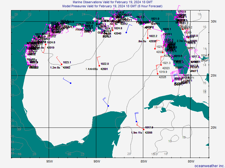
wxman57 wrote:Winds at the buoys are decreasing, and pressures rising slightly. Don't see much evidence of an LLC, just a MLC. Trof axis nearing the TX coast.
How close are we to an image of a 1960's TV sci-fi series medico pronouncing mortality?
0 likes
-
srainhoutx

- S2K Supporter

- Posts: 6919
- Age: 66
- Joined: Sun Jan 14, 2007 11:34 am
- Location: Haywood County, NC
- Contact:
Re: Invest 90L up again,West GOM-Discussion & Images
Ed Mahmoud wrote:wxman57 wrote:Winds at the buoys are decreasing, and pressures rising slightly. Don't see much evidence of an LLC, just a MLC. Trof axis nearing the TX coast.
How close are we to an image of a 1960's TV sci-fi series medico pronouncing mortality?
0 likes
-
Extremeweatherguy

- Category 5

- Posts: 11095
- Joined: Mon Oct 10, 2005 8:13 pm
- Location: Houston, TX

-
srainhoutx
- S2K Supporter
- Posts: 6919
- Age: 66
- Joined: Sun Jan 14, 2007 11:34 am
- Location: Haywood County, NC
- Contact:
Re: Invest 90L up again,West GOM-Discussion & Images
Hmmm. Warranted a Special Feature and now Conducive for development per TWD...
http://www.nhc.noaa.gov/text/refresh/MI ... 1746.shtml?
http://www.nhc.noaa.gov/text/refresh/MI ... 1746.shtml?
0 likes
-
destruction92
- Category 1

- Posts: 312
- Joined: Sun Jul 22, 2007 10:43 pm
Re: Invest 90L up again,West GOM-Discussion & Images
ROCK wrote:yeah, Destruction92----it will never make it into the GOM either...
I never suggested that it would not "make it into the GOM either". Seriously, give it a rest. We all have our own opinions, but it does not mean we have to go out of our way to disparage one another.
I don't see much potential with this system because it looks unhealthy right now, has no convection around its center of circulation, has no low-level circulation, and is way too close to the coast. On top of that it is near a cold front that is still active...this front has not stalled out and is depicted with blue lining on the surface analysis map...see for yourself...

0 likes
-
terrapintransit

- Category 1
- Posts: 275
- Age: 49
- Joined: Tue Sep 04, 2007 8:08 pm
- Location: Williamsport, Pa
-
HouTXmetro

- Category 5
- Posts: 3949
- Joined: Sun Jun 13, 2004 6:00 pm
- Location: District of Columbia, USA

-
HouTXmetro
- Category 5
- Posts: 3949
- Joined: Sun Jun 13, 2004 6:00 pm
- Location: District of Columbia, USA
Re: Invest 90L up again,West GOM-Discussion & Images
Do you all think the convection will start ramping back up in the next 2-4 hours?
Last edited by HouTXmetro on Tue Sep 11, 2007 7:50 pm, edited 2 times in total.
0 likes
-
HURAKAN

- Professional-Met

- Posts: 46086
- Age: 37
- Joined: Thu May 20, 2004 4:34 pm
- Location: Key West, FL
- Contact:
TD HUMBERTO (Inland): Global & BAM MODELS
484
WHXX01 KWBC 120043
CHGHUR
TROPICAL CYCLONE GUIDANCE MESSAGE
NWS TPC/NATIONAL HURRICANE CENTER MIAMI FL
0043 UTC WED SEP 12 2007
DISCLAIMER...NUMERICAL MODELS ARE SUBJECT TO LARGE ERRORS.
PLEASE REFER TO NHC OFFICIAL FORECASTS FOR TROPICAL CYCLONE
AND SUBTROPICAL CYCLONE INFORMATION.
ATLANTIC OBJECTIVE AIDS FOR
DISTURBANCE INVEST (AL902007) 20070912 0000 UTC
...00 HRS... ...12 HRS... ...24 HRS. .. ...36 HRS...
070912 0000 070912 1200 070913 0000 070913 1200
LAT LON LAT LON LAT LON LAT LON
BAMS 26.2N 94.9W 26.8N 96.0W 27.5N 97.1W 28.3N 98.1W
BAMD 26.2N 94.9W 26.6N 95.8W 27.3N 96.7W 28.5N 97.1W
BAMM 26.2N 94.9W 26.7N 96.0W 27.4N 96.9W 28.3N 97.6W
LBAR 26.2N 94.9W 26.4N 95.6W 27.1N 96.5W 28.1N 97.2W
SHIP 20KTS 25KTS 31KTS 37KTS
DSHP 20KTS 25KTS 31KTS 28KTS
...48 HRS... ...72 HRS... ...96 HRS. .. ..120 HRS...
070914 0000 070915 0000 070916 0000 070917 0000
LAT LON LAT LON LAT LON LAT LON
BAMS 29.0N 98.6W 29.3N 101.1W 30.4N 105.5W 32.8N 107.8W
BAMD 29.9N 97.2W 30.8N 97.7W 31.3N 100.5W 34.4N 102.6W
BAMM 29.2N 98.0W 29.2N 99.9W 29.9N 104.3W 32.5N 107.2W
LBAR 29.5N 97.4W 32.4N 95.7W 33.7N 91.9W 35.4N 86.9W
SHIP 45KTS 56KTS 63KTS 65KTS
DSHP 27KTS 27KTS 27KTS 27KTS
...INITIAL CONDITIONS...
LATCUR = 26.2N LONCUR = 94.9W DIRCUR = 305DEG SPDCUR = 2KT
LATM12 = 26.0N LONM12 = 94.6W DIRM12 = 340DEG SPDM12 = 3KT
LATM24 = 25.0N LONM24 = 94.3W
WNDCUR = 20KT RMAXWD = 60NM WNDM12 = 20KT
CENPRS = 1009MB OUTPRS = 1012MB OUTRAD = 180NM SDEPTH = S
RD34NE = 0NM RD34SE = 0NM RD34SW = 0NM RD34NW = 0NM
$$
NNNN
0 likes
-
Ed Mahmoud
Re: Invest 90L up again,West GOM-Discussion & Images
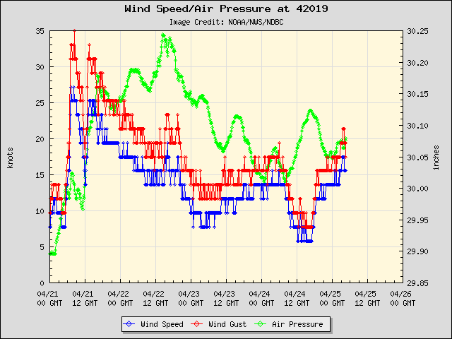
Pressure still falling slightly at databuoy South of Freeport...
0 likes
-
HoustonTexas
- Tropical Low

- Posts: 12
- Joined: Thu May 04, 2006 6:01 pm
-
jasons2k

- Storm2k Executive

- Posts: 8088
- Age: 50
- Joined: Wed Jul 06, 2005 12:32 pm
- Location: The Woodlands, TX
What a headache. One one hand, the convection is completely falling apart & it looks pitiful, on the other, I see a ship report with a pressure of 1010.7 south of Galveston and a waterspout was reported an hour ago over Copano Bay...we usually don't see waterspouts in the evening time unless something is going on. I don't think we'll really know what plans 90L has until tomorrow...
0 likes

Re: Invest 90L up again,West GOM-Discussion & Images
For what its worth, weak western gulf systems seem to often follow the opposite of the DMIN DMAX rules, flaring up in the afternoon and dying down in the evening. I wouldnt write it off as a potential tropical cyclone yet, especially if it refires tonight or tomorrow morning.
0 likes
Who is online
Users browsing this forum: No registered users and 7 guests