Wow this is a big storm...the convection is
over a large area
Typhoon Man-yi (04W)
Moderator: S2k Moderators
-
Tampa Bay Hurricane

- Category 5

- Posts: 5594
- Age: 36
- Joined: Fri Jul 22, 2005 7:54 pm
- Location: St. Petersburg, FL
-
HurricaneRobert
- Category 3

- Posts: 812
- Joined: Fri May 18, 2007 9:31 pm


-
whereverwx
- Category 5
- Posts: 1109
- Joined: Mon May 31, 2004 10:15 pm
Re:
wxmann_91 wrote:I don't know if this will get as strong as JT's advertising. It's just too big and there's competing convection everywhere. On the flip side though, the outflow pattern's nearly perfect, thermodynamics look good, and there's good upper diffluence and low level convergence. We'll see what happens.
That's exactly what I was thinking, too, because it is very large, and large systems typically require more time to get organized. Lastly . . . "We'll see what happens."


Also, I suppose this map would be useful for those who want to compare the size of this cyclone, and others, to landmasses using the squares.

If you are curious, you can find it here.
0 likes
-
wxmann_91

- Category 5
- Posts: 8013
- Age: 33
- Joined: Fri Jul 15, 2005 2:49 pm
- Location: Southern California
- Contact:
Since my post, Man-yi has consolidated somewhat with deep convection firing over the center. Not sure if it means anything though or not, it will only mean something if it survives the diurnal minimum.
Does anybody know why NRL hasn't updated with this storm? It still has 94W INVEST and the original position 48 hr ago. Also, JTWC's website is down I think.
Does anybody know why NRL hasn't updated with this storm? It still has 94W INVEST and the original position 48 hr ago. Also, JTWC's website is down I think.
0 likes
-
WindRunner

- Category 5
- Posts: 5806
- Age: 33
- Joined: Fri Jul 29, 2005 8:07 pm
- Location: Warrenton, VA, but Albany, NY for school
- Contact:
FWIW, I looked at the Euro and CMC this morning when I was up in the office and the 00z run of the Canadian took it down to 969hPa and the Euro took it to 947hPa. Pretty impressive to start with, and then take into account the grid-scale sampling . . . we could have a monster, a bona-fide SS Cat 5 if that verifies . . .
And the GFS still didn't take it below 1000hPa
And the GFS still didn't take it below 1000hPa
0 likes
-
windstorm99

- S2K Supporter

- Posts: 1578
- Age: 46
- Joined: Sat May 26, 2007 8:10 am
- Location: Miami, Florida
- Contact:
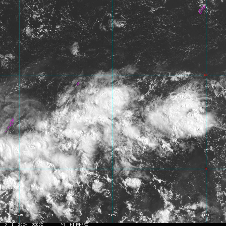


Think one reason why it looks so large is that it's enveloped in the cyclonic envelope of the MJO. Once it consolidates, given the very moist envelope and outstanding upper level environment, this has a high probability of strengthening very quickly. But as others have pointed out, usually these very large storms take awhile to consolidate.
0 likes
-
alan1961

- Category 2

- Posts: 767
- Joined: Mon Mar 20, 2006 11:58 am
- Location: Derby, Derbyshire, England
- Contact:
Re: Tropical Storm MAN-YI (04w) in WPAC
this is looking an absolute BRUTE of a system, god knows what the pressure will be when it really starts to wind up, its really been on the cards for one of these, sst's must be boiling over in the western pacific and it needs some of that heat releasing, how the people in the areas that are at risk from these monsters can sleep at night i'll never know, and we think the Atlantic is dangerous! 
0 likes
-
Matt-hurricanewatcher
- Category 5
- Posts: 11649
- Age: 38
- Joined: Fri Nov 26, 2004 11:09 pm
- Location: Portland,OR
- Contact:
Re: Tropical Storm MAN-YI (04w) in WPAC
If this was in the Atlantic at 12 north/40 west it would not be a named system yet. The nhc would likely be saying that a depression can be expected tonight or Monday morning. Really Iris 2005(cape verde depression/storm) I think that was the system, that looked like this in that area.


Personally it looks like a 45-50 mph system,. Very nice system, and should become a very powerful cyclone.
Personally it looks like a 45-50 mph system,. Very nice system, and should become a very powerful cyclone.
0 likes

RSMC TROPICAL CYCLONE ADVISORY
NAME TS 0704 MAN-YI (0704)
ANALYSIS
PSTN 090000UTC 09.1N 143.0E FAIR
MOVE WNW 15KT
PRES 994HPA
MXWD 040KT
GUST 060KT
30KT 150NM
FORECAST
24HF 100000UTC 10.8N 138.6E 80NM 70%
MOVE WNW 12KT
PRES 980HPA
MXWD 055KT
GUST 080KT
48HF 110000UTC 14.6N 134.4E 150NM 70%
MOVE NW 14KT
PRES 960HPA
MXWD 075KT
GUST 105KT
72HF 120000UTC 18.9N 129.9E 270NM 70%
MOVE NW 15KT
PRES 950HPA
MXWD 080KT
GUST 115KT
Up to 40 kts now.
And NRL hasn't updated in days with the names, but imagery is updated.
0 likes
-
Matt-hurricanewatcher
- Category 5
- Posts: 11649
- Age: 38
- Joined: Fri Nov 26, 2004 11:09 pm
- Location: Portland,OR
- Contact:
Re: Tropical Storm MAN-YI (04w) in WPAC
Thisi system look very good, with outflow jets out from the south and north. I expect that a Cdo will form. In then it will take a shot at one of the more powerful systems in strength last year.
Last edited by Matt-hurricanewatcher on Sun Jul 08, 2007 8:52 pm, edited 1 time in total.
0 likes
-
alan1961
- Category 2
- Posts: 767
- Joined: Mon Mar 20, 2006 11:58 am
- Location: Derby, Derbyshire, England
- Contact:
Re: Tropical Storm MAN-YI (04w) in WPAC
Matt-hurricanewatcher wrote:If this was in the Atlantic at 12 north/40 west it would not be a named system yet. The nhc would likely be saying that a depression can be expected tonight or Monday morning. Really Iris 2005(cape verde depression/storm) I think that was the system, that looked like this in that area.
Personally it looks like a 45-50 mph system,. Very nice system, and should become a very powerful cyclone.
yes Matt, some of the very far feeder bands are almost over papua new guinea it is that large, it is quite low down as you say but is forecast to miss the phillipines only to clobber somewhere else, maybe Taiwan, nothing certain yet though
0 likes
-
cycloneye

- Admin

- Posts: 139346
- Age: 67
- Joined: Thu Oct 10, 2002 10:54 am
- Location: San Juan, Puerto Rico
Re:
Chacor wrote:RSMC TROPICAL CYCLONE ADVISORY
NAME TS 0704 MAN-YI (0704)
ANALYSIS
PSTN 090000UTC 09.1N 143.0E FAIR
MOVE WNW 15KT
PRES 994HPA
MXWD 040KT
GUST 060KT
30KT 150NM
FORECAST
24HF 100000UTC 10.8N 138.6E 80NM 70%
MOVE WNW 12KT
PRES 980HPA
MXWD 055KT
GUST 080KT
48HF 110000UTC 14.6N 134.4E 150NM 70%
MOVE NW 14KT
PRES 960HPA
MXWD 075KT
GUST 105KT
72HF 120000UTC 18.9N 129.9E 270NM 70%
MOVE NW 15KT
PRES 950HPA
MXWD 080KT
GUST 115KT
Up to 40 kts now.
And NRL hasn't updated in days with the names, but imagery is updated.
NRL'S main site has been with problems in the past few days.However,the backup site is fine updating everything.
http://tcweb.fnmoc.navy.mil/tc-bin/tc_home.cgi
0 likes
-
WindRunner
- Category 5
- Posts: 5806
- Age: 33
- Joined: Fri Jul 29, 2005 8:07 pm
- Location: Warrenton, VA, but Albany, NY for school
- Contact:
Probably won't clobber much of anything, as the models either show it hitting Taiwan/Central China as a borderline typhoon (1-min), or they bomb it out and take it north towards the southern tip of Japan, at which point it is swept away by a strong shortwave before the outer bands get to seriously effect the Home Islands.
0 likes
-
WindRunner
- Category 5
- Posts: 5806
- Age: 33
- Joined: Fri Jul 29, 2005 8:07 pm
- Location: Warrenton, VA, but Albany, NY for school
- Contact:
Re: Re:
cycloneye wrote:Chacor wrote:And NRL hasn't updated in days with the names, but imagery is updated.
NRL'S main site has been with problems in the past few days.However,the backup site is fine updating everything.
http://tcweb.fnmoc.navy.mil/tc-bin/tc_home.cgi
Main site (http://www.nrlmry.navy.mil/tc_pages/tc_home.html) is still not updating positions/strengths/locations, though.
Though thank you for reminding me of the backup site, had almost forgotten. That will make things far easier in the coming days . . .
0 likes
Up to 45 kts from Guam (probably JTWC as well at next adv):
836
WTPQ31 PGUM 090059
TCPPQ1
BULLETIN
TROPICAL STORM MAN-YI (04W) INTERMEDIATE ADVISORY NUMBER 6A
NATIONAL WEATHER SERVICE TIYAN GU
1100 AM GUAM LST MON JUL 9 2007
...TROPICAL STORM MAN-YI BEGINNING TO INTENSIFY...
AS OF 11 AM GUAM LST...THE TROPICAL STORM WARNING FOR FARAULEP IS
CANCELLED. TROPICAL STORM CONDITIONS HAVE ENDED.
A TROPICAL STORM WARNING REMAINS IN EFFECT FOR FAIS AND ULITHI IN
YAP STATE. TROPICAL STORM FORCE WINDS OF 39 MPH OR MORE ARE EXPECTED
LATE THIS AFTERNOON AND TONIGHT.
AT 10 AM GUAM LST...0000Z...THE CENTER OF TROPICAL STORM MAN-YI WAS
LOCATED NEAR LATITUDE 10.2 DEGREES NORTH AND LONGITUDE 142.7 DEGREES
EAST. THIS IS ABOUT 170 MILES NORTHWEST OF FARAULEP
150 MILES EAST OF FAIS
210 MILES EAST OF ULITHI
315 MILES EAST OF YAP
380 MILES EAST-NORTHEAST OF NGULU
265 MILES SOUTH-SOUTHWEST OF GUAM.
TROPICAL STORM MAN-YI IS MOVING NORTHWEST AT 18 MPH. THIS GENERAL
MOTION IS EXPECTED TO CONTINUE THROUGH TONIGHT WITH A DECREASE IN
FORWARD SPEED.
MAXIMUM SUSTAINED WINDS HAVE INCREASED TO 50 MPH. TROPICAL STORM
MAN-YI IS EXPECTED TO INTENSIFY FURTHER THIS AFTERNOON AND TONIGHT.
REPEATING THE 10 AM GUAM LST POSITION...LATITUDE 10.2 DEGREES NORTH
AND LONGITUDE 142.7 DEGREES EAST...MOVING NORTHWEST AT 18 MPH WITH
MAXIMUM SUSTAINED WINDS OF 50 MPH.
THE NEXT SCHEDULED ADVISORY WILL BE ISSUED BY THE NATIONAL WEATHER
SERVICE AT 2 PM GUAM LST...FOLLOWED BY AN INTERMEDIATE ADVISORY AT
5 PM.
$$
MIDDLEBROOKE
0 likes
-
wxmann_91
- Category 5
- Posts: 8013
- Age: 33
- Joined: Fri Jul 15, 2005 2:49 pm
- Location: Southern California
- Contact:
Re:
WindRunner wrote:cycloneye wrote:Chacor wrote:And NRL hasn't updated in days with the names, but imagery is updated.
NRL'S main site has been with problems in the past few days.However,the backup site is fine updating everything.
http://tcweb.fnmoc.navy.mil/tc-bin/tc_home.cgi
Main site (http://www.nrlmry.navy.mil/tc_pages/tc_home.html) is still not updating positions/strengths/locations, though.
Though thank you for reminding me of the backup site, had almost forgotten. That will make things far easier in the coming days . . .
I hd forgotten about the backup site too... thanks for the reminder Luis.
WindRunner wrote:FWIW, I looked at the Euro and CMC this morning when I was up in the office and the 00z run of the Canadian took it down to 969hPa and the Euro took it to 947hPa. Pretty impressive to start with, and then take into account the grid-scale sampling . . . we could have a monster, a bona-fide SS Cat 5 if that verifies . . .
And the GFS still didn't take it below 1000hPa
Wow. The CMC is usually bonkers but didn't know the EURO did it too. FWIW, the CMC did initialize about 10 mb too deep.
BTW, for kicks, the 070708/1200 run of the CMC shows an eye, per the 700mb RH fields progged at 60hr.
0 likes
-
wxmann_91
- Category 5
- Posts: 8013
- Age: 33
- Joined: Fri Jul 15, 2005 2:49 pm
- Location: Southern California
- Contact:
Examining the synoptic pattern progged, I suspect that any RI that could occur will wait until ~48 hr as a polar outflow channel begins to open up. A monsoonal trough is helping with equatorial outflow, and easterly outflow is enhanced by an ULL ventilating to the northeast. Just some outflow restriction in the NW Quad. Per Euro and CMC, a longwave trough near Japan will induce a weakness in the 500mb ridge, and that will alleviate the current northerly shear issues.
0 likes
RSMC TROPICAL CYCLONE ADVISORY
NAME TS 0704 MAN-YI (0704)
ANALYSIS
PSTN 090300UTC 10.5N 142.1E FAIR
MOVE WNW 16KT
PRES 994HPA
MXWD 040KT
GUST 060KT
30KT 150NM
FORECAST
24HF 100300UTC 12.1N 138.1E 80NM 70%
MOVE WNW 11KT
PRES 980HPA
MXWD 055KT
GUST 080KT
45HF 110000UTC 14.6N 134.4E 150NM 70%
MOVE NW 14KT
PRES 960HPA
MXWD 075KT
GUST 105KT
69HF 120000UTC 18.9N 129.9E 270NM 70%
MOVE NW 15KT
PRES 950HPA
MXWD 080KT
GUST 115KT
0 likes
Who is online
Users browsing this forum: No registered users and 12 guests