

TD INGRID: Discussions & Images - Last Advisory
Moderator: S2k Moderators
Re: Invest 91L East Atlantic-Discussions & Images
Raggy, but it is pulling that surface flow to its NW down into it, like Fleix.
I guess we can extrapolate another Caribbean-bound cyclone.
I guess we can extrapolate another Caribbean-bound cyclone.
0 likes
-
HURAKAN

- Professional-Met

- Posts: 46086
- Age: 37
- Joined: Thu May 20, 2004 4:34 pm
- Location: Key West, FL
- Contact:
Re: Invest 91L East Atlantic-Discussions & Images
Sanibel wrote:Raggy, but it is pulling that surface flow to its NW down into it, like Fleix.
I guess we can extrapolate another Caribbean-bound cyclone.
This time the high pressure is not that strong. We may see a fish out of this if we get lucky!!
0 likes

Re: Invest 91L East Atlantic-Discussions & Images
May be for the USA, but not for the lesser Antilles yet.
0 likes
-
Gustywind

- Category 5

- Posts: 12334
- Joined: Mon Sep 03, 2007 7:29 am
- Location: Baie-Mahault, GUADELOUPE
Our first concern should be for the islands, it appears. This system may become a real threat to them.
Absolutely Zardoz, the first models don't put it too far away of the islands, only one model is ok for a fish..... , too early to speculate but the first trend seems tu put it once again on the ISLANDS. Maybe this time heading little to the north, Leewards/ Northern Leewards islands, Puerto Rico hope no...
  Plenty of time to watch this system!
Absolutely Zardoz, the first models don't put it too far away of the islands, only one model is ok for a fish.....
, too early to speculate but the first trend seems tu put it once again on the ISLANDS. Maybe this time heading little to the north, Leewards/ Northern Leewards islands, Puerto Rico hope no... Plenty of time to watch this system!
0 likes
-
chadtm80
- Category 5
- Posts: 20381
- Age: 43
- Joined: Tue Oct 08, 2002 8:35 am
- Location: East Central Florida
- Contact:
Re: Invest 91L East Atlantic-Discussions & Images
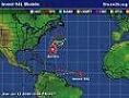
Here is the s2k 91L image.. Both 91L and 90L info will be up on storm2k shortly..(Gabrielle already there)

0 likes

-
Gustywind
- Category 5
- Posts: 12334
- Joined: Mon Sep 03, 2007 7:29 am
- Location: Baie-Mahault, GUADELOUPE
Tropical wave off the coast of Africa (91L)
A strong tropical wave near 10N 34W, a few hundred miles southwest of the Cape Verdes Islands off the coast of Africa, is kicking up some disorganized heavy thunderstorm activity. This disturbance was designated "91L" by NHC this morning. Last night's QuikSCAT pass showed a broad, ill-defined circulation associated with the disturbance. The disturbance is under about 10 knots of wind shear. Shear is forecast to remain below 10 knots over the disturbance over the next few days, and this system has the potential to develop as it heads west at 15 mph. Several of the computer models do develop this system, and predict that it may begin to acquire a more northwesterly track in response to a big non-tropical storm over the mid-Atlantic between Europe and the U.S. This disturbance has an environment similar to the one that spawned Hurricane Dean. The GFS-based SHIPS intensity model is forecasting that this will be a Category 1 hurricane 4-5 days from now, and I am expecting at least a tropical storm will form by then.
I'll have an update Monday morning.
Jeff Masters
0 likes


Re:
Gustywind wrote:Tropical wave off the coast of Africa (91L)
A strong tropical wave near 10N 34W, a few hundred miles southwest of the Cape Verdes Islands off the coast of Africa, is kicking up some disorganized heavy thunderstorm activity. This disturbance was designated "91L" by NHC this morning. Last night's QuikSCAT pass showed a broad, ill-defined circulation associated with the disturbance. The disturbance is under about 10 knots of wind shear. Shear is forecast to remain below 10 knots over the disturbance over the next few days, and this system has the potential to develop as it heads west at 15 mph. Several of the computer models do develop this system, and predict that it may begin to acquire a more northwesterly track in response to a big non-tropical storm over the mid-Atlantic between Europe and the U.S. This disturbance has an environment similar to the one that spawned Hurricane Dean. The GFS-based SHIPS intensity model is forecasting that this will be a Category 1 hurricane 4-5 days from now, and I am expecting at least a tropical storm will form by then.
I'll have an update Monday morning.
Jeff Masters
Cat 1 4-5 days from now
0 likes
-
Derek Ortt
-
DIDDLESBABE

- Tropical Low

- Posts: 33
- Joined: Tue Aug 31, 2004 6:07 am
- Location: Ft. Myers, FL.

Re: Invest 91L East Atlantic-Discussions=11:30 AM TWO Shortly
I have a question...
The 00Z GFS (09/09) moves the large North-Atlantic low Northwest, and replaces it with a High Pressure system at around 60-84 hours.
http://www.nco.ncep.noaa.gov/pmb/nwprod ... l_lu.shtml
Wouldn't this development remove the pull Northwards?
The 00Z GFS (09/09) moves the large North-Atlantic low Northwest, and replaces it with a High Pressure system at around 60-84 hours.
http://www.nco.ncep.noaa.gov/pmb/nwprod ... l_lu.shtml
Wouldn't this development remove the pull Northwards?
0 likes
-
cycloneye

- Admin

- Posts: 139593
- Age: 67
- Joined: Thu Oct 10, 2002 10:54 am
- Location: San Juan, Puerto Rico
Re: Invest 91L East Atlantic-Discussions=11:30 AM TWO Shortly
ABNT20 KNHC 091530
TWOAT
TROPICAL WEATHER OUTLOOK
NWS TPC/NATIONAL HURRICANE CENTER MIAMI FL1
1130 AM EDT SUN SEP 9 2007
FOR THE NORTH ATLANTIC...CARIBBEAN SEA AND THE GULF OF MEXICO...
THE NATIONAL HURRICANE CENTER IS ISSUING ADVISORIES ON TROPICAL
STORM GABRIELLE...CENTERED NEAR THE COAST OF NORTH CAROLINA BETWEEN
CAPE LOOKOUT AND OCRACOKE INLET.
A BROAD AREA OF LOW PRESSURE...ASSOCIATED WITH A TROPICAL WAVE...IS
LOCATED ABOUT 700 MILES WEST-SOUTHWEST OF THE CAPE VERDE ISLANDS
AND IS PRODUCING A LARGE AREA OF CLOUDINESS AND THUNDERSTORMS.
CONDITIONS APPEAR CONDUCIVE FOR GRADUAL DEVELOPMENT OF THIS SYSTEM
DURING THE NEXT COUPLE OF DAYS AS IT MOVES WESTWARD AT ABOUT 15
MPH.
$$
FORECASTER KNABB
WWWW
0 likes
-
Gustywind
- Category 5
- Posts: 12334
- Joined: Mon Sep 03, 2007 7:29 am
- Location: Baie-Mahault, GUADELOUPE
Gustywind wrote:
Tropical wave off the coast of Africa (91L)
A strong tropical wave near 10N 34W, a few hundred miles southwest of the Cape Verdes Islands off the coast of Africa, is kicking up some disorganized heavy thunderstorm activity. This disturbance was designated "91L" by NHC this morning. Last night's QuikSCAT pass showed a broad, ill-defined circulation associated with the disturbance. The disturbance is under about 10 knots of wind shear. Shear is forecast to remain below 10 knots over the disturbance over the next few days, and this system has the potential to develop as it heads west at 15 mph. Several of the computer models do develop this system, and predict that it may begin to acquire a more northwesterly track in response to a big non-tropical storm over the mid-Atlantic between Europe and the U.S. This disturbance has an environment similar to the one that spawned Hurricane Dean. The GFS-based SHIPS intensity model is forecasting that this will be a Category 1 hurricane 4-5 days from now, and I am expecting at least a tropical storm will form by then.
I'll have an update Monday morning.
Jeff Masters
cangrl04 wrote;
"Cat 1 4-5 days from now I hope US coastal residents are thinking of preparations. Steve Lyons said TD in 24-36 hours"
Heuu cangrl04, yeah , but us in the islands will be first concerned if this is confirmed for us before you in the US so in my humble thought with my whole humility there's plenty of time of to speculate on the perfect path of this, we will see what happens, but i like your suroptimism lool
Tropical wave off the coast of Africa (91L)
A strong tropical wave near 10N 34W, a few hundred miles southwest of the Cape Verdes Islands off the coast of Africa, is kicking up some disorganized heavy thunderstorm activity. This disturbance was designated "91L" by NHC this morning. Last night's QuikSCAT pass showed a broad, ill-defined circulation associated with the disturbance. The disturbance is under about 10 knots of wind shear. Shear is forecast to remain below 10 knots over the disturbance over the next few days, and this system has the potential to develop as it heads west at 15 mph. Several of the computer models do develop this system, and predict that it may begin to acquire a more northwesterly track in response to a big non-tropical storm over the mid-Atlantic between Europe and the U.S. This disturbance has an environment similar to the one that spawned Hurricane Dean. The GFS-based SHIPS intensity model is forecasting that this will be a Category 1 hurricane 4-5 days from now, and I am expecting at least a tropical storm will form by then.
I'll have an update Monday morning.
Jeff Masters
cangrl04 wrote;
"Cat 1 4-5 days from now I hope US coastal residents are thinking of preparations. Steve Lyons said TD in 24-36 hours"
Heuu cangrl04, yeah , but us in the islands will be first concerned if this is confirmed for us before you in the US
0 likes
-
Gustywind
- Category 5
- Posts: 12334
- Joined: Mon Sep 03, 2007 7:29 am
- Location: Baie-Mahault, GUADELOUPE
SHIPS assumes that this is already a TD; thus, its output should not be used
That said, this could become a hurricane and could be near the islands in 5 days time
Are you sure about that Derek Ortt?
Not good news for us in the islands maybe 
At what latitude do you tkink it will cross this time Derek ? tkanks gusty!

That said, this could become a hurricane and could be near the islands in 5 days time
Are you sure about that Derek Ortt?
Not good news for us in the islands maybe
At what latitude do you tkink it will cross this time Derek ? tkanks gusty!
0 likes
Re: Invest 91L East Atlantic-Discussions=11:30 AM TWO at page 2
15mph forward speed is slower than Dean. So that means the ridge isn't as strong and a possibly more WNW track could follow.
0 likes
Who is online
Users browsing this forum: No registered users and 3 guests