

Cyclone Monica - Cat. 5
Moderator: S2k Moderators


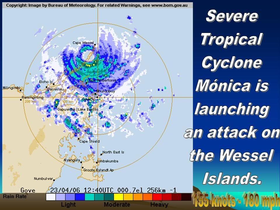


What a beast. I hope there is some automated station that survives and reports as most likely it is one of the strongest cyclones to hit land in quite some time. I don't know exact stats for the Australia area but to have a certain Category 5 at peak intensity hitting with a pressure anywhere from 875-900 mb.. quite historical. Anyone have a list of TCs to make landfall and their associated pressures/winds (in Australia)??? Cape Wessel looks like they missed the worst of it as they are on the wrong side of the eyewall and they never really got into the main part of it.
0 likes
-
no advance
- Category 1

- Posts: 413
- Joined: Wed Aug 24, 2005 1:50 pm
- Location: merritt is.
-
AussieMark

- Category 5

- Posts: 5858
- Joined: Tue Sep 02, 2003 6:36 pm
- Location: near Sydney, Australia
LOWEST PRESSURE
STRONGEST WINDS
The lowest pressure recorded in Western Australia was 905 hPa at North Rankin A gas platform during cyclone Orson on 22-23 April 1989. On the Western Australian mainland the lowest pressure measured was 921 hPa at Onslow in 1961. In January 1980, 932 hPa was recorded at Goldsworthy as cyclone Amy passed approximately 10 km to the west.
STRONGEST WINDS
The strongest wind gust recorded on the Australian mainland is 267 km/h. The gust was recorded during cyclone Vance at 11:50 am (WST) 22 March 1999 at Learmonth Meteorological Office, 35 km south of Exmouth.
A gust of 267 km/h was also recorded at Varanus Island during cyclone Olivia in 1996. Wind gusts of 259 km/h at Mardie and 246 km/h at Onslow were measured during cyclone Trixie in February 1975.
By definition a category 5 cyclone produces gusts of at least 280 km/h. This means these gusts have gone unrecorded when category 5 cyclones have crossed the coast. Also, measurements of such winds are inherently going to be suspect as instruments often are completely destroyed or damaged at these speeds. The Onslow anemometer was destroyed after measuring the gust of 246 km/h during Trixie in 1975 as was the Darwin anemometer during Tracy also in 1974.
Last edited by AussieMark on Sun Apr 23, 2006 8:12 am, edited 2 times in total.
0 likes

-
weatherwoman132

- Category 1
- Posts: 305
- Joined: Wed Mar 08, 2006 7:26 pm
-
AussieMark
- Category 5
- Posts: 5858
- Joined: Tue Sep 02, 2003 6:36 pm
- Location: near Sydney, Australia
-
HURAKAN

- Professional-Met

- Posts: 46086
- Age: 37
- Joined: Thu May 20, 2004 4:34 pm
- Location: Key West, FL
- Contact:
Australian Government Bureau of Meteorology
Northern Territory
Darwin Regional Forecasting Centre
TOP PRIORITY
MEDIA: Transmitters serving the Gove area are requested to use the cyclone
emergency warning signal with this message.
TROPICAL CYCLONE WARNING
TROPICAL CYCLONE ADVICE NUMBER 58
Issued by the BUREAU OF METEOROLOGY, DARWIN
at 11:00 pm CST Sunday 23 April 2006
A CYCLONE WARNING is current for coastal and island communities between CAPE
SHIELD and POINT STUART, including NHULUNBUY, JABIRU and COBOURG PENINSULA.
A CYCLONE WATCH extends southwest between POINT STUART and PORT KEATS, including
DARWIN and the TIWI ISLANDS.
At 10 pm CST SEVERE TROPICAL CYCLONE Monica CATEGORY 5 was located about 100
kilometres north of NHULUNBUY, and 145 kilometres east northeast of ELCHO
ISLAND, moving west at 12 kilometres per hour. The cyclone should remain close
to its current intensity as it moves further west, just north of the northern
Top End coast overnight. The cyclone is expected to weaken slightly as it passes
over the base of COBOURG PENINSULA before reaching the northwest DARWIN-DALY and
TIWI ISLAND area early on Tuesday.
The VERY DESTRUCTIVE core of SEVERE TROPICAL CYCLONE Monica with gusts to 350
kilometres per hour is currently passing over the Wessel Islands, and is
expected to impact other islands of northeast Arnhem Land, including the
northern parts of ELCHO ISLAND in the next few hours. The VERY DESTRUCTIVE core
is then expected to impact the north coast of western Arnhem Land between
MILINGIMBI and CROKER ISLAND during Monday.
DESTRUCTIVE WINDS with gusts to 160 kilometres per hour are currently being
experienced on other islands of northeast Arnhem Land, and are expected to
extend further west as far as CROKER ISLAND during Monday.
GALES with gusts to 100 kilometres per hour are currently being experienced on
the far northeast Arnhem Land coast, and are expected to extend westwards as far
as POINT STUART and COBOURG PENINSULA on Monday night.
GALES will continue to extend westward and may develop over the northwest
DARWIN-DALY and TIWI ISLAND area on Tuesday morning.
DANGEROUSLY HIGH TIDES could cause EXTENSIVE FLOODING at the coast between CAPE
SHIELD and ELCHO ISLAND tonight.
HEAVY RAIN is expected to cause significant stream rises and flooding of low
lying areas in northeastern Arnhem Land tonight, extending across the remainder
of the northern Top End on Monday.
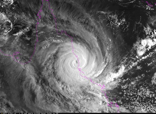
Details of SEVERE TROPICAL CYCLONE Monica at 10 pm CST:
. Centre located near...... 11.3 degrees South 136.7 degrees East
. Location accuracy........ within 30 kilometres
. Recent movement.......... towards the west at 12 km/h
. Wind gusts near centre... 350 kilometres per hour
. Intensity................ CATEGORY 5
. Central pressure......... 905 hectoPascals
REPEATING: A CYCLONE WARNING is current between CAPE SHIELD and POINT STUART,
including NHULUNBUY, JABIRU and COBOURG PENINSULA. A CYCLONE WATCH extends
southwest to PORT KEATS, including DARWIN and the TIWI ISLANDS.
The next advice will be issued at 2 am CST.
This advice is available on telephone NT-1300 659 211
DARWIN Tropical Cyclone Warning Centre
Northern Territory
Darwin Regional Forecasting Centre
TOP PRIORITY
MEDIA: Transmitters serving the Gove area are requested to use the cyclone
emergency warning signal with this message.
TROPICAL CYCLONE WARNING
TROPICAL CYCLONE ADVICE NUMBER 58
Issued by the BUREAU OF METEOROLOGY, DARWIN
at 11:00 pm CST Sunday 23 April 2006
A CYCLONE WARNING is current for coastal and island communities between CAPE
SHIELD and POINT STUART, including NHULUNBUY, JABIRU and COBOURG PENINSULA.
A CYCLONE WATCH extends southwest between POINT STUART and PORT KEATS, including
DARWIN and the TIWI ISLANDS.
At 10 pm CST SEVERE TROPICAL CYCLONE Monica CATEGORY 5 was located about 100
kilometres north of NHULUNBUY, and 145 kilometres east northeast of ELCHO
ISLAND, moving west at 12 kilometres per hour. The cyclone should remain close
to its current intensity as it moves further west, just north of the northern
Top End coast overnight. The cyclone is expected to weaken slightly as it passes
over the base of COBOURG PENINSULA before reaching the northwest DARWIN-DALY and
TIWI ISLAND area early on Tuesday.
The VERY DESTRUCTIVE core of SEVERE TROPICAL CYCLONE Monica with gusts to 350
kilometres per hour is currently passing over the Wessel Islands, and is
expected to impact other islands of northeast Arnhem Land, including the
northern parts of ELCHO ISLAND in the next few hours. The VERY DESTRUCTIVE core
is then expected to impact the north coast of western Arnhem Land between
MILINGIMBI and CROKER ISLAND during Monday.
DESTRUCTIVE WINDS with gusts to 160 kilometres per hour are currently being
experienced on other islands of northeast Arnhem Land, and are expected to
extend further west as far as CROKER ISLAND during Monday.
GALES with gusts to 100 kilometres per hour are currently being experienced on
the far northeast Arnhem Land coast, and are expected to extend westwards as far
as POINT STUART and COBOURG PENINSULA on Monday night.
GALES will continue to extend westward and may develop over the northwest
DARWIN-DALY and TIWI ISLAND area on Tuesday morning.
DANGEROUSLY HIGH TIDES could cause EXTENSIVE FLOODING at the coast between CAPE
SHIELD and ELCHO ISLAND tonight.
HEAVY RAIN is expected to cause significant stream rises and flooding of low
lying areas in northeastern Arnhem Land tonight, extending across the remainder
of the northern Top End on Monday.
Details of SEVERE TROPICAL CYCLONE Monica at 10 pm CST:
. Centre located near...... 11.3 degrees South 136.7 degrees East
. Location accuracy........ within 30 kilometres
. Recent movement.......... towards the west at 12 km/h
. Wind gusts near centre... 350 kilometres per hour
. Intensity................ CATEGORY 5
. Central pressure......... 905 hectoPascals
REPEATING: A CYCLONE WARNING is current between CAPE SHIELD and POINT STUART,
including NHULUNBUY, JABIRU and COBOURG PENINSULA. A CYCLONE WATCH extends
southwest to PORT KEATS, including DARWIN and the TIWI ISLANDS.
The next advice will be issued at 2 am CST.
This advice is available on telephone NT-1300 659 211
DARWIN Tropical Cyclone Warning Centre
0 likes

-
P.K.

- Professional-Met
- Posts: 5149
- Joined: Thu Sep 23, 2004 5:57 pm
- Location: Watford, England
- Contact:
HIGH SEAS WEATHER WARNING FOR METAREA 10/11
Issued by the AUSTRALIAN BUREAU OF METEOROLOGY, DARWIN
Issued at 1330 UTC 23 APRIL 2006
PLEASE BE AWARE
Wind gusts can be a further 40 percent stronger than the averages given here,
and maximum waves may be up to twice the height.
HURRICANE WARNING FOR NORTHERN AREA
SITUATION
At 1200 UTC Severe Tropical Cyclone Monica estimated within 15 nautical miles of
11.3 S 136.7 E moving west at 6 knots. Central pressure 905 hPa.
AREA AFFECTED
Within 60 nautical miles of the centre.
FORECAST
Sustained winds to 135 knots near centre.
Winds above 64 knots within 25 nautical miles of centre with very high to
phenomenal seas.
Winds above 48 knots within 30 nautical miles of centre with very rough to high
seas and moderate to heavy swell.
Winds above 34 knots within 60 nautical miles of centre with rough to very rough
seas and moderate swell.
0000 UTC 24 Apr: centre within 40 nautical miles of 11.3 S 134.9 E.
915 hPa. Winds to 125 knots near centre.
1200 UTC 24 Apr: centre within 75 nautical miles of 11.7 S 133.2 E.
915 hPa. Winds to 125 knots near centre.
REMARKS
Ships in the general area please transmit 3-hourly weather reports.
DARWIN Tropical Cyclone Warning Centre
0 likes
-
CHRISTY

Larry looked this strong only briefly:
http://cimss.ssec.wisc.edu/tropic/adt/17P-list.txt
There were a few pictures but really it didn't last so it could have been anything.. compare with this one:
http://cimss.ssec.wisc.edu/tropic/adt/23P-list.txt
Monica is much stronger for much longer. Around 12z it looked a lot like Rita to me...
http://cimss.ssec.wisc.edu/tropic/adt/17P-list.txt
There were a few pictures but really it didn't last so it could have been anything.. compare with this one:
http://cimss.ssec.wisc.edu/tropic/adt/23P-list.txt
Monica is much stronger for much longer. Around 12z it looked a lot like Rita to me...
0 likes
-
CHRISTY
Who is online
Users browsing this forum: No registered users and 1 guest