Hyperlink to JMA PDO Data
Hyperlink to ONI data since 1950


CFSv2 model:
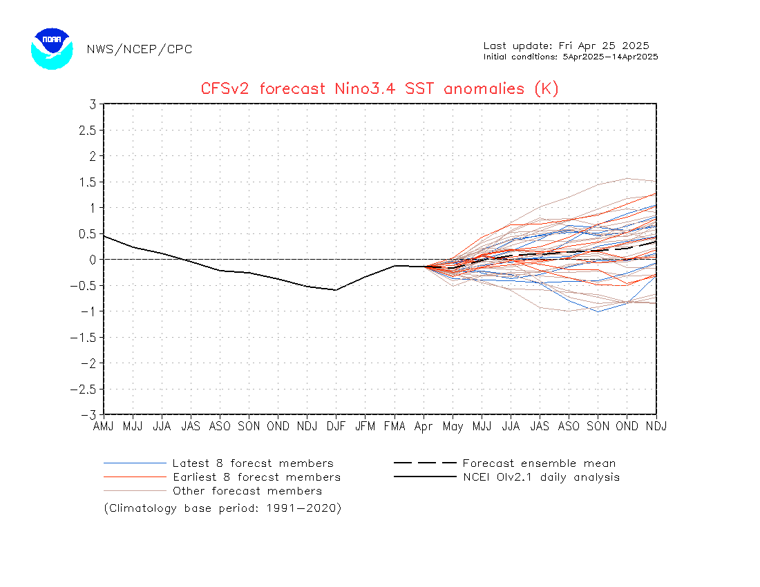


https://www.cpc.ncep.noaa.gov/products/ ... .sprd2.png
.
Moderator: S2k Moderators


SouthFloridawx wrote:Have we ever seen an moderate el-nino rapidly change into an moderate la-nina. I'm not saying this is a possibility however, I'm just wondering if this has ever happend?

SouthFloridawx wrote:Have we ever seen an moderate el-nino rapidly change into an moderate la-nina. I'm not saying this is a possibility however, I'm just wondering if this has ever happend?
AJC3 wrote:SouthFloridawx wrote:Have we ever seen an moderate el-nino rapidly change into an moderate la-nina. I'm not saying this is a possibility however, I'm just wondering if this has ever happend?
Rapid warm to cold phase transitions, both of which were of at least moderate strength, have occurred in the past. This chart of historical MEI (Multivariate ENSO Index) values might help you out...
http://www.cdc.noaa.gov/people/klaus.wo ... table.html
The rapid warm-to-cool transitions of significant strength that stood out to me were:
FEB to AUG 1973 (+1.544 to -1.684)
AUG 1987 to JUN 1988 (+1.911 to -1.182)
APR to NOV 1998 (+2.613 to -1.074)
SouthFloridawx wrote:
MEI values seem to be above normal the majority of the time from 2002 to now.
AJC3 wrote:SouthFloridawx wrote:
MEI values seem to be above normal the majority of the time from 2002 to now.
Not only that, there is a distinct transition from a higher strength and frequency of cold events to warm events around early 1976...
http://www.cdc.noaa.gov/people/klaus.wo ... I/mei.html
Lindaloo wrote:Could someone please translate what this means?


AJC3 wrote:SouthFloridawx wrote:
MEI values seem to be above normal the majority of the time from 2002 to now.
Not only that, there is a distinct transition from a higher strength and frequency of cold events to warm events around early 1976...
http://www.cdc.noaa.gov/people/klaus.wo ... I/mei.html

wxmann_91 wrote:AJC3 wrote:SouthFloridawx wrote:
MEI values seem to be above normal the majority of the time from 2002 to now.
Not only that, there is a distinct transition from a higher strength and frequency of cold events to warm events around early 1976...
http://www.cdc.noaa.gov/people/klaus.wo ... I/mei.html
That correlates well with the warm phase of the Pacific Decadal Oscillation (PDO).
http://jisao.washington.edu/pdo/


....nathan, for what its worth, i recall grey, landsea, et al discussion of the 1997 el nino...in which they suggested that the rapidity of transition from warm to cold was somewhat proportional to the strength of the warm event....richSouthFloridawx wrote:Have we ever seen an moderate el-nino rapidly change into an moderate la-nina. I'm not saying this is a possibility however, I'm just wondering if this has ever happend?