https://twitter.com/cyclonicwx/status/1753282724352196761
2024 ENSO: La Niña watch in effect: CPC May update on the 9th
Moderator: S2k Moderators
Forum rules

The posts in this forum are NOT official forecasts and should not be used as such. They are just the opinion of the poster and may or may not be backed by sound meteorological data. They are NOT endorsed by any professional institution or STORM2K. For official information, please refer to products from the National Hurricane Center and National Weather Service.
-
cycloneye

- Admin

- Posts: 139170
- Age: 67
- Joined: Thu Oct 10, 2002 10:54 am
- Location: San Juan, Puerto Rico
ENSO Updates: La Niña Watch in effect
1 likes
Visit the Caribbean-Central America Weather Thread where you can find at first post web cams,radars
and observations from Caribbean basin members Click Here
and observations from Caribbean basin members Click Here
-
DorkyMcDorkface

- Category 2

- Posts: 711
- Age: 26
- Joined: Mon Sep 30, 2019 1:32 pm
- Location: Mid-Atlantic
Re: ENSO Updates: CPC update Febuary 8 / January had 73% chance of Neutral by June
Interesting how much the PDO has been warming up over the past two weeks or so. Would be ironic to see a +PDO/-ENSO tandem right after -PDO/+ENSO but it obviously remains to be seen whether or not it sustains into the spring.

0 likes
Floyd 1999 | Isabel 2003 | Hanna 2008 | Irene 2011 | Sandy 2012 | Isaias 2020
-
Hurricane2022

- Category 4

- Posts: 930
- Joined: Tue Aug 23, 2022 11:38 pm
- Location: Araçatuba, Brazil
Re: ENSO Updates: CPC update Febuary 8 / January had 73% chance of Neutral by June
DorkyMcDorkface wrote:Interesting how much the PDO has been warming up over the past two weeks or so. Would be ironic to see a +PDO/-ENSO tandem right after -PDO/+ENSO but it obviously remains to be seen whether or not it sustains into the spring.
https://i.ibb.co/GMzt75n/crw-ssta-change-nepac.png
So perhaps a combo of +PDO and -ENSO could prevent the Atlantic from reaching its maximum potential for cyclonic activity? As a reverse of 2023, in which the boiling Atlantic waters may have prevented EPAC from achieving 200+ ACE points despite a moderate El Niño? (although with that we still saw 5 historic and memorable hurricanes in 2023... Dora, Hilary, Jova, Lidia and Otis)
0 likes
Sorry for the bad English sometimes...!
For reliable and detailed information for any meteorological phenomenon, please consult the National Hurricane Center, Joint Typhoon Warning Center , or your local Meteo Center.
--------
Una cvm Christo, pro Christo, et in Christo. Sit nomen Domini benedictvm.
For reliable and detailed information for any meteorological phenomenon, please consult the National Hurricane Center, Joint Typhoon Warning Center , or your local Meteo Center.
--------
Una cvm Christo, pro Christo, et in Christo. Sit nomen Domini benedictvm.
-
Kingarabian

- S2K Supporter

- Posts: 15439
- Joined: Sat Aug 08, 2009 3:06 am
- Location: Honolulu, Hawaii
Re: ENSO Updates: CPC update Febuary 8 / January had 73% chance of Neutral by June
DorkyMcDorkface wrote:Interesting how much the PDO has been warming up over the past two weeks or so. Would be ironic to see a +PDO/-ENSO tandem right after -PDO/+ENSO but it obviously remains to be seen whether or not it sustains into the spring.
https://i.ibb.co/GMzt75n/crw-ssta-change-nepac.png
Waters east of Japan are still above average which continue to affect the chances of an actual +PDO.
2 likes
RIP Kobe Bryant
-
DorkyMcDorkface
- Category 2
- Posts: 711
- Age: 26
- Joined: Mon Sep 30, 2019 1:32 pm
- Location: Mid-Atlantic
Re: ENSO Updates: CPC update Febuary 8 / January had 73% chance of Neutral by June
Kingarabian wrote:DorkyMcDorkface wrote:Interesting how much the PDO has been warming up over the past two weeks or so. Would be ironic to see a +PDO/-ENSO tandem right after -PDO/+ENSO but it obviously remains to be seen whether or not it sustains into the spring.
https://i.ibb.co/GMzt75n/crw-ssta-change-nepac.png
Waters east of Japan are still above average which continue to affect the chances of an actual +PDO.
Yeah index probably won't go fully positive until that fades (assuming it does). Seems like it relies heavily on that area from Japan to S of the Aleutians. A lot of the seasonal models have a warmer looking +PMM but maintain the warmth within the aforementioned belt.
0 likes
Floyd 1999 | Isabel 2003 | Hanna 2008 | Irene 2011 | Sandy 2012 | Isaias 2020
-
weeniepatrol

- Category 3

- Posts: 859
- Joined: Sat Aug 22, 2020 5:30 pm
- Location: WA State
Re: ENSO Updates: CPC update Febuary 8 / January had 73% chance of Neutral by June
As King said the Japan warmth is contributing a strong projection onto the negative phase of the pdo
1 likes
-
DorkyMcDorkface
- Category 2
- Posts: 711
- Age: 26
- Joined: Mon Sep 30, 2019 1:32 pm
- Location: Mid-Atlantic
Re: ENSO Updates: CPC update Febuary 8 / January had 73% chance of Neutral by June
weeniepatrol wrote:As King said the Japan warmth is contributing a strong projection onto the negative phase of the pdo
I think 2020 sort of had a similar look the second half of the year where the horseshoe was warm-ish but strongly +ve anoms persisted within that Japan to Aleutian belt, so it was -PDO in essence. Are there EOFs for PDO like there is for AMO? I would assume so but I am not as well versed with oceanic patterns in the Pacific (outside of ENSO) as I am with Atlantic ones (although the existence of AMO has been a point of contention as of late)
The PDO has generally been in the negative phase since the late 90s but of course we had that prominent positive period between 2014-2019, which produced some crazy EPAC seasons. I've still seen some debate as to whether or not it was a "blip" because it was a short period (not exactly "decadal").
Last edited by DorkyMcDorkface on Fri Feb 02, 2024 3:58 pm, edited 1 time in total.
0 likes
Floyd 1999 | Isabel 2003 | Hanna 2008 | Irene 2011 | Sandy 2012 | Isaias 2020
-
cycloneye
- Admin
- Posts: 139170
- Age: 67
- Joined: Thu Oct 10, 2002 10:54 am
- Location: San Juan, Puerto Rico
Re: ENSO Updates: CPC update Febuary 8 / January had 73% chance of Neutral by June
My question is, what does the warm waters off Japan mean for the general state of ENSO?
0 likes
Visit the Caribbean-Central America Weather Thread where you can find at first post web cams,radars
and observations from Caribbean basin members Click Here
and observations from Caribbean basin members Click Here
Re: ENSO Updates: CPC update Febuary 8 / January had 73% chance of Neutral by June
cycloneye wrote:My question is, what does the warm waters off Japan mean for the general state of ENSO?
That is the PDO. It typically cools in response to warm ENSO and warm in response to cool. The PDO is somewhat of a reddening/stochastic walk in response to extratropical and advective effects from ENSO forcing.
1 likes
All posts by Dean_175 are NOT official forecasts and should not be used as such. They are just the opinion of the poster and may or may not be backed by sound meteorological data. They are NOT endorsed by any professional institution or storm2k.org. For official information, please refer to the NHC and NWS products.
Re: ENSO Updates: CPC update Febuary 8 / January had 73% chance of Neutral by June
DorkyMcDorkface wrote:weeniepatrol wrote:As King said the Japan warmth is contributing a strong projection onto the negative phase of the pdo
I think 2020 sort of had a similar look the second half of the year where the horseshoe was warm-ish but strongly +ve anoms persisted within that Japan to Aleutian belt, so it was -PDO in essence. Are there EOFs for PDO like there is for AMO? I would assume so but I am not as well versed with oceanic patterns in the Pacific (outside of ENSO) as I am with Atlantic ones (although the existence of AMO has been a point of contention as of late)
The PDO has generally been in the negative phase since the late 90s but of course we had that prominent positive period between 2014-2019, which produced some crazy EPAC seasons. I've still seen some debate as to whether or not it was a "blip" because it was a short period (not exactly "decadal").
Yes. PDO is defined in terms of EOF SST patterns outside the tropics. It is basically a weighted measure of SSTAs where anomalies are taken into account accordingly based on the EOF weighting at each location and then added together.
Im not exactly sure if the brief robust warm period was some sort of blip or not. Ive wondered that myself. When you do spectral analysis on PDO, it shows that there are several different peaks and different factors at play. Reddening of ENSO influence is one big one but it's among several other drivers of extratropical conditions in the Pacific and PDO shows appreciable variance on many timescales. Basically a strong warm ENSO response causes PDO to increase but not necessarily "match" ENSO phase (red noise...random walk) or amplitude. A La Nina tends to decrease or "cool" the PDO while El Nino increases or warms it, with the change tendency being related to ENSO phase but with the actual PDO peaks not necessarily matching ENSO amplitude peaks (PDO doesnt necessarily peak when ENSO does, but sometimes does like in 1997 or 2015). ENSO is a 3-5 year cycle while PDO is much longer as a result.
There are other factors that can influence the extratropical temperatures in the Pacific, including just a seasonal change in depth of the mixing layer during winter causing previous anomalies to re-present themselves. PDO is multi-factorial and does not adjust immediately to ENSO.
It appears that this El Nino caused a reduction of negative PDO values but because PDO is driven more by a random walk of ENSO noise and other factors not driven by ENSO, there is still plenty of anomalously warm water extending over 1000km from Japan while at the same time water anomalously warms off the west coast of north America in response to El Nino. The two involve different processes and both are competing when it comes to PDO. The wayers of Japan were so warm going into this that it is keeping PDO positive although the warming off north america reduces the PDO value (due to EOF analysis!)
Last edited by Dean_175 on Fri Feb 02, 2024 8:01 pm, edited 3 times in total.
4 likes
All posts by Dean_175 are NOT official forecasts and should not be used as such. They are just the opinion of the poster and may or may not be backed by sound meteorological data. They are NOT endorsed by any professional institution or storm2k.org. For official information, please refer to the NHC and NWS products.
Re: ENSO Updates: CPC update Febuary 8 / January had 73% chance of Neutral by June
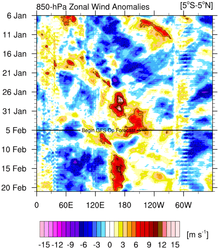
cycloneye wrote:https://twitter.com/cyclonicwx/status/1753282724352196761
This is one of those invaluable posts that can't be "liked" enough on a social media platform. This animation speaks 10,000 words. One of the mechanisms for ENSO phase locking (to the seasonal cycle) is the migration of the south Pacific convergence zone to a much more southerly latitude and the resultant decrease in westerly wind anomalies along the equator as you get deeper into the NH winter. Convective anomalies move south with real SST and the resultant westerly wind anomalies move south of the nino regions that are at the equator. In addition, it is also one of the big reasons Hawaii dries out during or after the peak of El Nino rather than prior.
6 likes
All posts by Dean_175 are NOT official forecasts and should not be used as such. They are just the opinion of the poster and may or may not be backed by sound meteorological data. They are NOT endorsed by any professional institution or storm2k.org. For official information, please refer to the NHC and NWS products.

-
cycloneye
- Admin
- Posts: 139170
- Age: 67
- Joined: Thu Oct 10, 2002 10:54 am
- Location: San Juan, Puerto Rico
Re: ENSO Updates: ONI for NDJ at +2.0C / CPC update February 8th
Landy wrote:ONI for NDJ is +2.0C.
Strong El Niño.

https://origin.cpc.ncep.noaa.gov/produc ... ONI_v5.php
1 likes
Visit the Caribbean-Central America Weather Thread where you can find at first post web cams,radars
and observations from Caribbean basin members Click Here
and observations from Caribbean basin members Click Here
-
cycloneye
- Admin
- Posts: 139170
- Age: 67
- Joined: Thu Oct 10, 2002 10:54 am
- Location: San Juan, Puerto Rico
Re: ENSO Updates: ONI for NDJ at +2.0C / CPC update February 8th
The Weekly CPC update has Niño 3.4 up to +1.8C.
https://www.cpc.ncep.noaa.gov/products/ ... ts-web.pdf
https://www.cpc.ncep.noaa.gov/products/ ... ts-web.pdf
0 likes
Visit the Caribbean-Central America Weather Thread where you can find at first post web cams,radars
and observations from Caribbean basin members Click Here
and observations from Caribbean basin members Click Here
-
cycloneye
- Admin
- Posts: 139170
- Age: 67
- Joined: Thu Oct 10, 2002 10:54 am
- Location: San Juan, Puerto Rico
Re: ENSO Updates: ONI for NDJ at +2.0C / CPC update February 8th
0 likes
Visit the Caribbean-Central America Weather Thread where you can find at first post web cams,radars
and observations from Caribbean basin members Click Here
and observations from Caribbean basin members Click Here
-
DorkyMcDorkface
- Category 2
- Posts: 711
- Age: 26
- Joined: Mon Sep 30, 2019 1:32 pm
- Location: Mid-Atlantic
Re: ENSO Updates: ONI for NDJ at +2.0C / CPC update February 8th
0 likes
Floyd 1999 | Isabel 2003 | Hanna 2008 | Irene 2011 | Sandy 2012 | Isaias 2020
-
Kingarabian
- S2K Supporter
- Posts: 15439
- Joined: Sat Aug 08, 2009 3:06 am
- Location: Honolulu, Hawaii
Re: ENSO Updates: ONI for NDJ at +2.0C / CPC update February 8th
Models have the MJO loitering in phases 7/8 and as such, another WWB is on the horizon.
0 likes
RIP Kobe Bryant
-
cycloneye
- Admin
- Posts: 139170
- Age: 67
- Joined: Thu Oct 10, 2002 10:54 am
- Location: San Juan, Puerto Rico
Re: ENSO Updates: CPC update February 8th
0 likes
Visit the Caribbean-Central America Weather Thread where you can find at first post web cams,radars
and observations from Caribbean basin members Click Here
and observations from Caribbean basin members Click Here
-
JetFuel_SE

- Category 1

- Posts: 268
- Age: 24
- Joined: Thu Apr 30, 2020 3:57 pm
-
DorkyMcDorkface
- Category 2
- Posts: 711
- Age: 26
- Joined: Mon Sep 30, 2019 1:32 pm
- Location: Mid-Atlantic
Re: ENSO Updates: CPC update February 8th
You can definitely see the cold pool beginning to undercut the warmth at the subsurface. Really starting to thin out to the east, which is likely why the cooler sliver of anoms in the 1+2 region is starting to appear. I initially thought the ongoing WWBs would slow progress but after seeing the tweet I posted yesterday I'm not so sure anymore.

3 likes
Floyd 1999 | Isabel 2003 | Hanna 2008 | Irene 2011 | Sandy 2012 | Isaias 2020
Who is online
Users browsing this forum: AlwaysLovedPancakes, Cat5James, Category5Kaiju, Google Adsense [Bot], NotSparta, RomP, StPeteMike and 161 guests