2023 Indicators (SST, SAL, MSLP, Wind shear, Steering, Instability) and Day 16+ Models

This is the general tropical discussion area. Anyone can take their shot at predicting a storms path.

Moderator: S2k Moderators

Forum rules

The posts in this forum are NOT official forecasts and should not be used as such. They are just the opinion of the poster and may or may not be backed by sound meteorological data. They are NOT endorsed by any professional institution or STORM2K. For official information, please refer to products from the National Hurricane Center and National Weather Service.

Help Support Storm2K
Message
Author
Ianswfl
Category 1
Category 1
Posts: 482
Joined: Thu Mar 23, 2023 11:11 pm

Re: 2023 Indicators (SST, SAL, MSLP, Wind shear, Steering, Instability) and Day 16+ Models

#1641 Postby Ianswfl » Thu Sep 21, 2023 8:33 pm

al78 wrote:
IcyTundra wrote:Very true Ike was bad enough as it was but no where close to what a worse case scenario what look like for the Houston/Galveston area. South Florida and Houston/Galveston have been very lucky with major hurricanes over these last several decades. There hasn't been a major hurricane landfall in Galvestion since 1983 with Alicia and for Southeast Florida they haven't been hit from the east with a major since Jeanne in 2004.


As destructive as Ian was last year I still think Florida somewhat dodged a bullet. Had Ian followed earlier predictions and tracked further north, it could have sent a huge storm surge into Tampa Bay which would probably be much worse in terms of damage and death toll than what actually happened, bearing in mind Tampa has not had a major storm surge event for a long time and residents have no experience of such an event.


Had Ian made landfall in Tampa it probably would have only been a 120-125mph storm due to increased land interaction and drier air. However, since a lot of the buildings up there are older and pre hurricane Andrew and Charley do you think the wind damage to structures would have been worse as well?

Here in Charlotte County, especially Port Charlotte and Punta Gorda most of the structures are either post Charley or had major repairs from Charley damage so they faired a lot better than the older buildings in Englewood I noticed. Englewood didn't get heavy damage from Charley so didn't have a total rebuild.

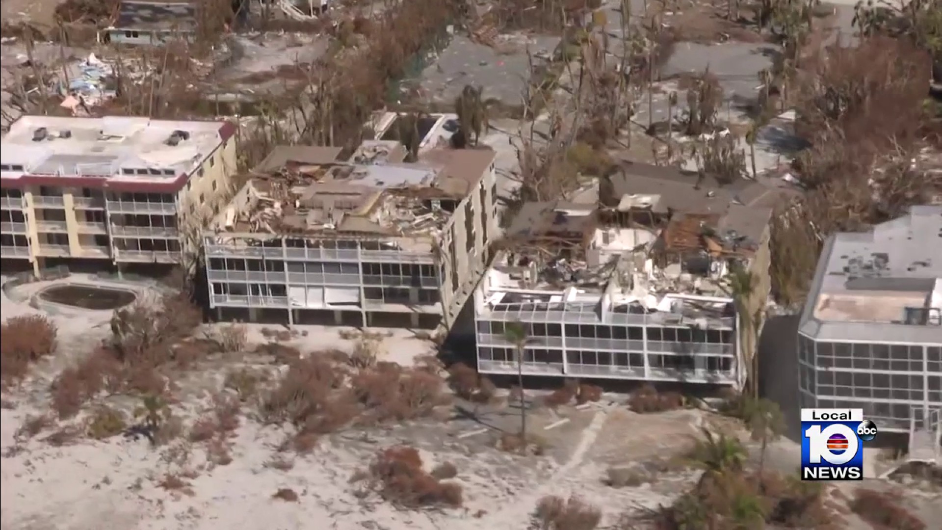
I think wind damage was to structures would have been a lot worse on top of it in a Tampa landfall despite weaker. For example this hotel, Condo on Sanibel had catastrophic wind damage. At first landfall the weaker eastern side of Ian was still pretty potent. Severe storms surge cam 5 survived most of the eastern eyewall and those winds still looked 140 on the eastern side that hit Sanibel. Was pretty dramatic footage. Sanibel those structures are pre andrew and the wind damage really showed on them. Unsurviveable on the 3rd story if you were running from the surge.

Scene like this in the Tampa area would be common to those older buildings, especially if it was a strong cat3.

Image 
4 likes   

User avatar
REDHurricane
Tropical Storm
Tropical Storm
Posts: 207
Age: 26
Joined: Sun Jul 03, 2022 2:36 pm
Location: Northeast Pacific Ocean

Re: 2023 Indicators (SST, SAL, MSLP, Wind shear, Steering, Instability) and Day 16+ Models

#1642 Postby REDHurricane » Thu Sep 21, 2023 10:24 pm


Yep, I don't see any reason why the Atlantic won't keep producing significant hurricanes during the two and a half months (10 weeks) remaining until November 30. The climatological peak of the hurricane season was just 11 days ago. The SSTs throughout the Caribbean/Gulf/Atlantic -- other than a relatively small area of cooler water carved out by Lee and Franklin in the subtropics near Bermuda -- are still extremely, anomalously warm, especially in the areas where hurricanes typically like to form in October/November. Essentially the entire Caribbean and southwest Atlantic are still at or above 30ºC, and the El Niño in all likelihood is not going to put a lid on tropical activity like it usually does. This hurricane season is definitely not close to being finished yet, and I think it's somewhat shortsighted to think otherwise at this point.

Image
0 likes   

User avatar
WalterWhite
Category 1
Category 1
Posts: 311
Joined: Fri Mar 17, 2023 5:53 pm

Re: 2023 Indicators (SST, SAL, MSLP, Wind shear, Steering, Instability) and Day 16+ Models

#1643 Postby WalterWhite » Fri Sep 22, 2023 5:20 am


No matter how warm the MDR is, we are not getting Cape Verde hurricanes in November. I could see October but definitely not November. Not even 2005 or 2020 had Cape Verde hurricanes in November.
1 likes   

User avatar
WalterWhite
Category 1
Category 1
Posts: 311
Joined: Fri Mar 17, 2023 5:53 pm

Re: 2023 Indicators (SST, SAL, MSLP, Wind shear, Steering, Instability) and Day 16+ Models

#1644 Postby WalterWhite » Fri Sep 22, 2023 5:48 am

The Atlantic right now:

2022 (La Niña plus very warm Atlantic): I'll make you below-average!

2023 (Strong El Niño plus very warm Atlantic): And I'll make you above-average!
1 likes   

User avatar
Hurricane2022
Category 4
Category 4
Posts: 944
Joined: Tue Aug 23, 2022 11:38 pm
Location: Araçatuba, Brazil

Re: 2023 Indicators (SST, SAL, MSLP, Wind shear, Steering, Instability) and Day 16+ Models

#1645 Postby Hurricane2022 » Fri Sep 22, 2023 6:07 am

WalterWhite wrote:


No matter how warm the MDR is, we are not getting Cape Verde hurricanes in November. I could see October but definitely not November. Not even 2005 or 2020 had Cape Verde hurricanes in November.

Remember the record warm SSTs. :D
0 likes   
Sorry for the bad English sometimes...!
For reliable and detailed information for any meteorological phenomenon, please consult the National Hurricane Center, Joint Typhoon Warning Center , or your local Meteo Center.

--------

Una cvm Christo, pro Christo, et in Christo. Sit nomen Domini benedictvm.

User avatar
CyclonicFury
Category 5
Category 5
Posts: 1975
Age: 25
Joined: Sun Jul 02, 2017 12:32 pm
Location: NC
Contact:

Re: 2023 Indicators (SST, SAL, MSLP, Wind shear, Steering, Instability) and Day 16+ Models

#1646 Postby CyclonicFury » Fri Sep 22, 2023 10:08 am

1 likes   
NCSU B.S. in Meteorology Class of 2021. Tropical weather blogger at http://www.cyclonicfury.com. My forecasts and thoughts are NOT official, for official forecasts please consult the National Hurricane Center.

al78
Professional-Met
Professional-Met
Posts: 249
Joined: Thu Nov 01, 2018 12:20 pm

Re: 2023 Indicators (SST, SAL, MSLP, Wind shear, Steering, Instability) and Day 16+ Models

#1647 Postby al78 » Fri Sep 22, 2023 10:59 am

Ianswfl wrote:
al78 wrote:
IcyTundra wrote:Very true Ike was bad enough as it was but no where close to what a worse case scenario what look like for the Houston/Galveston area. South Florida and Houston/Galveston have been very lucky with major hurricanes over these last several decades. There hasn't been a major hurricane landfall in Galvestion since 1983 with Alicia and for Southeast Florida they haven't been hit from the east with a major since Jeanne in 2004.


As destructive as Ian was last year I still think Florida somewhat dodged a bullet. Had Ian followed earlier predictions and tracked further north, it could have sent a huge storm surge into Tampa Bay which would probably be much worse in terms of damage and death toll than what actually happened, bearing in mind Tampa has not had a major storm surge event for a long time and residents have no experience of such an event.


Had Ian made landfall in Tampa it probably would have only been a 120-125mph storm due to increased land interaction and drier air. However, since a lot of the buildings up there are older and pre hurricane Andrew and Charley do you think the wind damage to structures would have been worse as well?


I'm not familiar with the building codes and resiliance of structures to major hurricane winds but my thinking is that even if a Tampa landfall would have been weaker than what was observed, if the hurricane maintained cat 4 winds at sea whilst approaching Tampa and the peak winds were aligned optimally to funnel water into the bay, the storm surge around Tampa and St Petersburg could have reached 15-20 feet. There are a lot of very expensive homes around there built right up to the waterfront protected only by a very modest seawall, so a major surge event would see those homes wrecked i.e. big insurance loss.
0 likes   

User avatar
cycloneye
Admin
Admin
Posts: 139310
Age: 67
Joined: Thu Oct 10, 2002 10:54 am
Location: San Juan, Puerto Rico

Re: 2023 Indicators (SST, SAL, MSLP, Wind shear, Steering, Instability) and Day 16+ Models

#1648 Postby cycloneye » Fri Sep 22, 2023 1:09 pm

3 likes   
Visit the Caribbean-Central America Weather Thread where you can find at first post web cams,radars
and observations from Caribbean basin members Click Here

User avatar
WalterWhite
Category 1
Category 1
Posts: 311
Joined: Fri Mar 17, 2023 5:53 pm

Re: 2023 Indicators (SST, SAL, MSLP, Wind shear, Steering, Instability) and Day 16+ Models

#1649 Postby WalterWhite » Fri Sep 22, 2023 2:43 pm

Hurricane2022 wrote:
WalterWhite wrote:


No matter how warm the MDR is, we are not getting Cape Verde hurricanes in November. I could see October but definitely not November. Not even 2005 or 2020 had Cape Verde hurricanes in November.

Remember the record warm SSTs. :D


Has there ever been a Cape Verde hurricane recorded in November?
0 likes   

User avatar
CyclonicFury
Category 5
Category 5
Posts: 1975
Age: 25
Joined: Sun Jul 02, 2017 12:32 pm
Location: NC
Contact:

Re: 2023 Indicators (SST, SAL, MSLP, Wind shear, Steering, Instability) and Day 16+ Models

#1650 Postby CyclonicFury » Fri Sep 22, 2023 2:50 pm

WalterWhite wrote:
Hurricane2022 wrote:
WalterWhite wrote:
No matter how warm the MDR is, we are not getting Cape Verde hurricanes in November. I could see October but definitely not November. Not even 2005 or 2020 had Cape Verde hurricanes in November.

Remember the record warm SSTs. :D


Has there ever been a Cape Verde hurricane recorded in November?

I can't think of any in the satellite era, but I can think of some hurricanes that formed from AEWs in November. Kate 1985, Kate 2015 and Iota 2020 are some examples.
0 likes   
NCSU B.S. in Meteorology Class of 2021. Tropical weather blogger at http://www.cyclonicfury.com. My forecasts and thoughts are NOT official, for official forecasts please consult the National Hurricane Center.

User avatar
WalterWhite
Category 1
Category 1
Posts: 311
Joined: Fri Mar 17, 2023 5:53 pm

Re: 2023 Indicators (SST, SAL, MSLP, Wind shear, Steering, Instability) and Day 16+ Models

#1651 Postby WalterWhite » Fri Sep 22, 2023 2:54 pm

CyclonicFury wrote:
WalterWhite wrote:
Hurricane2022 wrote:Remember the record warm SSTs. :D


Has there ever been a Cape Verde hurricane recorded in November?

I can't think of any in the satellite era, but I can think of some hurricanes that formed from AEWs in November. Kate 1985, Kate 2015 and Iota 2020 are some examples.


That could certainly happen this November, but I still highly doubt it is realistic to presume we might see a bona fide Cape Verde hurricane in November (i.e. one that forms east of 40 W).
Last edited by WalterWhite on Fri Sep 22, 2023 2:58 pm, edited 1 time in total.
0 likes   

Sciencerocks
Category 5
Category 5
Posts: 7287
Age: 38
Joined: Thu Jul 06, 2017 1:51 am

Re: 2023 Indicators (SST, SAL, MSLP, Wind shear, Steering, Instability) and Day 16+ Models

#1652 Postby Sciencerocks » Fri Sep 22, 2023 2:56 pm

I am starting to suspect that global warming is starting to make the difference
 https://twitter.com/Lijing_Cheng/status/1705232940316418202


5 likes   

User avatar
REDHurricane
Tropical Storm
Tropical Storm
Posts: 207
Age: 26
Joined: Sun Jul 03, 2022 2:36 pm
Location: Northeast Pacific Ocean

Re: 2023 Indicators (SST, SAL, MSLP, Wind shear, Steering, Instability) and Day 16+ Models

#1653 Postby REDHurricane » Fri Sep 22, 2023 11:26 pm

Sciencerocks wrote:I am starting to suspect that global warming is starting to make the difference
https://twitter.com/Lijing_Cheng/status/1705232940316418202


How extraordinary and utterly terrifying it is to see the entire Earth's climate irreversibly transform right before our eyes... literally hundreds, if not thousands, of years' worth of change to our planet taking place within the span of mere decades, and there's nothing that we can do except watch the chaos unfold
:blowup:
10 likes   

User avatar
WalterWhite
Category 1
Category 1
Posts: 311
Joined: Fri Mar 17, 2023 5:53 pm

Re: 2023 Indicators (SST, SAL, MSLP, Wind shear, Steering, Instability) and Day 16+ Models

#1654 Postby WalterWhite » Sat Sep 23, 2023 6:35 am


That is actually pretty normal for El Niños. El Niños generally have rising air over the Americans, and La Niñás generally have rising air over the Indian Ocean.
2 likes   

WeatherBoy2000
Tropical Depression
Tropical Depression
Posts: 93
Joined: Mon Apr 10, 2023 9:29 am

Re: 2023 Indicators (SST, SAL, MSLP, Wind shear, Steering, Instability) and Day 16+ Models

#1655 Postby WeatherBoy2000 » Sat Sep 23, 2023 8:44 am

REDHurricane wrote:
Sciencerocks wrote:I am starting to suspect that global warming is starting to make the difference
https://twitter.com/Lijing_Cheng/status/1705232940316418202


How extraordinary and utterly terrifying it is to see the entire Earth's climate irreversibly transform right before our eyes... literally hundreds, if not thousands, of years' worth of change to our planet taking place within the span of mere decades, and there's nothing that we can do except watch the chaos unfold
:blowup:


Imo global warming will continue to make <100 ace Atlantic hurricane seasons rarer and rarer. The downtrend is already happening, 1990s had 6, 2000s had 4, and the 2010s only had 3. Admittedly the 70s through the early 90s was an inactive period, but even in the 1930s-60s there weren't 6 year streaks of 130+ ace seasons (2016-2021). 2022 was only barely below 100 ace despite having record inactivity from June-August. A strong el nino is unlikely to prevent the season from achieving at least 130 ace, which is unprecedented in the modern record. As time goes forward, there is going to continue to be more energy out there for TCs to tap into which will allow them to strengthen stronger, quicker, and to be longer lived.
2 likes   

Ianswfl
Category 1
Category 1
Posts: 482
Joined: Thu Mar 23, 2023 11:11 pm

Re: 2023 Indicators (SST, SAL, MSLP, Wind shear, Steering, Instability) and Day 16+ Models

#1656 Postby Ianswfl » Sat Sep 23, 2023 8:55 am

WeatherBoy2000 wrote:
REDHurricane wrote:
Sciencerocks wrote:I am starting to suspect that global warming is starting to make the difference
https://twitter.com/Lijing_Cheng/status/1705232940316418202


How extraordinary and utterly terrifying it is to see the entire Earth's climate irreversibly transform right before our eyes... literally hundreds, if not thousands, of years' worth of change to our planet taking place within the span of mere decades, and there's nothing that we can do except watch the chaos unfold
:blowup:


Imo global warming will continue to make <100 ace Atlantic hurricane seasons rarer and rarer. The downtrend is already happening, 1990s had 6, 2000s had 4, and the 2010s only had 3. Admittedly the 70s through the early 90s was an inactive period, but even in the 1930s-60s there weren't 6 year streaks of 130+ ace seasons (2016-2021). 2022 was only barely below 100 ace despite having record inactivity from June-August. A strong el nino is unlikely to prevent the season from achieving at least 130 ace, which is unprecedented in the modern record. As time goes forward, there is going to continue to be more energy out there for TCs to tap into which will allow them to strengthen stronger, quicker, and to be longer lived.


You think the gulf will be more active in nov due to warmer temps?
1 likes   

User avatar
cheezyWXguy
Category 5
Category 5
Posts: 5556
Joined: Mon Feb 13, 2006 12:29 am
Location: Dallas, TX

Re: 2023 Indicators (SST, SAL, MSLP, Wind shear, Steering, Instability) and Day 16+ Models

#1657 Postby cheezyWXguy » Sat Sep 23, 2023 9:38 am

WeatherBoy2000 wrote:
REDHurricane wrote:
Sciencerocks wrote:I am starting to suspect that global warming is starting to make the difference
https://twitter.com/Lijing_Cheng/status/1705232940316418202


How extraordinary and utterly terrifying it is to see the entire Earth's climate irreversibly transform right before our eyes... literally hundreds, if not thousands, of years' worth of change to our planet taking place within the span of mere decades, and there's nothing that we can do except watch the chaos unfold
:blowup:


REDHurricane wrote:
Sciencerocks wrote:I am starting to suspect that global warming is starting to make the difference
https://twitter.com/Lijing_Cheng/status/1705232940316418202


How extraordinary and utterly terrifying it is to see the entire Earth's climate irreversibly transform right before our eyes... literally hundreds, if not thousands, of years' worth of change to our planet taking place within the span of mere decades, and there's nothing that we can do except watch the chaos unfold
:blowup:


Imo global warming will continue to make <100 ace Atlantic hurricane seasons rarer and rarer. The downtrend is already happening, 1990s had 6, 2000s had 4, and the 2010s only had 3. Admittedly the 70s through the early 90s was an inactive period, but even in the 1930s-60s there weren't 6 year streaks of 130+ ace seasons (2016-2021). 2022 was only barely below 100 ace despite having record inactivity from June-August. A strong el nino is unlikely to prevent the season from achieving at least 130 ace, which is unprecedented in the modern record. As time goes forward, there is going to continue to be more energy out there for TCs to tap into which will allow them to strengthen stronger, quicker, and to be longer lived.

While I agree global warming could have an impact on this, analysis of this is muddied by a third variable problem: lack of detection during the pre-satellite era and a relatively short period of tc record keeping in general (~150 years). The next decade or two should prove very valuable in determining the correlation between ssts and tc activity in spite of enso, with this year obviously being one of the first to dig into
2 likes   

WeatherBoy2000
Tropical Depression
Tropical Depression
Posts: 93
Joined: Mon Apr 10, 2023 9:29 am

Re: 2023 Indicators (SST, SAL, MSLP, Wind shear, Steering, Instability) and Day 16+ Models

#1658 Postby WeatherBoy2000 » Sat Sep 23, 2023 10:52 am

cheezyWXguy wrote:
WeatherBoy2000 wrote:
REDHurricane wrote:
How extraordinary and utterly terrifying it is to see the entire Earth's climate irreversibly transform right before our eyes... literally hundreds, if not thousands, of years' worth of change to our planet taking place within the span of mere decades, and there's nothing that we can do except watch the chaos unfold
:blowup:


Imo global warming will continue to make <100 ace Atlantic hurricane seasons rarer and rarer. The downtrend is already happening, 1990s had 6, 2000s had 4, and the 2010s only had 3. Admittedly the 70s through the early 90s was an inactive period, but even in the 1930s-60s there weren't 6 year streaks of 130+ ace seasons (2016-2021). 2022 was only barely below 100 ace despite having record inactivity from June-August. A strong el nino is unlikely to prevent the season from achieving at least 130 ace, which is unprecedented in the modern record. As time goes forward, there is going to continue to be more energy out there for TCs to tap into which will allow them to strengthen stronger, quicker, and to be longer lived.

While I agree global warming could have an impact on this, analysis of this is muddied by a third variable problem: lack of detection during the pre-satellite era and a relatively short period of tc record keeping in general (~150 years). The next decade or two should prove very valuable in determining the correlation between ssts and tc activity in spite of enso, with this year obviously being one of the first to dig into


Yeah we'll ultimately have to wait and see. Imo the continued warming of the basin should allow storms to get more powerful and to last longer compared to the past, both good for accumulating ace. I think I read a study somewhere that claims AGW would result in a reduction of storms worldwide but the ones that do form will generally be stronger. We may see fewer storms but higher ace.
1 likes   

tolakram
Admin
Admin
Posts: 19171
Age: 60
Joined: Sun Aug 27, 2006 8:23 pm
Location: Florence, KY (name is Mark)

Re: 2023 Indicators (SST, SAL, MSLP, Wind shear, Steering, Instability) and Day 16+ Models

#1659 Postby tolakram » Sat Sep 23, 2023 11:56 am

Look back during the major hurricane drought. Same thing, just different. Everyone is convinced something has changed and everything will be different, and yet the same as it is now. These posts will look foolish a few years from now, just like 2013 redo predictions look foolish at the start of a busy season.

Predict slow season, get strong season, overreact.
Predict strong season, get slow season, overreact.

Works well on social media only. :lol:
6 likes   
M a r k
- - - - -
Join us in chat: Storm2K Chatroom Invite. Android and IOS apps also available.

The posts in this forum are NOT official forecasts and should not be used as such. Posts are NOT endorsed by any professional institution or STORM2K.org. For official information and forecasts, please refer to NHC and NWS products.

User avatar
WalterWhite
Category 1
Category 1
Posts: 311
Joined: Fri Mar 17, 2023 5:53 pm

Re: 2023 Indicators (SST, SAL, MSLP, Wind shear, Steering, Instability) and Day 16+ Models

#1660 Postby WalterWhite » Sat Sep 23, 2023 2:29 pm

Tropical Depression 17L has been upgraded to Tropical Storm Philippe according to the latest best track update. That brings the 2023 Atlantic Hurricane Season to 17 storms.

Only 3 seasons have had 17 or more storms by September 23: 2005, 2020, and 2021. The big question now is how the late season progresses. If the late season progresses in a similar fashion to 2005 or 2020, the 2023 Atlantic Hurricane Season would likely be hyperactive. If it progresses in a similar fashion to 2021, the 2023 Atlantic Hurricane Season would almost certainly not become hyperactive.

Moreover, if the season were to follow climatology from here until the end of year, the season would end with 21 storms, 9 hurricanes, and 4 major hurricanes. This season has exceeded climatology so far, so we could realistically see higher statistics in all three of those categories.
0 likes   


Return to “Talkin' Tropics”

Who is online

Users browsing this forum: cainjamin, Google Adsense [Bot], Gums, KirbyDude25, Lizzytiz1, Stratton23 and 137 guests