2023 Indicators (SST, SAL, MSLP, Wind shear, Steering, Instability) and Day 16+ Models

This is the general tropical discussion area. Anyone can take their shot at predicting a storms path.

Moderator: S2k Moderators

Forum rules

The posts in this forum are NOT official forecasts and should not be used as such. They are just the opinion of the poster and may or may not be backed by sound meteorological data. They are NOT endorsed by any professional institution or STORM2K. For official information, please refer to products from the National Hurricane Center and National Weather Service.

Help Support Storm2K
Message
Author
User avatar
REDHurricane
Tropical Storm
Tropical Storm
Posts: 207
Age: 26
Joined: Sun Jul 03, 2022 2:36 pm
Location: Northeast Pacific Ocean

Re: 2023 Indicators (SST, SAL, MSLP, Wind shear, Steering, Instability) and Day 16+ Models

#1661 Postby REDHurricane » Sat Sep 23, 2023 2:33 pm

tolakram wrote:Look back during the major hurricane drought. Same thing, just different. Everyone is convinced something has changed and everything will be different, and yet the same as it is now. These posts will look foolish a few years from now, just like 2013 redo predictions look foolish at the start of a busy season.

Predict slow season, get strong season, overreact.
Predict strong season, get slow season, overreact.

Works well on social media only. :lol:


While it is a mistake to make sweeping generalizations about the future based on the results of any individual hurricane season, it is an equally significant mistake to ignore clear evidence that tropical cyclone frequency/intensity is trending a certain direction over the span of decades, especially when there is an obvious and measurable scientific explanation behind the trend's existence. Yeah, our limited historical TC data beyond the past ~100 years makes it impossible to know precisely to what extent tropical activity on Earth has typically fluctuated on a century-to-century basis, but it doesn't take a PhD in climate science to realize that record high (and still rising) global SSTs are probably going to lead to a notable increase in the length/strength of the average hurricane season as time goes on.
Last edited by REDHurricane on Sat Sep 23, 2023 3:32 pm, edited 2 times in total.
3 likes   

User avatar
weeniepatrol
Category 3
Category 3
Posts: 866
Joined: Sat Aug 22, 2020 5:30 pm
Location: WA State

Re: 2023 Indicators (SST, SAL, MSLP, Wind shear, Steering, Instability) and Day 16+ Models

#1662 Postby weeniepatrol » Sat Sep 23, 2023 2:47 pm

We are getting uncomfortably low on names.

Imagine we exhaust the list - during a strengthening El Nino. :lol: :lol:

it's only 23 September btw!!!
7 likes   

User avatar
Category5Kaiju
Category 5
Category 5
Posts: 3399
Age: 22
Joined: Thu Dec 24, 2020 12:45 pm
Location: Seattle

Re: 2023 Indicators (SST, SAL, MSLP, Wind shear, Steering, Instability) and Day 16+ Models

#1663 Postby Category5Kaiju » Sat Sep 23, 2023 3:07 pm

weeniepatrol wrote:We are getting uncomfortably low on names.

Imagine we exhaust the list - during a strengthening El Nino. :lol: :lol:

it's only 23 September btw!!!


Atlantic was really like "El Nino my ass" this year lol
7 likes   
Unless explicitly stated, all information covered in my posts is based on my opinions and observations. Please refer to a professional meteorologist or an accredited weather research agency otherwise, especially if serious decisions must be made in the event of a potentially life-threatening tropical storm or hurricane.

User avatar
WalterWhite
Category 1
Category 1
Posts: 311
Joined: Fri Mar 17, 2023 5:53 pm

Re: 2023 Indicators (SST, SAL, MSLP, Wind shear, Steering, Instability) and Day 16+ Models

#1664 Postby WalterWhite » Sat Sep 23, 2023 3:15 pm

The fact that Idalia, a major hurricane, formed from the Central American Gyre in August makes me think the peak Central American Gyre season, which is usually in October, will be pretty active. Additionally, wind shear in the Western Atlantic has been near-average despite the El Niño, and SSTs in that region of the Atlantic are well above-average, with most of the Gulf of Mexico and the Caribbean at or above 30 degrees Celsius. I would not be surprised if we get multiple major hurricanes originating from the Central American Gyre during October and November.

Major hurricanes in August usually form from tropical waves. In 2021, Grace and Ida formed from tropical waves originating from East Africa. In 2020, Laura formed from a tropical wave originating from East Africa. The same applies to Dorian (2019); Harvey (2017); Gaston (2016); Danny (2015); Irene (2011); Danielle and Earl (2010); Bill (2009); Gustav (2008); Dean (2007); Katrina (2005); Alex, Charley, and Frances (2004); Fabian (2003); Alberto (2000); Bret and Cindy (1999); Bonnie (1998); Edouard and Fran (1996); Felix and Luis (1995); Emily (1993); Andrew (1992); Gustav (1990); Elena (1985); Allen (1980); David (1979); Anita (1977); Belle and Frances (1976); Carolina (1975); Celia (1970); and Camille and Debbie (1969). Bob (1991), Alicia (1983), and Becky (1974) all originated from non-tropical origins.

In other words, Major Hurricane Idalia (2023) is the first August major hurricane formed from the Central American Gyre in this satellite era. Because climatology dictates that the Central American Gyre usually peaks in October, we could see enhanced Central American Gyre activity during the late season.

With this in mind, October could be a very destructive month for this hurricane season. Major hurricanes in either the Gulf of Mexico and the Caribbean always bring destruction somewhere (whether it is Florida, Louisiana, Texas, Hispaniola, or Central America).
1 likes   

User avatar
cycloneye
Admin
Admin
Posts: 139311
Age: 67
Joined: Thu Oct 10, 2002 10:54 am
Location: San Juan, Puerto Rico

Re: 2023 Indicators (SST, SAL, MSLP, Wind shear, Steering, Instability) and Day 16+ Models

#1665 Postby cycloneye » Sat Sep 23, 2023 4:58 pm

0 likes   
Visit the Caribbean-Central America Weather Thread where you can find at first post web cams,radars
and observations from Caribbean basin members Click Here

User avatar
aspen
Category 5
Category 5
Posts: 8057
Joined: Sat Oct 12, 2019 7:10 pm
Location: Connecticut, USA

Re: 2023 Indicators (SST, SAL, MSLP, Wind shear, Steering, Instability) and Day 16+ Models

#1666 Postby aspen » Sat Sep 23, 2023 5:08 pm

weeniepatrol wrote:We are getting uncomfortably low on names.

Imagine we exhaust the list - during a strengthening El Nino. :lol: :lol:

it's only 23 September btw!!!

We’re probably hitting 20 NS at this rate, unless we see a near-total shutdown of activity after September, which I think could be possible. The ocean and atmo have to synch up eventually.
0 likes   
Irene '11 Sandy '12 Hermine '16 5/15/2018 Derecho Fay '20 Isaias '20 Elsa '21 Henri '21 Ida '21

I am only a meteorology enthusiast who knows a decent amount about tropical cyclones. Look to the professional mets, the NHC, or your local weather office for the best information.

User avatar
Teban54
Category 5
Category 5
Posts: 1973
Joined: Sat May 19, 2018 1:19 pm

Re: 2023 Indicators (SST, SAL, MSLP, Wind shear, Steering, Instability) and Day 16+ Models

#1667 Postby Teban54 » Sat Sep 23, 2023 5:43 pm

What's more impressive than the number of storms alone is that their qualities aren't lacking.

The 12 storms that formed since August 20 this year were 12/5/3, whereas the ones in 2020 were 12/6/2. Many forum members here believe that Jose and Ophelia could have been unofficial hurricanes, which would have brought the total to 12/7/3.

We've had a Cat 5 (which 2020 lacked), a 130 kt Cat 4 that nobody expected to happen, and yet another Gulf RI'ing Cat 4. We had 3 classic CV storms that became hurricanes this year, while 2020 had 2. Even many of the (official) TSes were memorable: Gert somehow managed to hang around forever and outlive all 5 other August storms, Jose had dual rotating hot towers and might have been one of the smallest hurricanes on record, and Ophelia went from a frontal low to almost a hurricane in the blink of an eye.

These 12 storms have generated 101.6 ACE to date, and Philippe's story has only just begun. Those 12 storms in 2020 generated about 81.4 ACE. (I used CSU for 2023 and Ryan Maue's website for 2020, so there could be some inaccuracies.)

The fact that an El Nino year is even comparable in some capacity to the most active season on record at all is bonkers.
10 likes   

al78
Professional-Met
Professional-Met
Posts: 249
Joined: Thu Nov 01, 2018 12:20 pm

Re: 2023 Indicators (SST, SAL, MSLP, Wind shear, Steering, Instability) and Day 16+ Models

#1668 Postby al78 » Sun Sep 24, 2023 3:45 am

aspen wrote:
weeniepatrol wrote:We are getting uncomfortably low on names.

Imagine we exhaust the list - during a strengthening El Nino. :lol: :lol:

it's only 23 September btw!!!

We’re probably hitting 20 NS at this rate, unless we see a near-total shutdown of activity after September, which I think could be possible. The ocean and atmo have to synch up eventually.


Normally during a moderate or strong El Nino I would expect activity to die off as we go into October given the typical high wind shear over the Caribbean Sea seen during El Nino events. This year the Atlantic hurricane season seems to have little interest in El Nino given the atmosphere/Walker circulation has not exhibited a typical response so who knows what the near future holds.
0 likes   

al78
Professional-Met
Professional-Met
Posts: 249
Joined: Thu Nov 01, 2018 12:20 pm

Re: 2023 Indicators (SST, SAL, MSLP, Wind shear, Steering, Instability) and Day 16+ Models

#1669 Postby al78 » Sun Sep 24, 2023 3:51 am

REDHurricane wrote:
tolakram wrote:Look back during the major hurricane drought. Same thing, just different. Everyone is convinced something has changed and everything will be different, and yet the same as it is now. These posts will look foolish a few years from now, just like 2013 redo predictions look foolish at the start of a busy season.

Predict slow season, get strong season, overreact.
Predict strong season, get slow season, overreact.

Works well on social media only. :lol:


While it is a mistake to make sweeping generalizations about the future based on the results of any individual hurricane season, it is an equally significant mistake to ignore clear evidence that tropical cyclone frequency/intensity is trending a certain direction over the span of decades, especially when there is an obvious and measurable scientific explanation behind the trend's existence. Yeah, our limited historical TC data beyond the past ~100 years makes it impossible to know precisely to what extent tropical activity on Earth has typically fluctuated on a century-to-century basis, but it doesn't take a PhD in climate science to realize that record high (and still rising) global SSTs are probably going to lead to a notable increase in the length/strength of the average hurricane season as time goes on.


If SSTs continue to warm in the coming decades it depends on how the atmosphere responds, but I would expect an upward trend in rapid intensification events and numbers of cat 4/5 tropical cyclones (although it will be hard to detect this at least initially due to the small numbers climatologically), even if the atmosphere becomes more hostile on average. There will still be ENSO and periods when atmospheric conditions are optimal, and it only takes a vigorous tropical wave in the right place at the right time to get a Cat 5.
0 likes   

User avatar
kevin
Category 5
Category 5
Posts: 1770
Age: 25
Joined: Wed Aug 28, 2019 4:35 am

Re: 2023 Indicators (SST, SAL, MSLP, Wind shear, Steering, Instability) and Day 16+ Models

#1670 Postby kevin » Sun Sep 24, 2023 9:01 am

So far the 2023 open ocean MDR/CV season is incredible. Here an overview of how many MDR storms we've had since 2000. Here I count the MDR as everything west of the islands (so not the Caribbean) and between 10N and 20N. The system must've at least been a TD before reaching the islands (60W) to count. With 10 MDR storms 2023 has the most MDR storms of any season since at least 2000 (haven't checked before that) and the season isn't even over yet. And also after 2004 it has the highest percentage of MDR storms. 2005 for example was very active, but had an almost non-existent MDR with more activity in the WCar and the Gulf. The same goes for last year. The only thing that 2023 is still lacking is a high hurricane or MH count in the MDR like 2004. However, with Philippe and 91L it's not out of the question that we'll at least get 5 MDR hurricanes this season.

Year / MDR TS / MDR HU / MDR MH / MDR C5 / Percentage of all storms

2023 / 10 / 3 / 1 / 1 / 59%
2022 / 3 / 2 / 1 / 0 / 21%
2021 / 8 / 4 / 3 / 0 / 38%
2020 / 9 / 4 / 2 / 0 / 30%
2019 / 6 / 3 / 2 / 2 / 33%
2018 / 6 / 4 / 1 / 0 / 40%
2017 / 6 / 5 / 4 / 2 / 35%
2016 / 6 / 2 / 1 / 1 / 38%
2015 / 5 / 2 / 1 / 0 / 45%
2014 / 3 / 3 / 2 / 0 / 38%
2013 / 4 / 1 / 0 / 0 / 29%
2012 / 9 / 4 / 0 / 0 / 47%
2011 / 5 / 5 / 3 / 0 / 26%
2010 / 9 / 6 / 4 / 0 / 47%
2009 / 5 / 2 / 2 / 0 / 56%
2008 / 5 / 3 / 2 / 0 / 31%
2007 / 5 / 3 / 2 / 2 / 33%
2006 / 5 / 3 / 2 / 0 / 50%
2005 / 5 / 4 / 2 / 1 / 18%
2004 / 9 / 7 / 5 / 1 / 60%
2003 / 6 / 4 / 3 / 1 / 38%
2002 / 2 / 1 / 1 / 0 / 17%
2001 / 5 / 3 / 3 / 0 / 33%
2000 / 7 / 4 / 2 / 0 / 47%
Average / 6 / 3 / 2 / 0
10 likes   

User avatar
WalterWhite
Category 1
Category 1
Posts: 311
Joined: Fri Mar 17, 2023 5:53 pm

Re: 2023 Indicators (SST, SAL, MSLP, Wind shear, Steering, Instability) and Day 16+ Models

#1671 Postby WalterWhite » Mon Sep 25, 2023 4:47 am

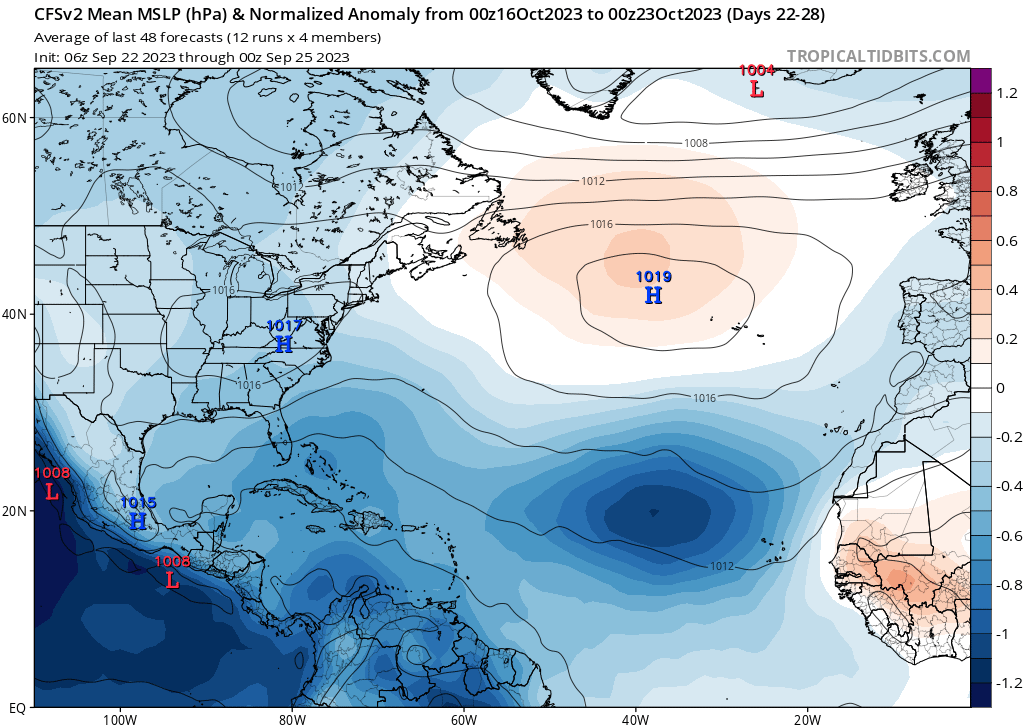
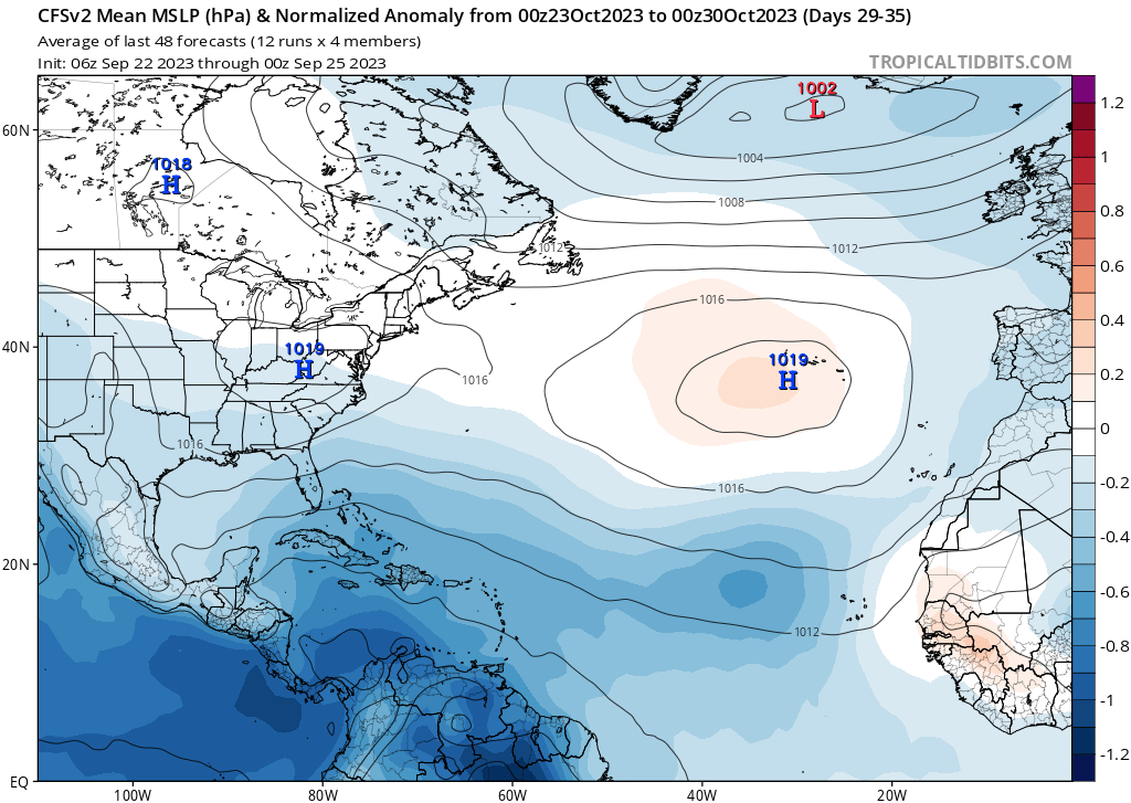
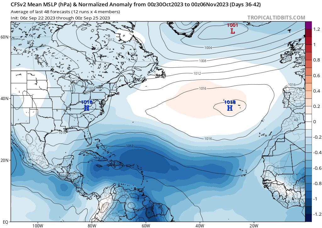
The CFSv2 is indicating below-average MSLPs throughout the tropical Atlantic during the entirely of October and the first half of November.

Image

Image

Image

Image

Lower MSLPs throughout the tropical Atlantic generally indicate favorable conditions, so this hurricane season could realistically run until mid-November.
1 likes   

User avatar
Category5Kaiju
Category 5
Category 5
Posts: 3399
Age: 22
Joined: Thu Dec 24, 2020 12:45 pm
Location: Seattle

Re: 2023 Indicators (SST, SAL, MSLP, Wind shear, Steering, Instability) and Day 16+ Models

#1672 Postby Category5Kaiju » Mon Sep 25, 2023 7:03 am

WalterWhite wrote:The CFSv2 is indicating below-average MSLPs throughout the tropical Atlantic during the entirely of October and the first half of November.

https://i.postimg.cc/k5CVKbJG/cfs-avg-mslpa-Norm-Mean-atl-3.png

https://i.postimg.cc/FRW1MCjk/cfs-avg-mslpa-Norm-Mean-atl-4.png

https://i.postimg.cc/j2DCt6Xg/cfs-avg-mslpa-Norm-Mean-atl-5.png

https://i.postimg.cc/0jhjQ6X8/cfs-avg-mslpa-Norm-Mean-atl-6.png

Lower MSLPs throughout the tropical Atlantic generally indicate favorable conditions, so this hurricane season could realistically run until mid-November.


2023 about to hit the auxiliary list (or basically what used to be the Greek alphabet) during a moderate El Nino year :lol:
0 likes   
Unless explicitly stated, all information covered in my posts is based on my opinions and observations. Please refer to a professional meteorologist or an accredited weather research agency otherwise, especially if serious decisions must be made in the event of a potentially life-threatening tropical storm or hurricane.

MarioProtVI
Category 2
Category 2
Posts: 671
Age: 22
Joined: Sun Sep 29, 2019 7:33 pm
Location: New Jersey

Re: 2023 Indicators (SST, SAL, MSLP, Wind shear, Steering, Instability) and Day 16+ Models

#1673 Postby MarioProtVI » Mon Sep 25, 2023 11:27 am

kevin wrote:So far the 2023 open ocean MDR/CV season is incredible. Here an overview of how many MDR storms we've had since 2000. Here I count the MDR as everything west of the islands (so not the Caribbean) and between 10N and 20N. The system must've at least been a TD before reaching the islands (60W) to count. With 10 MDR storms 2023 has the most MDR storms of any season since at least 2000 (haven't checked before that) and the season isn't even over yet. And also after 2004 it has the highest percentage of MDR storms. 2005 for example was very active, but had an almost non-existent MDR with more activity in the WCar and the Gulf. The same goes for last year. The only thing that 2023 is still lacking is a high hurricane or MH count in the MDR like 2004. However, with Philippe and 91L it's not out of the question that we'll at least get 5 MDR hurricanes this season.

Year / MDR TS / MDR HU / MDR MH / MDR C5 / Percentage of all storms

2023 / 10 / 3 / 1 / 1 / 59%
2022 / 3 / 2 / 1 / 0 / 21%
2021 / 8 / 4 / 3 / 0 / 38%
2020 / 9 / 4 / 2 / 0 / 30%
2019 / 6 / 3 / 2 / 2 / 33%
2018 / 6 / 4 / 1 / 0 / 40%
2017 / 6 / 5 / 4 / 2 / 35%
2016 / 6 / 2 / 1 / 1 / 38%
2015 / 5 / 2 / 1 / 0 / 45%
2014 / 3 / 3 / 2 / 0 / 38%
2013 / 4 / 1 / 0 / 0 / 29%
2012 / 9 / 4 / 0 / 0 / 47%
2011 / 5 / 5 / 3 / 0 / 26%
2010 / 9 / 6 / 4 / 0 / 47%
2009 / 5 / 2 / 2 / 0 / 56%
2008 / 5 / 3 / 2 / 0 / 31%
2007 / 5 / 3 / 2 / 2 / 33%
2006 / 5 / 3 / 2 / 0 / 50%
2005 / 5 / 4 / 2 / 1 / 18%
2004 / 9 / 7 / 5 / 1 / 60%
2003 / 6 / 4 / 3 / 1 / 38%
2002 / 2 / 1 / 1 / 0 / 17%
2001 / 5 / 3 / 3 / 0 / 33%
2000 / 7 / 4 / 2 / 0 / 47%
Average / 6 / 3 / 2 / 0

Lee’s been the only MDR hurricane so far. Not sure where the other two are from considering the definition is 10N-20N. Maybe Bret as well if it gets a bump in TCR.
0 likes   

User avatar
kevin
Category 5
Category 5
Posts: 1770
Age: 25
Joined: Wed Aug 28, 2019 4:35 am

Re: 2023 Indicators (SST, SAL, MSLP, Wind shear, Steering, Instability) and Day 16+ Models

#1674 Postby kevin » Mon Sep 25, 2023 1:19 pm

MarioProtVI wrote:
kevin wrote:So far the 2023 open ocean MDR/CV season is incredible. Here an overview of how many MDR storms we've had since 2000. Here I count the MDR as everything west of the islands (so not the Caribbean) and between 10N and 20N. The system must've at least been a TD before reaching the islands (60W) to count. With 10 MDR storms 2023 has the most MDR storms of any season since at least 2000 (haven't checked before that) and the season isn't even over yet. And also after 2004 it has the highest percentage of MDR storms. 2005 for example was very active, but had an almost non-existent MDR with more activity in the WCar and the Gulf. The same goes for last year. The only thing that 2023 is still lacking is a high hurricane or MH count in the MDR like 2004. However, with Philippe and 91L it's not out of the question that we'll at least get 5 MDR hurricanes this season.

Year / MDR TS / MDR HU / MDR MH / MDR C5 / Percentage of all storms

2023 / 10 / 3 / 1 / 1 / 59%
2022 / 3 / 2 / 1 / 0 / 21%
2021 / 8 / 4 / 3 / 0 / 38%
2020 / 9 / 4 / 2 / 0 / 30%
2019 / 6 / 3 / 2 / 2 / 33%
2018 / 6 / 4 / 1 / 0 / 40%
2017 / 6 / 5 / 4 / 2 / 35%
2016 / 6 / 2 / 1 / 1 / 38%
2015 / 5 / 2 / 1 / 0 / 45%
2014 / 3 / 3 / 2 / 0 / 38%
2013 / 4 / 1 / 0 / 0 / 29%
2012 / 9 / 4 / 0 / 0 / 47%
2011 / 5 / 5 / 3 / 0 / 26%
2010 / 9 / 6 / 4 / 0 / 47%
2009 / 5 / 2 / 2 / 0 / 56%
2008 / 5 / 3 / 2 / 0 / 31%
2007 / 5 / 3 / 2 / 2 / 33%
2006 / 5 / 3 / 2 / 0 / 50%
2005 / 5 / 4 / 2 / 1 / 18%
2004 / 9 / 7 / 5 / 1 / 60%
2003 / 6 / 4 / 3 / 1 / 38%
2002 / 2 / 1 / 1 / 0 / 17%
2001 / 5 / 3 / 3 / 0 / 33%
2000 / 7 / 4 / 2 / 0 / 47%
Average / 6 / 3 / 2 / 0

Lee’s been the only MDR hurricane so far. Not sure where the other two are from considering the definition is 10N-20N. Maybe Bret as well if it gets a bump in TCR.


Lee, Margot and Nigel. My definition for that list is any storm which formed within the MDR, which Margot and Nigel also meet despite only reaching hurricane strength during their recurve outside of the MDR. The same goes for all years in the overview though so it's still a fair comparison.
1 likes   

User avatar
WalterWhite
Category 1
Category 1
Posts: 311
Joined: Fri Mar 17, 2023 5:53 pm

Re: 2023 Indicators (SST, SAL, MSLP, Wind shear, Steering, Instability) and Day 16+ Models

#1675 Postby WalterWhite » Mon Sep 25, 2023 7:48 pm

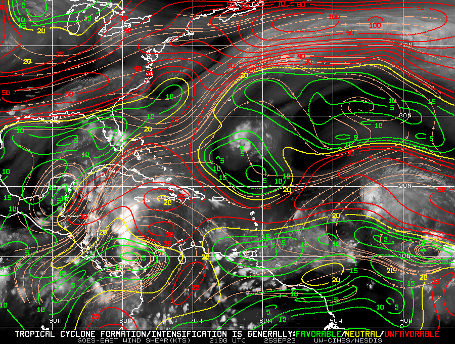
For some reason, wind shear seems to be unfavorable throughout most of the Atlantic basin.

Image
0 likes   

tolakram
Admin
Admin
Posts: 19171
Age: 60
Joined: Sun Aug 27, 2006 8:23 pm
Location: Florence, KY (name is Mark)

Re: 2023 Indicators (SST, SAL, MSLP, Wind shear, Steering, Instability) and Day 16+ Models

#1676 Postby tolakram » Mon Sep 25, 2023 8:19 pm

WalterWhite wrote:For some reason, wind shear seems to be unfavorable throughout most of the Atlantic basin.

https://i.postimg.cc/W1KW0f7p/wg8shr.gif


El Nino finally starting to win the battle. Maybe. Models show unfavorable wind shear in the future as well, but the model shear forecasts can be horribly inaccurate. If el nino does start winning I still expect a lot of storms to spin up when they find favorable spots. We shall see.
0 likes   
M a r k
- - - - -
Join us in chat: Storm2K Chatroom Invite. Android and IOS apps also available.

The posts in this forum are NOT official forecasts and should not be used as such. Posts are NOT endorsed by any professional institution or STORM2K.org. For official information and forecasts, please refer to NHC and NWS products.

User avatar
WalterWhite
Category 1
Category 1
Posts: 311
Joined: Fri Mar 17, 2023 5:53 pm

Re: 2023 Indicators (SST, SAL, MSLP, Wind shear, Steering, Instability) and Day 16+ Models

#1677 Postby WalterWhite » Mon Sep 25, 2023 8:35 pm

tolakram wrote:
WalterWhite wrote:For some reason, wind shear seems to be unfavorable throughout most of the Atlantic basin.

https://i.postimg.cc/W1KW0f7p/wg8shr.gif


El Nino finally starting to win the battle. Maybe. Models show unfavorable wind shear in the future as well, but the model shear forecasts can be horribly inaccurate. If el nino does start winning I still expect a lot of storms to spin up when they find favorable spots. We shall see.


The fact that wind shear is very low throughout the Gulf of Mexico and certain portions of the Caribbean makes me think it is not because of the El Nino but rather something else.
0 likes   

zzzh
Category 2
Category 2
Posts: 546
Joined: Thu Sep 02, 2021 1:13 pm

Re: 2023 Indicators (SST, SAL, MSLP, Wind shear, Steering, Instability) and Day 16+ Models

#1678 Postby zzzh » Mon Sep 25, 2023 8:59 pm

Image
Yep, El Nino with huge ULAC over the Caribbean? :lol: :lol: :lol: :lol:
6 likes   

User avatar
Ubuntwo
Category 5
Category 5
Posts: 1089
Age: 30
Joined: Thu Oct 05, 2017 10:41 pm

Re: 2023 Indicators (SST, SAL, MSLP, Wind shear, Steering, Instability) and Day 16+ Models

#1679 Postby Ubuntwo » Tue Sep 26, 2023 12:37 am

WalterWhite wrote:The fact that Idalia, a major hurricane, formed from the Central American Gyre in August makes me think the peak Central American Gyre season, which is usually in October, will be pretty active. Additionally, wind shear in the Western Atlantic has been near-average despite the El Niño, and SSTs in that region of the Atlantic are well above-average, with most of the Gulf of Mexico and the Caribbean at or above 30 degrees Celsius. I would not be surprised if we get multiple major hurricanes originating from the Central American Gyre during October and November.

Major hurricanes in August usually form from tropical waves. In 2021, Grace and Ida formed from tropical waves originating from East Africa. In 2020, Laura formed from a tropical wave originating from East Africa. The same applies to Dorian (2019); Harvey (2017); Gaston (2016); Danny (2015); Irene (2011); Danielle and Earl (2010); Bill (2009); Gustav (2008); Dean (2007); Katrina (2005); Alex, Charley, and Frances (2004); Fabian (2003); Alberto (2000); Bret and Cindy (1999); Bonnie (1998); Edouard and Fran (1996); Felix and Luis (1995); Emily (1993); Andrew (1992); Gustav (1990); Elena (1985); Allen (1980); David (1979); Anita (1977); Belle and Frances (1976); Carolina (1975); Celia (1970); and Camille and Debbie (1969). Bob (1991), Alicia (1983), and Becky (1974) all originated from non-tropical origins.

In other words, Major Hurricane Idalia (2023) is the first August major hurricane formed from the Central American Gyre in this satellite era. Because climatology dictates that the Central American Gyre usually peaks in October, we could see enhanced Central American Gyre activity during the late season.

With this in mind, October could be a very destructive month for this hurricane season. Major hurricanes in either the Gulf of Mexico and the Caribbean always bring destruction somewhere (whether it is Florida, Louisiana, Texas, Hispaniola, or Central America).

I am of the opinion Idalia formed from a segment of the monsoon trough crossing over from the EPAC due to troughing. Mets on twitter never really moved past the 'psuedo-central american gyre' phrasing and the NHC never explicitly mentioned a CAG. Not to mention there are no CAG events on record for the month of August. I would also hesitate to assume that early season CAG activity correlates w/ late season CAG activity.
2 likes   
Kendall -> SLO -> PBC

Memorable Storms: Katrina (for its Florida landfall...) Wilma Matthew Irma

Hurricane Mike
Category 2
Category 2
Posts: 562
Joined: Tue Apr 10, 2018 7:44 am

Re: 2023 Indicators (SST, SAL, MSLP, Wind shear, Steering, Instability) and Day 16+ Models

#1680 Postby Hurricane Mike » Tue Sep 26, 2023 1:09 am

WalterWhite wrote:The fact that Idalia, a major hurricane, formed from the Central American Gyre in August makes me think the peak Central American Gyre season, which is usually in October, will be pretty active. Additionally, wind shear in the Western Atlantic has been near-average despite the El Niño, and SSTs in that region of the Atlantic are well above-average, with most of the Gulf of Mexico and the Caribbean at or above 30 degrees Celsius. I would not be surprised if we get multiple major hurricanes originating from the Central American Gyre during October and November.

Major hurricanes in August usually form from tropical waves. In 2021, Grace and Ida formed from tropical waves originating from East Africa. In 2020, Laura formed from a tropical wave originating from East Africa. The same applies to Dorian (2019); Harvey (2017); Gaston (2016); Danny (2015); Irene (2011); Danielle and Earl (2010); Bill (2009); Gustav (2008); Dean (2007); Katrina (2005); Alex, Charley, and Frances (2004); Fabian (2003); Alberto (2000); Bret and Cindy (1999); Bonnie (1998); Edouard and Fran (1996); Felix and Luis (1995); Emily (1993); Andrew (1992); Gustav (1990); Elena (1985); Allen (1980); David (1979); Anita (1977); Belle and Frances (1976); Carolina (1975); Celia (1970); and Camille and Debbie (1969). Bob (1991), Alicia (1983), and Becky (1974) all originated from non-tropical origins.

In other words, Major Hurricane Idalia (2023) is the first August major hurricane formed from the Central American Gyre in this satellite era. Because climatology dictates that the Central American Gyre usually peaks in October, we could see enhanced Central American Gyre activity during the late season.

With this in mind, October could be a very destructive month for this hurricane season. Major hurricanes in either the Gulf of Mexico and the Caribbean always bring destruction somewhere (whether it is Florida, Louisiana, Texas, Hispaniola, or Central America).


Good statistics. Yeah, Idalia was a rarity coming out of the CAG in August.
0 likes   


Return to “Talkin' Tropics”

Who is online

Users browsing this forum: cainjamin, Emmett_Brown, ouragans, TheAustinMan and 111 guests