Tropical Wave in the SE GOMEX (Is Invest 91L)
Moderator: S2k Moderators
Forum rules
The posts in this forum are NOT official forecasts and should not be used as such. They are just the opinion of the poster and may or may not be backed by sound meteorological data. They are NOT endorsed by any professional institution or STORM2K. For official information, please refer to products from the National Hurricane Center and National Weather Service.
Re: Possible Development in the GOMEX by the middle of next week
Looks like a broad area of low pressure thunderstorms are forming then blowing off outflow boundaries. I couldn't see a clear wave axis or apex to track. There is moisture in the gulf now but any system drawing inflow near Texas is going to get dry air. I'll leave running the track up and down the coastline like a wild pony to the models for now.
2 likes
-
UTSARoadrunner4
- Tropical Storm

- Posts: 163
- Age: 27
- Joined: Wed Aug 26, 2020 11:19 pm
Re: Possible Development in the GOMEX by the middle of next week
jasons2k wrote:galvestontx wrote:I’m soooooo glad I booked a vacation for the 21-25 in Port Aransas. $1400 for the house and $700 for the golf cart 4 day rental. We will just have to make the best of it. Hopefully they don’t shut down the ferries Monday before we can get on the island. Yay
You can go down to I-37 and cut across Corpus to South Padre and come back north to Port A. to avoid the ferry. Sometimes we prefer that route when the ferry wait is long.
Next week could get interesting for sure.
Just couldn’t help but put this in more details. Take 37 to South Padre Island Drive (SPID or Texas State Highway 358). Take that all the way down, across the causeway, to Texas State Highway 361 in North Padre, then go north on 361 until you reach Port A.
As for talk about this storm, I hope this thing can find its way to South Central Texas and drop some needed rain on us (Sorry Corpus).
1 likes
Re: Possible Development in the GOMEX by the middle of next week
Icon back on board ?
0 likes
Harvey,Hanna,Beta,Texas Winter storm2021,Nicholas
- cycloneye
- Admin

- Posts: 139328
- Age: 67
- Joined: Thu Oct 10, 2002 10:54 am
- Location: San Juan, Puerto Rico
Re: Possible Development in the GOMEX by the middle of next week
Western Gulf of Mexico:
An area of disturbed weather located just north of Hispaniola is
forecast to move into the Gulf of Mexico by early next week, where a
broad area of low pressure could form. Some slow development of this
system is possible thereafter as it moves westward and approaches
the western Gulf of Mexico coastline by the middle of next week.
* Formation chance through 48 hours...low...near 0 percent.
* Formation chance through 7 days...low...30 percent.

0 likes
Visit the Caribbean-Central America Weather Thread where you can find at first post web cams,radars
and observations from Caribbean basin members Click Here
and observations from Caribbean basin members Click Here
-
Stratton23
- Category 2

- Posts: 578
- Joined: Fri Jul 21, 2023 10:59 pm
- Location: College Station, Tx
Re: Possible Development in the GOMEX by the middle of next week
Looks like the 18z Euro is coming through with a stronger surface reflection through hour 72, little more stronger than the 12z run through the same time
1 likes
- cycloneye
- Admin

- Posts: 139328
- Age: 67
- Joined: Thu Oct 10, 2002 10:54 am
- Location: San Juan, Puerto Rico
Re: Possible Development in the GOMEX by the middle of next week
18z Euro until 90 hours.


1 likes
Visit the Caribbean-Central America Weather Thread where you can find at first post web cams,radars
and observations from Caribbean basin members Click Here
and observations from Caribbean basin members Click Here
-
tolakram
- Admin

- Posts: 19171
- Age: 60
- Joined: Sun Aug 27, 2006 8:23 pm
- Location: Florence, KY (name is Mark)
Re: Possible Development in the GOMEX by the middle of next week
Pretty strong upper level winds as this makes its way across the gulf.


1 likes
M a r k
- - - - -
Join us in chat: Storm2K Chatroom Invite. Android and IOS apps also available.
The posts in this forum are NOT official forecasts and should not be used as such. Posts are NOT endorsed by any professional institution or STORM2K.org. For official information and forecasts, please refer to NHC and NWS products.
Re: Possible Development in the GOMEX by the middle of next week
Like many have already said the models can have issues with small home grown systems like this one. I definently think that the system will be stronger than the GFS has been showing and probably closer to what the Euro has been showing (perhaps even more developed than the euro is showing).
Conditions are pretty favorable per the 18Z Euro

Conditions are pretty favorable per the 18Z Euro

3 likes
- Rgv20
- S2K Supporter

- Posts: 2456
- Age: 37
- Joined: Wed Jan 05, 2011 5:42 pm
- Location: Edinburg/McAllen Tx
Re: Possible Development in the GOMEX by the middle of next week
18zECMWF Control Run has the TC blob heading to the lower texas coast by tuesday evening. Hopefully we get some decent rains as the summer has been brutal for deep south texas.


0 likes
The following post is NOT an official forecast and should not be used as such. It is just the opinion of the poster and may or may not be backed by sound meteorological data. It is NOT endorsed by any professional institution including storm2k.org For Official Information please refer to the NHC and NWS products.
-
capNstorms
- Tropical Low

- Posts: 44
- Joined: Mon Jun 14, 2021 12:48 pm
Re: Possible Development in the GOMEX by the middle of next week
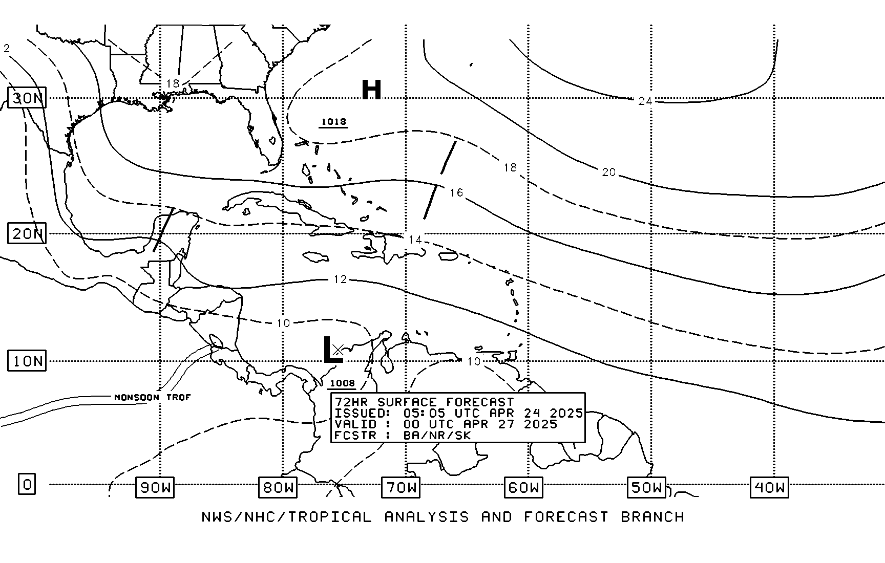
Seems like the stationary front is moving out the way according to the NHC 72hr 

0 likes
-
capNstorms
- Tropical Low

- Posts: 44
- Joined: Mon Jun 14, 2021 12:48 pm
Re: Possible Development in the GOMEX by the middle of next week
Not buying the weak storm models, this one might be concerning for TX and LA... rapid intensification, Maria, Harvey. Not writing this one off due to models going bipolar 
1 likes
- jasons2k
- Storm2k Executive

- Posts: 8083
- Age: 50
- Joined: Wed Jul 06, 2005 12:32 pm
- Location: The Woodlands, TX
Re: Possible Development in the GOMEX by the middle of next week
capNstorms wrote:Not buying the weak storm models, this one might be concerning for TX and LA... rapid intensification, Maria, Harvey. Not writing this one off due to models going bipolar
The limiting factor will be dry air. But still needs watching.
0 likes
Re: Possible Development in the GOMEX by the middle of next week
Rgv20 wrote:18zECMWF Control Run has the TC blob heading to the lower texas coast by tuesday evening. Hopefully we get some decent rains as the summer has been brutal for deep south texas.
https://i.imgur.com/I7DCpQj.png
https://i.imgur.com/wJPNBai.png
Looks like a Tropical storm hitting SEFL too.
0 likes
-
capNstorms
- Tropical Low

- Posts: 44
- Joined: Mon Jun 14, 2021 12:48 pm
Re: Possible Development in the GOMEX by the middle of next week
jasons2k wrote:capNstorms wrote:Not buying the weak storm models, this one might be concerning for TX and LA... rapid intensification, Maria, Harvey. Not writing this one off due to models going bipolar
The limiting factor will be dry air. But still needs watching.
GOM isn't dry. Right now there is dry air over land, but that will get pushed out the way

0 likes
Re: Possible Development in the GOMEX by the middle of next week
jasons2k wrote:capNstorms wrote:Not buying the weak storm models, this one might be concerning for TX and LA... rapid intensification, Maria, Harvey. Not writing this one off due to models going bipolar
The limiting factor will be dry air. But still needs watching.
Hell ya dry
0 likes
Harvey,Hanna,Beta,Texas Winter storm2021,Nicholas
Re: Possible Development in the GOMEX by the middle of next week
Realistically, a moderate wave to a low end TS is where this forms. 1 or 2 inches of rain, not enough to break a near 7 week rainless spell and 4 weeks over 100F spell.
I want to be wrong. But even the 18Z Euro and ensembles, while not giving up, are backing away from the more aggressive solutions https://www.tropicaltidbits.com/analysis/models/?model=eps®ion=watl&pkg=apcpn&runtime=2023081718&fh=144
I want to be wrong. But even the 18Z Euro and ensembles, while not giving up, are backing away from the more aggressive solutions https://www.tropicaltidbits.com/analysis/models/?model=eps®ion=watl&pkg=apcpn&runtime=2023081718&fh=144
0 likes
Re: Possible Development in the GOMEX by the middle of next week
TomballEd wrote:Realistically, a moderate wave to a low end TS is where this forms. 1 or 2 inches of rain, not enough to break a near 7 week rainless spell and 4 weeks over 100F spell.
I want to be wrong. But even the 18Z Euro and ensembles, while not giving up, are backing away from the more aggressive solutions https://www.tropicaltidbits.com/analysis/models/?model=eps®ion=watl&pkg=apcpn&runtime=2023081718&fh=144
The 18z Euro and its ensembles actually came in a bit more bullish than prior runs.
0 likes
-
Stratton23
- Category 2

- Posts: 578
- Joined: Fri Jul 21, 2023 10:59 pm
- Location: College Station, Tx
Re: Possible Development in the GOMEX by the middle of next week
Call me crazy, but I have just a get feeling this wave is going to surprise us, Ive seen this story before, the gulf can be very very tricky sometimes, maybe it throws a curveball with this one
3 likes
Who is online
Users browsing this forum: Google Adsense [Bot], JaviT and 39 guests


