Low Pressure in the Northwest Caribbean Sea (Is Invest 93L)
Moderator: S2k Moderators
Forum rules

The posts in this forum are NOT official forecasts and should not be used as such. They are just the opinion of the poster and may or may not be backed by sound meteorological data. They are NOT endorsed by any professional institution or STORM2K. For official information, please refer to products from the National Hurricane Center and National Weather Service.
-
SFLcane

- S2K Supporter

- Posts: 9620
- Age: 46
- Joined: Sat Jun 05, 2010 1:44 pm
- Location: Lake Worth Florida
Re: Possible Development in the Northwestern Caribbean
HafsB has a strong TS almost Cat 1 into Ft Myers area.
0 likes

Re: Possible Development in the Northwestern Caribbean
18Z GFS has pretty much knocked out the ULL in the east GoM on Tuesday
Last edited by GCANE on Thu Aug 24, 2023 7:40 pm, edited 1 time in total.
0 likes

Re: Possible Development in the Northwestern Caribbean
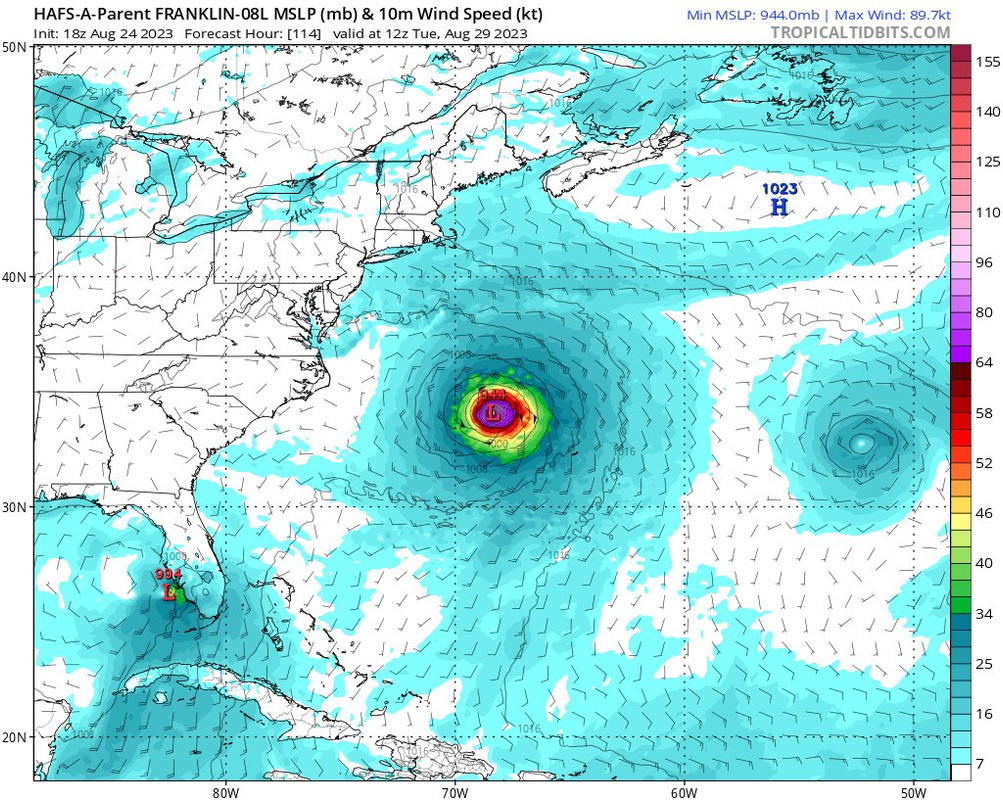
SFLcane wrote:HafsB has a strong TS almost Cat 1 into Ft Myers area.
https://i.postimg.cc/jj64HDR6/IMG-7500.jpg
Seems reasonable. Will catch a lot off guard since it's the weekend. However we need the rain. Any sustained min hurricane winds would be along the coast, inland some gusts to 80. Damage wise wouldn't be much but for the beach communities would suck for Ian recovery. based on that image probably a 65mph storm. Looks pretty disorganized and only 994mb. Doesn't get really organized until right before landfall and still looks sheared.
0 likes
Re: Possible Development in the Northwestern Caribbean: 8 PM TWO=Code Red
wxman57 wrote:IcyTundra wrote:Probably not going to happen but I hope that it stalls long enough to miss the trough and we can get some of that moisture to come to Texas. Central Texas coast to the Upper Texas coast is in a extreme drought right now.
Not much chance of it coming our way.
What's your current predictions of landfall location and intensity?
I recall Ian you pegged Ft. Myers pretty far out, but I remember you had the intensity a bit too low though.
0 likes
-
gatorcane

- S2K Supporter
- Posts: 23499
- Age: 46
- Joined: Sun Mar 13, 2005 3:54 pm
- Location: Boca Raton, FL
Re: Possible Development in the Northwestern Caribbean
Looks like the 18Z Euro is a slightly weaker again at the 72 hour mark compared to the 12Z plus it is more over the Yucatán on the 18Z which is why it is probably a bit weaker. Seems the trend with the Euro is weaker each run.
Surprised NHC went up to 70%, would have kept it at 60% until we see at least something on the GFS.
Surprised NHC went up to 70%, would have kept it at 60% until we see at least something on the GFS.
1 likes
-
jlauderdal
- S2K Supporter
- Posts: 6779
- Joined: Wed May 19, 2004 5:46 am
- Location: NE Fort Lauderdale
- Contact:
Re: RE: Re: Possible Development in the Northwestern Caribbean: 8 PM TWO=Code Red
At least a major into tampa or new orleansSFLcane wrote:Now can we just get some hwrf going!

0 likes

Re: Possible Development in the Northwestern Caribbean
gatorcane wrote:Looks like the 18Z Euro is a slightly weaker again at the 72 hour mark compared to the 12Z plus it is more over the Yucatán on the 18Z which is why it is probably a bit weaker. Seems the trend with the Euro is weaker each run.
Surprised NHC went up to 70%, would have kept it at 60% until we see at least something on the GFS.
Might be waiting a while for that one
0 likes
-
jlauderdal
- S2K Supporter
- Posts: 6779
- Joined: Wed May 19, 2004 5:46 am
- Location: NE Fort Lauderdale
- Contact:
Re: RE: Re: Possible Development in the Northwestern Caribbean: 8 PM TWO=Code Red
The gfs struggles in many ways, lets see how fast to catch up?Hypercane_Kyle wrote:Surprised the GFS is struggling so much with this one, normally it's the Euro struggling with these setups and GFS predicting genesis.
0 likes

Re: Possible Development in the Northwestern Caribbean
GCANE wrote:Will be interesting to see how this model pans out.
AI based Pangu
Latest run has Tampa Bay taking the hit.
https://charts.ecmwf.int/products/pangu ... 2308300000
Which usually means it’s not coming to tampa bay lol
0 likes
Robbielyn McCrary
I know just about enough to sound like I know what I'm talking about sometimes. But for your safety please follow the nhc for truly professional forecasting.
I know just about enough to sound like I know what I'm talking about sometimes. But for your safety please follow the nhc for truly professional forecasting.

Re: Possible Development in the Northwestern Caribbean: 8 PM TWO=Code Red
wxman57 wrote:IcyTundra wrote:Probably not going to happen but I hope that it stalls long enough to miss the trough and we can get some of that moisture to come to Texas. Central Texas coast to the Upper Texas coast is in a extreme drought right now.
Not much chance of it coming our way.
That's what I thought just trying to wishcast lol.
0 likes
-
CrazyC83
- Professional-Met

- Posts: 33397
- Joined: Tue Mar 07, 2006 11:57 pm
- Location: Deep South, for the first time!
Re: Possible Development in the Northwestern Caribbean
The fact that water temperatures in the low 90s lie ahead is probably why they went so high. That is rocket fuel if it can take advantage of it, but without a spark or with bad ingredients such as wind shear or dry air, nothing happens.
2 likes
-
SunnyThoughts
- Category 5

- Posts: 2263
- Joined: Wed Jul 09, 2003 12:42 pm
- Location: Pensacola, Florida
Re: Possible Development in the Northwestern Caribbean: 8 PM TWO=Code Red
IcyTundra wrote:wxman57 wrote:IcyTundra wrote:Probably not going to happen but I hope that it stalls long enough to miss the trough and we can get some of that moisture to come to Texas. Central Texas coast to the Upper Texas coast is in a extreme drought right now.
Not much chance of it coming our way.
That's what I thought just trying to wishcast lol.
I think we are all doing a little wishcasting right now. Heat is unbearable for so many.
2 likes
-
jlauderdal
- S2K Supporter
- Posts: 6779
- Joined: Wed May 19, 2004 5:46 am
- Location: NE Fort Lauderdale
- Contact:
Re: RE: Re: Possible Development in the Northwestern Caribbean: 8 PM TWO=Code Red
No need for it in SEFLA, we have had a very active rainy season...already past the season average at FLLSunnyThoughts wrote:IcyTundra wrote:wxman57 wrote:
Not much chance of it coming our way.
That's what I thought just trying to wishcast lol.
I think we are all doing a little wishcasting right now. Heat is unbearable for so many.
0 likes
-
SouthFLTropics

- Category 5
- Posts: 4156
- Age: 48
- Joined: Thu Aug 14, 2003 8:04 am
- Location: Port St. Lucie, Florida
Re: Possible Development in the Northwestern Caribbean
Just for reference, the next name on the list for 2023 is the dreaded "I" name. Hopefully this will not live up to its predecessors. The next name is Idalia, pronounced ee-DAL-ya.
2 likes
Fourth Generation Floridian...With lots of storm knowledge passed down from my elders...
Personal Storm History: David 79, Andrew 92, Erin 95, Floyd 99, Irene 99, Frances 04, Jeanne 04, Wilma 05, Matthew 16, Irma 17
Personal Storm History: David 79, Andrew 92, Erin 95, Floyd 99, Irene 99, Frances 04, Jeanne 04, Wilma 05, Matthew 16, Irma 17
-
gatorcane
- S2K Supporter
- Posts: 23499
- Age: 46
- Joined: Sun Mar 13, 2005 3:54 pm
- Location: Boca Raton, FL
Re: Possible Development in the Northwestern Caribbean
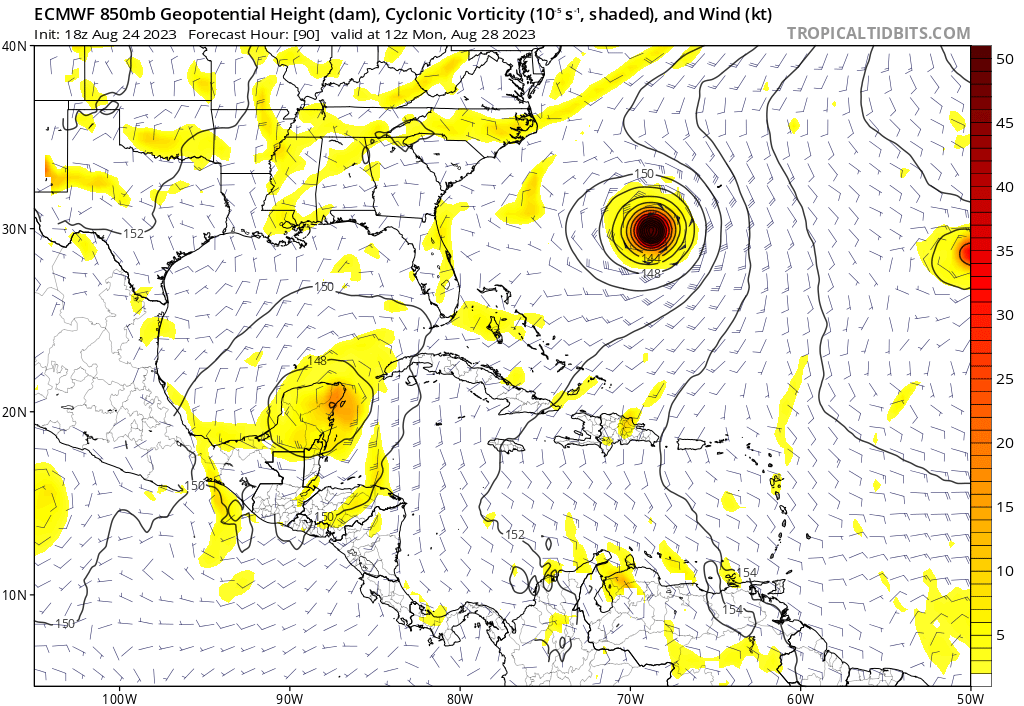
Notably weaker on the 18Z Euro compared to the 12Z:
0 likes
Re: Possible Development in the Northwestern Caribbean
gatorcane wrote:Notably weaker on the 18Z Euro compared to the 12Z:
https://i.postimg.cc/HsKzYjjt/ecmwf-z850-vort-watl-31.png
https://i.postimg.cc/Fz6yHnFK/ecmwf-z850-vort-watl-33.png
That's because it's moving a tad slower on the 18z so that's why it's 2mb higher due to prolong land interaction.
0 likes
Re: Possible Development in the Northwestern Caribbean
18z euro ensembles not much change from 12z. More concentrated towards FL though this run.
https://weather.us/cyclone-tracks/euro/ ... 8-144.html
https://weather.us/cyclone-tracks/euro/ ... 8-144.html
0 likes
-
Kingarabian

- S2K Supporter
- Posts: 15454
- Joined: Sat Aug 08, 2009 3:06 am
- Location: Honolulu, Hawaii
Re: Possible Development in the Northwestern Caribbean
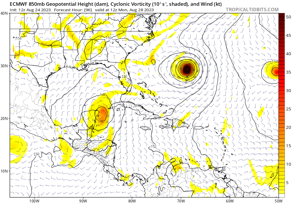
gatorcane wrote:Notably weaker on the 18Z Euro compared to the 12Z:
https://i.postimg.cc/HsKzYjjt/ecmwf-z850-vort-watl-31.png
https://i.postimg.cc/Fz6yHnFK/ecmwf-z850-vort-watl-33.png
But could be stronger beyond 72hrs if it went that far out. It's more NW on this run which will mean more time over water.
0 likes
RIP Kobe Bryant
-
OuterBanker
- S2K Supporter
- Posts: 1704
- Joined: Wed Feb 26, 2003 10:53 am
- Location: Nags Head, NC
- Contact:
Re: Possible Development in the Northwestern Caribbean
No HWRF until we get an invest. 12z Euro does have a cat one around Hatteras on Thursday.
0 likes
-
SFLcane
- S2K Supporter
- Posts: 9620
- Age: 46
- Joined: Sat Jun 05, 2010 1:44 pm
- Location: Lake Worth Florida
Re: RE: Re: Possible Development in the Northwestern Caribbean: 8 PM TWO=Code Red
jlauderdal wrote:No need for it in SEFLA, we have had a very active rainy season...already past the season average at FLLSunnyThoughts wrote:IcyTundra wrote:
That's what I thought just trying to wishcast lol.
I think we are all doing a little wishcasting right now. Heat is unbearable for so many.
Lol wait till November January when El Niños influence gets stronger. Cfs has a boat load of rain right through the holidays into next year. We’re gonna need a bigger boat!
0 likes
Who is online
Users browsing this forum: hurricanes1234, Killjoy12, lilbump3000, Tak5, Teban54, TheWisestofAll and 56 guests