Kingarabian wrote::uarrow: 2018-2019 the atmosphere was in El Nino.
It was a weak El Nino, this one is the strongest since 2015.
Moderator: S2k Moderators


Kingarabian wrote::uarrow: 2018-2019 the atmosphere was in El Nino.


Iceresistance wrote:Kingarabian wrote::uarrow: 2018-2019 the atmosphere was in El Nino.
It was a weak El Nino, this one is the strongest since 2015.


Iceresistance wrote:Kingarabian wrote::uarrow: 2018-2019 the atmosphere was in El Nino.
It was a weak El Nino, this one is the strongest since 2015.
cycloneye wrote:Iceresistance wrote:Kingarabian wrote::uarrow: 2018-2019 the atmosphere was in El Nino.
It was a weak El Nino, this one is the strongest since 2015.
We will know tommorow if the present El Niño will be upgraded to moderate. 9 AM EDT is the time CPC releases it.
Ntxw wrote:cycloneye wrote:Iceresistance wrote:It was a weak El Nino, this one is the strongest since 2015.
We will know tommorow if the present El Niño will be upgraded to moderate. 9 AM EDT is the time CPC releases it.
Think that's the most likely scenario. MEI and RONI are more indicative of weak though, but the SOI is telling us August has changed and JA MEI might go above, JJ saw enough of a rise despite not making much progress on the weekly front.

LarryWx wrote:Ntxw wrote:cycloneye wrote:
We will know tommorow if the present El Niño will be upgraded to moderate. 9 AM EDT is the time CPC releases it.
Think that's the most likely scenario. MEI and RONI are more indicative of weak though, but the SOI is telling us August has changed and JA MEI might go above, JJ saw enough of a rise despite not making much progress on the weekly front.
The recent -SOI dominant period has been driven by very high Darwin SLP rather than low Tahiti SLP. As a matter of fact, the three week period ending this Friday August 11th is going to end up having the highest three week averaged Darwin SLP on record by a good margin (records go back to 1991-2 El Niño). Here are the top five highest 21 day averaged Darwin SLPs on record:
1) 7/22-8/11/2023: ~1016.00 mb (exact # TBD on Friday)
2) 7/26-8/15/1997: 1015.83 mb
3) 8/4-8/24/1993: 1015.73 mb (not El Niño)
4) 7/11-31/2015: 1015.65 mb
5) 8/2-8/22/1994: 1015.54 mb
Emmett_Brown wrote:LarryWx wrote:Ntxw wrote:
Think that's the most likely scenario. MEI and RONI are more indicative of weak though, but the SOI is telling us August has changed and JA MEI might go above, JJ saw enough of a rise despite not making much progress on the weekly front.
The recent -SOI dominant period has been driven by very high Darwin SLP rather than low Tahiti SLP. As a matter of fact, the three week period ending this Friday August 11th is going to end up having the highest three week averaged Darwin SLP on record by a good margin (records go back to 1991-2 El Niño). Here are the top five highest 21 day averaged Darwin SLPs on record:
1) 7/22-8/11/2023: ~1016.00 mb (exact # TBD on Friday)
2) 7/26-8/15/1997: 1015.83 mb
3) 8/4-8/24/1993: 1015.73 mb (not El Niño)
4) 7/11-31/2015: 1015.65 mb
5) 8/2-8/22/1994: 1015.54 mb
I asked Bard AI which is more important; high Darwin pressure or low Tahiti pressure, and here is what it said:
"The most important factor when evaluating a negative SOI related to El Niño is how low the pressure is at Tahiti. This is because the Southern Oscillation Index (SOI) is calculated by taking the difference in air pressure between Tahiti and Darwin. A negative SOI means that the pressure is lower at Tahiti than it is at Darwin. This difference in pressure is caused by the changes in ocean temperatures that occur during El Niño events.
When the ocean temperatures in the eastern tropical Pacific Ocean warm up, the trade winds weaken. This allows warm water to pool in the eastern Pacific Ocean, which further warms the ocean and weakens the trade winds. The weakening of the trade winds also causes the air pressure to drop at Tahiti.
The combination of warm ocean temperatures and low air pressure at Tahiti is what defines a negative SOI and an El Niño event. Therefore, the lower the pressure is at Tahiti, the more likely it is that an El Niño event is occurring.
The high pressure at Darwin is not as important of a factor in determining whether or not an El Niño event is occurring. This is because the high pressure at Darwin is caused by the warm water that is pooling in the eastern Pacific Ocean. The warm water is also responsible for the low pressure at Tahiti.
In conclusion, the most important factor when evaluating a negative SOI related to El Niño is how low the pressure is at Tahiti. The high pressure at Darwin is not as important of a factor."
cycloneye wrote:Iceresistance wrote:Kingarabian wrote::uarrow: 2018-2019 the atmosphere was in El Nino.
It was a weak El Nino, this one is the strongest since 2015.
We will know tommorow if the present El Niño will be upgraded to moderate. 9 AM EDT is the time CPC releases it.
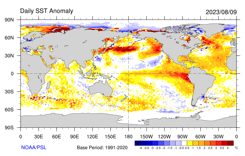
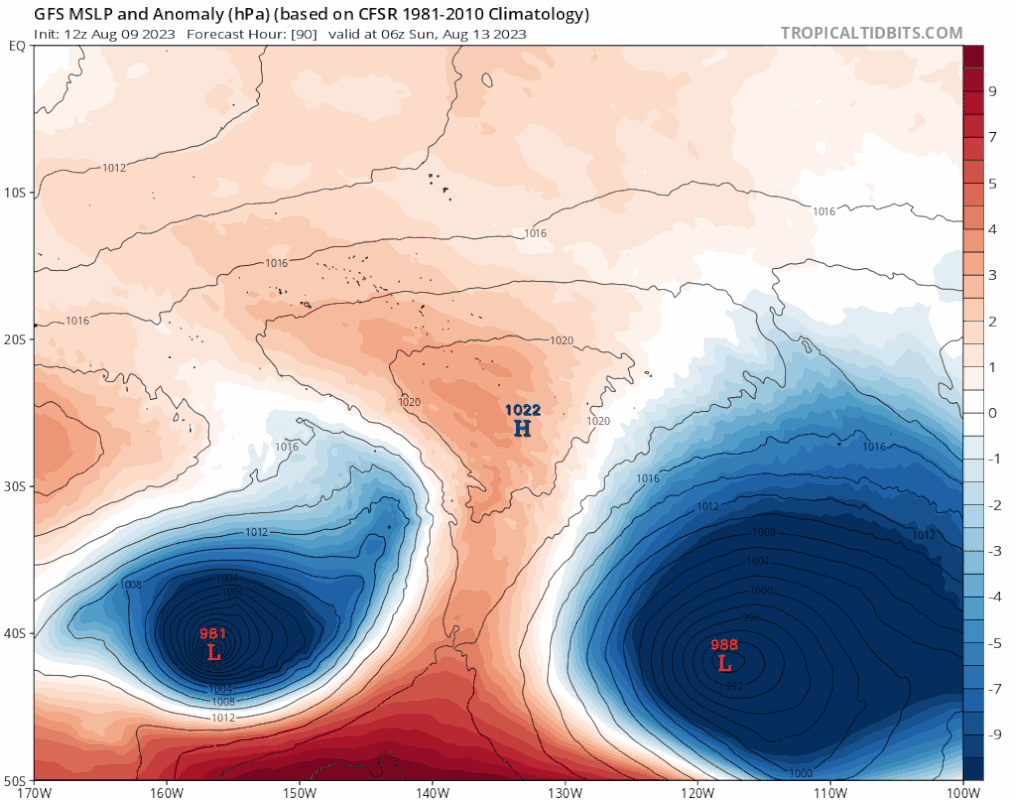
Kingarabian wrote:The warm/positive horseshoe is clearly trying to setup in the NE Pacific. But the WNW/NW Pacific is also warming and will negate the NE Pacific's contribution to the PDO. Also making things really difficult is the -PMM which seems to be getting stronger.
https://i.postimg.cc/13Zjjw1H/sst-daily-anom.gif


cycloneye wrote:Kingarabian wrote:The warm/positive horseshoe is clearly trying to setup in the NE Pacific. But the WNW/NW Pacific is also warming and will negate the NE Pacific's contribution to the PDO. Also making things really difficult is the -PMM which seems to be getting stronger.
https://i.postimg.cc/13Zjjw1H/sst-daily-anom.gif
In summary, what all this means for the big picture of El Niño getting stronger or not?

weeniepatrol wrote:Also, (and apologies if this was already posted) ONI for MJJ was +0.8. JJA should be very close to +1.0.
Every successive trimonthly has risen by +0.3 since DJF. On track for moderate or strong peak.
https://i.imgur.com/sqaxHpI.png
Ntxw wrote:I think the CFSv2 has done a OK job with the subsurface. It's weakened a lot but has steadied out. Going forward, if you follow that model, a rebound will occur in Sept and Oct as the thermocline levels out alongside changing climo. New downwelling of warm water is occurring out west that will show up later in the east. As far as the winds go, the eastern Pacific yet again is seeing westerly anomalies (aided more by EPAC cyclone activity) for this tilted Nino.
SOI has risen positive after the long stretch of negatives for the time being.
Users browsing this forum: kevin and 26 guests

