2024 Indicators: SST's, MSLP, Shear, SAL, Steering, Instability (Day 16+ Climate Models)

This is the general tropical discussion area. Anyone can take their shot at predicting a storms path.

Moderator: S2k Moderators

Forum rules

The posts in this forum are NOT official forecasts and should not be used as such. They are just the opinion of the poster and may or may not be backed by sound meteorological data. They are NOT endorsed by any professional institution or STORM2K. For official information, please refer to products from the National Hurricane Center and National Weather Service.

Help Support Storm2K
Message
Author
User avatar
skyline385
Category 5
Category 5
Posts: 2503
Age: 33
Joined: Wed Aug 26, 2020 11:15 pm
Location: Houston TX

Re: 2024 Indicators: SST's, MSLP, Shear, SAL, Steering, Instability (Day 16+ Climate Models) C3S may run is posted

#861 Postby skyline385 » Fri May 10, 2024 9:28 am

cycloneye wrote:The C3S model may run has the same look as other climate models.


I imagine it's because C3S is just an ensemble model consisting of all the climate models and all climate models this month have had very similar solutions.
1 likes   

Stratton23
Category 2
Category 2
Posts: 578
Joined: Fri Jul 21, 2023 10:59 pm
Location: College Station, Tx

Re: 2024 Indicators: SST's, MSLP, Shear, SAL, Steering, Instability (Day 16+ Climate Models) C3S may run is posted

#862 Postby Stratton23 » Fri May 10, 2024 3:25 pm

Man the gulf is really start to warm up fast
0 likes   

User avatar
cycloneye
Admin
Admin
Posts: 139334
Age: 67
Joined: Thu Oct 10, 2002 10:54 am
Location: San Juan, Puerto Rico

Re: 2024 Indicators: SST's, MSLP, Shear, SAL, Steering, Instability (Day 16+ Climate Models) C3S may run is posted

#863 Postby cycloneye » Fri May 10, 2024 3:45 pm

0 likes   
Visit the Caribbean-Central America Weather Thread where you can find at first post web cams,radars
and observations from Caribbean basin members Click Here

User avatar
cycloneye
Admin
Admin
Posts: 139334
Age: 67
Joined: Thu Oct 10, 2002 10:54 am
Location: San Juan, Puerto Rico

Re: 2024 Indicators: SST's, MSLP, Shear, SAL, Steering, Instability (Day 16+ Climate Models) C3S may run is posted

#864 Postby cycloneye » Fri May 10, 2024 4:04 pm

0 likes   
Visit the Caribbean-Central America Weather Thread where you can find at first post web cams,radars
and observations from Caribbean basin members Click Here

User avatar
StPeteMike
Category 1
Category 1
Posts: 375
Joined: Thu Jun 07, 2018 11:26 pm

Re: 2024 Indicators: SST's, MSLP, Shear, SAL, Steering, Instability (Day 16+ Climate Models) C3S may run is posted

#865 Postby StPeteMike » Fri May 10, 2024 4:15 pm

:
cycloneye wrote:The plot keeps thickening.

https://twitter.com/BenNollWeather/status/1789033295722016854

:double:
0 likes   
The above post is not official and should not be used as such. It is the opinion of the poster and may or may not be backed by sound meteorological data. It is not endorsed by any professional institution or storm2k.org. For official information, please refer to the NHC and NWS products.

User avatar
Category5Kaiju
Category 5
Category 5
Posts: 3404
Age: 22
Joined: Thu Dec 24, 2020 12:45 pm
Location: Seattle

Re: 2024 Indicators: SST's, MSLP, Shear, SAL, Steering, Instability (Day 16+ Climate Models) C3S may run is posted

#866 Postby Category5Kaiju » Fri May 10, 2024 5:45 pm

cycloneye wrote:The plot keeps thickening.

https://twitter.com/BenNollWeather/status/1789033295722016854


Wow. Just wow.

I don't really even see a signature for fish storms. Literally the bulk of the wet anomalies are blanketing everywhere in the western part of the basin where people live. Sheesh, this season really has the potential to be a memorable one I'm afraid.
4 likes   
Unless explicitly stated, all information covered in my posts is based on my opinions and observations. Please refer to a professional meteorologist or an accredited weather research agency otherwise, especially if serious decisions must be made in the event of a potentially life-threatening tropical storm or hurricane.

User avatar
cycloneye
Admin
Admin
Posts: 139334
Age: 67
Joined: Thu Oct 10, 2002 10:54 am
Location: San Juan, Puerto Rico

Re: 2024 Indicators: SST's, MSLP, Shear, SAL, Steering, Instability (Day 16+ Climate Models) C3S may run is posted

#867 Postby cycloneye » Fri May 10, 2024 7:11 pm

0 likes   
Visit the Caribbean-Central America Weather Thread where you can find at first post web cams,radars
and observations from Caribbean basin members Click Here

Stratton23
Category 2
Category 2
Posts: 578
Joined: Fri Jul 21, 2023 10:59 pm
Location: College Station, Tx

Re: 2024 Indicators: SST's, MSLP, Shear, SAL, Steering, Instability (Day 16+ Climate Models) C3S may run is posted

#868 Postby Stratton23 » Fri May 10, 2024 7:30 pm

Cycloneeye looks like the heat ridge may be centered more over the desert SW if im reading that correctly, that could lead to big trouble in the gulf during the season
1 likes   

User avatar
chaser1
S2K Supporter
S2K Supporter
Posts: 4716
Age: 63
Joined: Sat Oct 15, 2005 5:59 pm
Location: Longwood, Fl

Re: 2024 Indicators: SST's, MSLP, Shear, SAL, Steering, Instability (Day 16+ Climate Models)

#869 Postby chaser1 » Sat May 11, 2024 1:52 am

Here's a curious thought. I recall that over most of the past years there seemed to be some kind of inverse correlation between the Spring Tornado season, and the Summer/Fall Hurricane season. It seemed that following a very active tornado season, that upcoming Atlantic Hurricane season would tend to be less busy. Conversely, following a underactive Spring Tornado season, those Atlantic Hurricane seasons seemed to produce above average numbers. I do not know if there is adequate science to back that up or simply an incorrect perception. I bring this up simply because this present Tornado season seems quite active, yet so are everyone's projections for the upcoming Hurricane season as well.
0 likes   
Personal Forecast Disclaimer:
The posts in this forum are NOT official forecast and should not be used as such. They are just the opinion of the poster and may or may not be backed by sound meteorological data. They are NOT endorsed by any professional institution or storm2k.org. For official information, please refer to the NHC and NWS products.


User avatar
skyline385
Category 5
Category 5
Posts: 2503
Age: 33
Joined: Wed Aug 26, 2020 11:15 pm
Location: Houston TX

Re: 2024 Indicators: SST's, MSLP, Shear, SAL, Steering, Instability (Day 16+ Climate Models)

#870 Postby skyline385 » Sat May 11, 2024 2:10 am

chaser1 wrote:Here's a curious thought. I recall that over most of the past years there seemed to be some kind of inverse correlation between the Spring Tornado season, and the Summer/Fall Hurricane season. It seemed that following a very active tornado season, that upcoming Atlantic Hurricane season would tend to be less busy. Conversely, following a underactive Spring Tornado season, those Atlantic Hurricane seasons seemed to produce above average numbers. I do not know if there is adequate science to back that up or simply an incorrect perception. I bring this up simply because this present Tornado season seems quite active, yet so are everyone's projections for the upcoming Hurricane season as well.


Well, the most active tornado seasons (per a quick google) are:

2011: 1,894 tornadoes
2004: 1,820 tornadoes
2008: 1,685 tornadoes
2010: 1,543 tornadoes
2017: 1,522 tornadoes
1998: 1,440 tornadoes
2003: 1,374 tornadoes
1999: 1,364 tornadoes
1992: 1,312 tornadoes
2009: 1,305 tornadoes

Out of this, only 1992 and 2009 were below average. All of the others were above-average to hyperactive including big names like 2004, 2010 and 2017. So to me it looks like there is a direct relationship (if one exists) between hurricane season activity and tornado season.
4 likes   

User avatar
Category5Kaiju
Category 5
Category 5
Posts: 3404
Age: 22
Joined: Thu Dec 24, 2020 12:45 pm
Location: Seattle

Re: 2024 Indicators: SST's, MSLP, Shear, SAL, Steering, Instability (Day 16+ Climate Models)

#871 Postby Category5Kaiju » Sat May 11, 2024 8:42 am

The way I understood it, tornado seasons are usually associated with warm Gulf of Mexico temperatures rather than Atlantic activity as a whole (because if that were the case then you probably wouldn't expect to see years like 1998, 2004, 2010, or 2017 up there).

It's also quite interesting to see that many of those high-tornado-frequency years are associated with seasons with powerful west-tracking Cape Verde storms (Georges, Isabel, Ivan, Ike, Irma to name a few). The big names that, you know, are frequently referenced by wx people.
4 likes   
Unless explicitly stated, all information covered in my posts is based on my opinions and observations. Please refer to a professional meteorologist or an accredited weather research agency otherwise, especially if serious decisions must be made in the event of a potentially life-threatening tropical storm or hurricane.

User avatar
TheAustinMan
Category 5
Category 5
Posts: 1010
Age: 24
Joined: Mon Jul 08, 2013 4:26 pm
Location: United States
Contact:

Re: 2024 Indicators: SST's, MSLP, Shear, SAL, Steering, Instability (Day 16+ Climate Models)

#872 Postby TheAustinMan » Sat May 11, 2024 11:40 am

chaser1 wrote:Here's a curious thought. I recall that over most of the past years there seemed to be some kind of inverse correlation between the Spring Tornado season, and the Summer/Fall Hurricane season. It seemed that following a very active tornado season, that upcoming Atlantic Hurricane season would tend to be less busy. Conversely, following a underactive Spring Tornado season, those Atlantic Hurricane seasons seemed to produce above average numbers. I do not know if there is adequate science to back that up or simply an incorrect perception. I bring this up simply because this present Tornado season seems quite active, yet so are everyone's projections for the upcoming Hurricane season as well.


There might be a physical relationship between the kinds of upper-level patterns that affect storm tracks over the continental US in spring and the spring/summer patterns that affect the oceanic state for hurricanes, but I'm not convinced much insight can be gained from just the count of tornadoes. If we consider significant tornadoes (EF2+ or F2+), there is hardly a clear relationship between the number of those tornadoes in March/April/May and the Atlantic accumulated cyclone energy.

Source: Made in Excel. Tornado counts from Tornado Archive
Image
6 likes   
ImageImageImage
Treat my opinions with a grain of salt. For official information see your local weather service.

User avatar
skyline385
Category 5
Category 5
Posts: 2503
Age: 33
Joined: Wed Aug 26, 2020 11:15 pm
Location: Houston TX

Re: 2024 Indicators: SST's, MSLP, Shear, SAL, Steering, Instability (Day 16+ Climate Models)

#873 Postby skyline385 » Sat May 11, 2024 12:07 pm

Category5Kaiju wrote:The way I understood it, tornado seasons are usually associated with warm Gulf of Mexico temperatures rather than Atlantic activity as a whole (because if that were the case then you probably wouldn't expect to see years like 1998, 2004, 2010, or 2017 up there).


GoM temperatures should partially influence tornado seasons since most large outbreaks require a healthy advection of Gulf moisture to the plains for supercells to start blowing up everywhere. A warmer Gulf would mean more moisture in the air and hence higher dewpoints being moved to the plains.
0 likes   

USTropics
Category 5
Category 5
Posts: 2420
Joined: Sun Aug 12, 2007 3:45 am
Location: Florida State University

Re: 2024 Indicators: SST's, MSLP, Shear, SAL, Steering, Instability (Day 16+ Climate Models)

#874 Postby USTropics » Sat May 11, 2024 12:28 pm

TheAustinMan wrote:
chaser1 wrote:Here's a curious thought. I recall that over most of the past years there seemed to be some kind of inverse correlation between the Spring Tornado season, and the Summer/Fall Hurricane season. It seemed that following a very active tornado season, that upcoming Atlantic Hurricane season would tend to be less busy. Conversely, following a underactive Spring Tornado season, those Atlantic Hurricane seasons seemed to produce above average numbers. I do not know if there is adequate science to back that up or simply an incorrect perception. I bring this up simply because this present Tornado season seems quite active, yet so are everyone's projections for the upcoming Hurricane season as well.


There might be a physical relationship between the kinds of upper-level patterns that affect storm tracks over the continental US in spring and the spring/summer patterns that affect the oceanic state for hurricanes, but I'm not convinced much insight can be gained from just the count of tornadoes. If we consider significant tornadoes (EF2+ or F2+), there is hardly a clear relationship between the number of those tornadoes in March/April/May and the Atlantic accumulated cyclone energy.

Source: Made in Excel. Tornado counts from Tornado Archive
https://i.imgur.com/soHbPs4.png


As always, excellent work on displaying the data. i would agree there isn't a connection between hurricanes and the quantity of tornadoes. The timescales are significantly different; supercells and MCCs have timescales of hours to ~1 day, hurricanes (especially from AEWs) are more multiweek timescales. I'm curious how the data looks like for transitioning ENSO states (particularly strong El Nino to La Nina by summer transitions). If I recall, 1982-83 and 1997-98 had significant tornadoes and closely resemble our current ENSO transition. I would plot the data, but only have mobile data and a tablet (did some 'tornado chasing' yesterday morning, aka walked out my apartment door here in Tallahassee). Currently there is still ~60-70K of us without power.
3 likes   

User avatar
chaser1
S2K Supporter
S2K Supporter
Posts: 4716
Age: 63
Joined: Sat Oct 15, 2005 5:59 pm
Location: Longwood, Fl

Re: 2024 Indicators: SST's, MSLP, Shear, SAL, Steering, Instability (Day 16+ Climate Models)

#875 Postby chaser1 » Sat May 11, 2024 4:51 pm

USTropics wrote:
TheAustinMan wrote:
chaser1 wrote:Here's a curious thought. I recall that over most of the past years there seemed to be some kind of inverse correlation between the Spring Tornado season, and the Summer/Fall Hurricane season. It seemed that following a very active tornado season, that upcoming Atlantic Hurricane season would tend to be less busy. Conversely, following a underactive Spring Tornado season, those Atlantic Hurricane seasons seemed to produce above average numbers. I do not know if there is adequate science to back that up or simply an incorrect perception. I bring this up simply because this present Tornado season seems quite active, yet so are everyone's projections for the upcoming Hurricane season as well.


There might be a physical relationship between the kinds of upper-level patterns that affect storm tracks over the continental US in spring and the spring/summer patterns that affect the oceanic state for hurricanes, but I'm not convinced much insight can be gained from just the count of tornadoes. If we consider significant tornadoes (EF2+ or F2+), there is hardly a clear relationship between the number of those tornadoes in March/April/May and the Atlantic accumulated cyclone energy.

Source: Made in Excel. Tornado counts from Tornado Archive
https://i.imgur.com/soHbPs4.png


As always, excellent work on displaying the data. i would agree there isn't a connection between hurricanes and the quantity of tornadoes. The timescales are significantly different; supercells and MCCs have timescales of hours to ~1 day, hurricanes (especially from AEWs) are more multiweek timescales. I'm curious how the data looks like for transitioning ENSO states (particularly strong El Nino to La Nina by summer transitions). If I recall, 1982-83 and 1997-98 had significant tornadoes and closely resemble our current ENSO transition. I would plot the data, but only have mobile data and a tablet (did some 'tornado chasing' yesterday morning, aka walked out my apartment door here in Tallahassee). Currently there is still ~60-70K of us without power.


LOL, your Tornado chasing sounds akin to my Aurora chasing I plan on doing from the Orlando area this evening!! I'll bother to drive an hour to get away from all the ambient light, but that's it. Yeah, clearly my memory does NOT serve me right with regard to any inverse correlation between Hurricane & Tornado seasons. Thanks for the research and info - good stuff!
1 likes   
Personal Forecast Disclaimer:
The posts in this forum are NOT official forecast and should not be used as such. They are just the opinion of the poster and may or may not be backed by sound meteorological data. They are NOT endorsed by any professional institution or storm2k.org. For official information, please refer to the NHC and NWS products.


User avatar
cheezyWXguy
Category 5
Category 5
Posts: 5556
Joined: Mon Feb 13, 2006 12:29 am
Location: Dallas, TX

Re: 2024 Indicators: SST's, MSLP, Shear, SAL, Steering, Instability (Day 16+ Climate Models)

#876 Postby cheezyWXguy » Sat May 11, 2024 5:08 pm

USTropics wrote:
TheAustinMan wrote:
chaser1 wrote:Here's a curious thought. I recall that over most of the past years there seemed to be some kind of inverse correlation between the Spring Tornado season, and the Summer/Fall Hurricane season. It seemed that following a very active tornado season, that upcoming Atlantic Hurricane season would tend to be less busy. Conversely, following a underactive Spring Tornado season, those Atlantic Hurricane seasons seemed to produce above average numbers. I do not know if there is adequate science to back that up or simply an incorrect perception. I bring this up simply because this present Tornado season seems quite active, yet so are everyone's projections for the upcoming Hurricane season as well.


There might be a physical relationship between the kinds of upper-level patterns that affect storm tracks over the continental US in spring and the spring/summer patterns that affect the oceanic state for hurricanes, but I'm not convinced much insight can be gained from just the count of tornadoes. If we consider significant tornadoes (EF2+ or F2+), there is hardly a clear relationship between the number of those tornadoes in March/April/May and the Atlantic accumulated cyclone energy.

Source: Made in Excel. Tornado counts from Tornado Archive
https://i.imgur.com/soHbPs4.png


As always, excellent work on displaying the data. i would agree there isn't a connection between hurricanes and the quantity of tornadoes. The timescales are significantly different; supercells and MCCs have timescales of hours to ~1 day, hurricanes (especially from AEWs) are more multiweek timescales. I'm curious how the data looks like for transitioning ENSO states (particularly strong El Nino to La Nina by summer transitions). If I recall, 1982-83 and 1997-98 had significant tornadoes and closely resemble our current ENSO transition. I would plot the data, but only have mobile data and a tablet (did some 'tornado chasing' yesterday morning, aka walked out my apartment door here in Tallahassee). Currently there is still ~60-70K of us without power.

I also agree there isn’t a correlation between sigtors or tornado counts and ace, but I wonder if we may find a more useful correlation by looking at the respective qualities of tornado seasons and their subsequent hurricane seasons. For example, does a plains-heavy tornado season lead into a hurricane season with more landfalling storms than a Dixie alley season? What synoptic scale factors that drive tornadoes, or severe weather general, might later influence quality, quantity, and behavior of hurricanes? Would a higher frequency of negatively tilted conus troughs in spring carry over into more landfalls/recurvatures during hurricane season, or have some impact on late season Caribbean activity?

Just kind of spitballing questions here, and haven’t really looked into it before, so maybe some of yall already have answers for these
5 likes   

User avatar
chaser1
S2K Supporter
S2K Supporter
Posts: 4716
Age: 63
Joined: Sat Oct 15, 2005 5:59 pm
Location: Longwood, Fl

Re: 2024 Indicators: SST's, MSLP, Shear, SAL, Steering, Instability (Day 16+ Climate Models)

#877 Postby chaser1 » Sat May 11, 2024 6:09 pm

I think it's a legit rabbit hole to pursue. If one thinks about it, a pattern of positive tilt or negative tilt short waves or simply the long wave pattern itself would seem to tip off potential upcoming tropical Cyclone tracks. Granted, patterns change but even a few bread crumbs might suggest a little bit of evidence to suggest where some storm tracks may occur.
2 likes   
Personal Forecast Disclaimer:
The posts in this forum are NOT official forecast and should not be used as such. They are just the opinion of the poster and may or may not be backed by sound meteorological data. They are NOT endorsed by any professional institution or storm2k.org. For official information, please refer to the NHC and NWS products.


User avatar
DorkyMcDorkface
Category 2
Category 2
Posts: 721
Age: 26
Joined: Mon Sep 30, 2019 1:32 pm
Location: Mid-Atlantic

Re: 2024 Indicators: SST's, MSLP, Shear, SAL, Steering, Instability (Day 16+ Climate Models)

#878 Postby DorkyMcDorkface » Sat May 11, 2024 9:14 pm

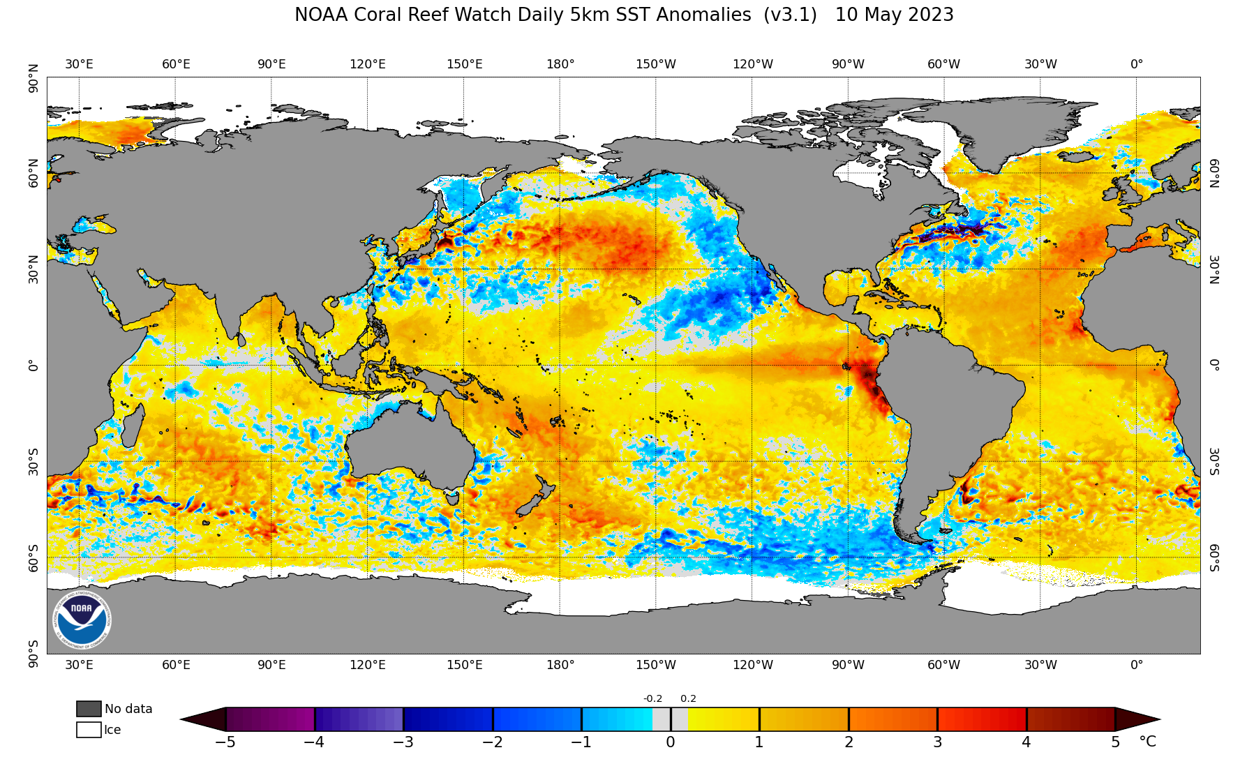
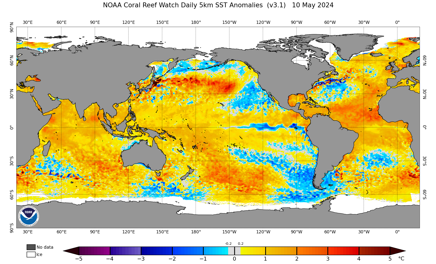
Interesting to see the Atlantic Niño (and much of the South Atlantic north of 20S in general) cool off quite a bit as of late. Wondering if this could be heralding a more +AMM configuration once again. Remember last month much of the seasonal guidance adjusted to show a prominent Atlantic Niño/warmer SATL but for this month they've backed off on that idea slightly.
Image
Image
4 likes   
Floyd 1999 | Isabel 2003 | Hanna 2008 | Irene 2011 | Sandy 2012 | Isaias 2020

User avatar
Category5Kaiju
Category 5
Category 5
Posts: 3404
Age: 22
Joined: Thu Dec 24, 2020 12:45 pm
Location: Seattle

Re: 2024 Indicators: SST's, MSLP, Shear, SAL, Steering, Instability (Day 16+ Climate Models)

#879 Postby Category5Kaiju » Sun May 12, 2024 8:54 am

Image

Image

I explicitly remember people last year looking at the Atlantic at this point in time (I admit, I was one of them) and breathing a sigh of relief that a strong El Nino was imminent.

Enter 2024.
6 likes   
Unless explicitly stated, all information covered in my posts is based on my opinions and observations. Please refer to a professional meteorologist or an accredited weather research agency otherwise, especially if serious decisions must be made in the event of a potentially life-threatening tropical storm or hurricane.

User avatar
AnnularCane
S2K Supporter
S2K Supporter
Posts: 2647
Joined: Thu Jun 08, 2006 9:18 am
Location: Wytheville, VA

Re: 2024 Indicators: SST's, MSLP, Shear, SAL, Steering, Instability (Day 16+ Climate Models)

#880 Postby AnnularCane » Sun May 12, 2024 9:02 am

Category5Kaiju wrote:

I explicitly remember people last year looking at the Atlantic at this point in time (I admit, I was one of them) and breathing a sigh of relief that a strong El Nino was imminent.

Enter 2024.


And I remember Mark Sudduth's videos at that time wondering if maybe, just maybe, the warm Atlantic waters might mean the season might be more active than expected. 8-)
2 likes   
"But it never rained rain. It never snowed snow. And it never blew just wind. It rained things like soup and juice. It snowed mashed potatoes and green peas. And sometimes the wind blew in storms of hamburgers." -- Judi Barrett, Cloudy with a Chance of Meatballs


Return to “Talkin' Tropics”

Who is online

Users browsing this forum: Hurricanehink, Killjoy12, ouragans, Sciencerocks, zzzh and 63 guests