Florida Weather
Moderator: S2k Moderators
Forum rules

The posts in this forum are NOT official forecast and should not be used as such. They are just the opinion of the poster and may or may not be backed by sound meteorological data. They are NOT endorsed by any professional institution or STORM2K.
-
HurricaneBelle

- S2K Supporter

- Posts: 975
- Joined: Sun Aug 27, 2006 6:12 pm
- Location: Clearwater, FL
Re: Florida Weather
Got confirmation this event is real by getting the Duke Energy email I normally receive ahead of hurricanes warning of "power outages probable".
2 likes
-
gatorcane

- S2K Supporter
- Posts: 23499
- Age: 46
- Joined: Sun Mar 13, 2005 3:54 pm
- Location: Boca Raton, FL
Re: Florida Weather
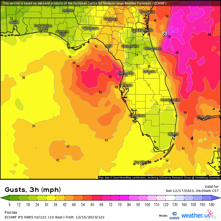
This event is basically similar to a strong tropical storm but won’t be named storm since it is not warm-core, however, it should be getting the same kind of attention. Here is the ECMWF wind gust forecast (Sun 7am EST) with hurricane-force gusts in the Atlantic off NE Florida and strong TS winds over the Eastern Gulf. Gusts to 50mph look quite possible along the west-central and nature coast of Florida and we could see gusts even higher, 55mph+ according to the ECMWF along the immediate coast.
3 likes


Re: Florida Weather
Behind the storm a cold front comes through, bringing the lowest temperatures so far this season to South Florida.
Official NWS forecast as of 4 AM for Miami International Airport
60°F (80% chance of being between 56°F and 65°F) on Monday morning
53°F (80% chance of being between 49°F and 55°F) on Tuesday morning
56°F (80% chance of being between 48°F and 62°F) on Wednesday morning
Official NWS forecast as of 4 AM for Miami International Airport
60°F (80% chance of being between 56°F and 65°F) on Monday morning
53°F (80% chance of being between 49°F and 55°F) on Tuesday morning
56°F (80% chance of being between 48°F and 62°F) on Wednesday morning
1 likes
-
cycloneye

- Admin

- Posts: 139308
- Age: 67
- Joined: Thu Oct 10, 2002 10:54 am
- Location: San Juan, Puerto Rico
Re: Florida Weather
Low taking shape.

0 likes
Visit the Caribbean-Central America Weather Thread where you can find at first post web cams,radars
and observations from Caribbean basin members Click Here
and observations from Caribbean basin members Click Here

Re: Florida Weather
I just started a thread in the Talking Tropics forum about this.
My amateur eyes sees some sub tropical characteristics.
Regardless, we have already have had near tropical storm conditions for the past 24 hours, Gale Warning and wind advisory, coastal flood are in effect. More gusty than sustained winds on the island (Key West) so far only about 35 kt gusts on land. Offshore recently had sustained 33 kt and gusts to 43kts. I would guestimate we have about 2 feet of surge so far.
I am expecting at least one more very heavy squall line sometime today or overnight and with an already astronomically high tide at midnight we might have some moderate flooding.
For us in the Keys, I expect it to start clearing out by tomorrow afternoon but it will still be breezy.
0 likes
-
cycloneye
- Admin
- Posts: 139308
- Age: 67
- Joined: Thu Oct 10, 2002 10:54 am
- Location: San Juan, Puerto Rico
Re: Florida Weather
1 likes
Visit the Caribbean-Central America Weather Thread where you can find at first post web cams,radars
and observations from Caribbean basin members Click Here
and observations from Caribbean basin members Click Here
-
AJC3

- Admin
- Posts: 3873
- Age: 60
- Joined: Tue Aug 31, 2004 7:04 pm
- Location: West Melbourne, Florida
- Contact:
Re: Florida Weather
Jr0d wrote:I just started a thread in the Talking Tropics forum about this.
My amateur eyes sees some sub tropical characteristics.
Regardless, we have already have had near tropical storm conditions for the past 24 hours, Gale Warning and wind advisory, coastal flood are in effect. More gusty than sustained winds on the island (Key West) so far only about 35 kt gusts on land. Offshore recently had sustained 33 kt and gusts to 43kts. I would guestimate we have about 2 feet of surge so far.
I am expecting at least one more very heavy squall line sometime today or overnight and with an already astronomically high tide at midnight we might have some moderate flooding.
For us in the Keys, I expect it to start clearing out by tomorrow afternoon but it will still be breezy.
It's intensifying as a purely extratropical (frontal) low, with absolutely zero chance of it shedding its fronts. Since the system will be impacting multiple states besides Florida, the thread started in TT was moved into this forum order to avoid cross-posting, as alluded to in this recent post about it in the Global Models thread...
https://www.storm2k.org/phpbb2/viewtopi ... 3#p3055573
1 likes
-
gatorcane
- S2K Supporter
- Posts: 23499
- Age: 46
- Joined: Sun Mar 13, 2005 3:54 pm
- Location: Boca Raton, FL
Re: Florida Weather
Strong wind gusts here in Deerfield Beach Island with winds gusting up to 50mph (estimated). Looks like we are getting hit with TS-like conditions with bands and squalls.
0 likes
Re: Florida Weather
Abdullah wrote:Behind the storm a cold front comes through, bringing the lowest temperatures so far this season to South Florida.
Official NWS forecast as of 4 AM for Miami International Airport
60°F (80% chance of being between 56°F and 65°F) on Monday morning
53°F (80% chance of being between 49°F and 55°F) on Tuesday morning
56°F (80% chance of being between 48°F and 62°F) on Wednesday morning
UPDATE forecast created 4 PM December 16
60°F (80% chance of being between 56°F and 65°F) on Monday morning
52°F (80% chance of being between 48°F and 55°F) on Tuesday morning
58°F (80% chance of being between 49°F and 62°F) on Wednesday morning
0 likes
-
HurricaneBelle
- S2K Supporter
- Posts: 975
- Joined: Sun Aug 27, 2006 6:12 pm
- Location: Clearwater, FL
Re: Florida Weather
Looks like the GFS will win this battle with the Euro as the low is about 60 miles west of Pasco County right now and is moving more north than east so it looks like it's headed more toward the Big Bend or even Apalachee Bay than the Nature Coast.
0 likes
Re: Florida Weather
Abdullah wrote:Abdullah wrote:Behind the storm a cold front comes through, bringing the lowest temperatures so far this season to South Florida.
Official NWS forecast as of 4 AM for Miami International Airport
...
UPDATE forecast created 4 PM December 16
60°F (80% chance of being between 56°F and 65°F) on Monday morning
52°F (80% chance of being between 48°F and 55°F) on Tuesday morning
58°F (80% chance of being between 49°F and 62°F) on Wednesday morning
UPDATE forecast created 4 AM December 17
60°F (80% chance of being between 57°F and 63°F) on Monday morning
52°F (80% chance of being between 48°F and 55°F) on Tuesday morning
58°F (80% chance of being between 47°F and 58°F) on Wednesday morning
0 likes
Re: Florida Weather
In the first few weeks of January we also can expect another cold stretch here:

https://i.imgur.com/y1plluk.gif
Starting to show up on ECMWF model runs out to fifteen days:

https://i.imgur.com/y1plluk.gif
Starting to show up on ECMWF model runs out to fifteen days:
1 likes
-
gatorcane
- S2K Supporter
- Posts: 23499
- Age: 46
- Joined: Sun Mar 13, 2005 3:54 pm
- Location: Boca Raton, FL
Re: Florida Weather
Abdullah wrote:In the first few weeks of January we also can expect another cold stretch here:
https://i.imgur.com/y1plluk.gif
https://i.imgur.com/y1plluk.gif
Starting to show up on ECMWF model runs out to fifteen days:
https://i.imgur.com/iEArUto.png
Yep also showing up on the long-range EPS and GEFS, below normal temps starting around Dec 29-30th-ish. It could be an indicator of Florida’s first freeze of the season for Central and North Florida, but with El Niño and an active sub-tropical jet, there could be enough clouds to keep freezes confined more to north Florida and the normally colder interior Cenrtal Florida locations. Also of note the colder anomalies are more over the southern US and Gulf coast (guessing because of more cloud cover and active subtropical jet) with warmer anomalies over the Midwest and north - looks like a very El Niño look on the models as we move into 2024.
1 likes
Re: Florida Weather
It's not going to be cold as long as our source region for cold (great lakes) is torching. It can and will likely be somewhat below normal but this is not a look...at this point...that brings cold our way. It looks like chilly firepit and hoodie weather...which is a nice departure from the blowtorch 2015-16 Nino.
1 likes
-
cycloneye
- Admin
- Posts: 139308
- Age: 67
- Joined: Thu Oct 10, 2002 10:54 am
- Location: San Juan, Puerto Rico
Re: Florida Weather
0 likes
Visit the Caribbean-Central America Weather Thread where you can find at first post web cams,radars
and observations from Caribbean basin members Click Here
and observations from Caribbean basin members Click Here
Re: Florida Weather
Abdullah wrote:Abdullah wrote:Abdullah wrote:Behind the storm a cold front comes through, bringing the lowest temperatures so far this season to South Florida.
Official NWS forecast as of 4 AM for Miami International Airport
...
...
UPDATE forecast created 4 AM December 17
60°F (80% chance of being between 57°F and 63°F) on Monday morning
52°F (80% chance of being between 48°F and 55°F) on Tuesday morning
58°F (80% chance of being between 47°F and 58°F) on Wednesday morning
UPDATE forecast created 4 PM December 17
60°F (80% chance of being between 56°F and 63°F) on Monday morning
52°F (80% chance of being between 48°F and 55°F) on Tuesday morning
58°F (80% chance of being between 49°F and 60°F) on Wednesday morning
0 likes
Re: Florida Weather
Abdullah wrote:Abdullah wrote:Abdullah wrote:
...
...
UPDATE forecast created 4 PM December 17
60°F (80% chance of being between 56°F and 63°F) on Monday morning
52°F (80% chance of being between 48°F and 55°F) on Tuesday morning
58°F (80% chance of being between 49°F and 60°F) on Wednesday morning
Actual low temperature at KMIA on Monday morning: 61°F at 6:00 AM and 7:00 AM
UPDATE forecast created at 4 AM on December 18
52°F (80% chance of being between 48°F and 55°F) on Tuesday morning
59°F (80% chance of being between 51°F and 60°F) on Wednesday morning
0 likes
Re: Florida Weather
Abdullah wrote:Abdullah wrote:Abdullah wrote:
...
...
Actual low temperature at KMIA on Monday morning: 61°F at 6:00 AM and 7:00 AM
UPDATE forecast created at 4 AM on December 18
52°F (80% chance of being between 48°F and 55°F) on Tuesday morning
59°F (80% chance of being between 51°F and 60°F) on Wednesday morning
UPDATE forecast created at 4 PM on December 18
52°F (80% chance of being between 48°F and 55°F) on Tuesday morning
60°F (80% chance of being between 54°F and 62°F) on Wednesday morning
0 likes
Re: Florida Weather
Abdullah wrote:Abdullah wrote:Abdullah wrote:
...
...
UPDATE forecast created at 4 PM on December 18
52°F (80% chance of being between 48°F and 55°F) on Tuesday morning
60°F (80% chance of being between 54°F and 62°F) on Wednesday morning
Actual low temperature at KMIA on Tuesday morning: 55°F at 7:00 AM
0 likes
Return to “USA & Caribbean Weather”
Who is online
Users browsing this forum: A1A, HockeyTx82 and 63 guests