Page 13 of 59
Re: Texas Spring 2024
Posted: Sun Mar 24, 2024 11:31 am
by Ntxw
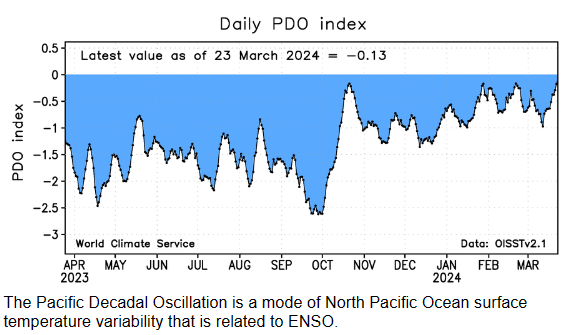
It's the lagging effects of Nino. The coming Nina will tug it more negative as the year goes on though. There really isn't a year that goes very Nina that starts with -PDO with a flip.
Re: Texas Spring 2024
Posted: Sun Mar 24, 2024 12:34 pm
by Ntxw
For the major population centers of Texas it's been a pretty good start to the year in terms of rain. This is comforting in that it opens up the Nino->Nina transition years with -PDO such as 1973, and 2007 that were cool, wet summers and overall wet years. Had we started dry, then the pool would've been less forgiving.

Re: Texas Spring 2024
Posted: Sun Mar 24, 2024 1:01 pm
by ElectricStorm
Pretty nice non severe storm over me now
Re: Texas Spring 2024
Posted: Sun Mar 24, 2024 4:40 pm
by txtwister78
Storm southwest of Vernon means business. A little better environment just south of the river into TX. Probably the one to watch over the next hour for possible tornado development.
Re: Texas Spring 2024
Posted: Sun Mar 24, 2024 5:44 pm
by txtwister78
txtwister78 wrote:Storm southwest of Vernon means business. A little better environment just south of the river into TX. Probably the one to watch over the next hour for possible tornado development.
There it is...tornado warned now west of Wichita Falls.
Re: Texas Spring 2024
Posted: Sun Mar 24, 2024 9:20 pm
by bubba hotep
Watch up for DFW until 3:00 am
Re: Texas Spring 2024
Posted: Sun Mar 24, 2024 9:50 pm
by Brent
Finally a lightning strike

The real surprise today has been the lack of strong wind here
Re: Texas Spring 2024
Posted: Sun Mar 24, 2024 11:46 pm
by ElectricStorm
Multiple rounds of nice non-severe storms here today, pretty good for a marginal risk. I expected a little more in western OK today but it just didn't happen and most of the enhanced risk didn't see much at all. That being said, looks like there were a few tornadoes in TX and KS so it wasn't a complete bust.
Re: Texas Spring 2024
Posted: Mon Mar 25, 2024 12:09 am
by Brent
Oh now it's windy on the back side of the rain
Re: Texas Spring 2024
Posted: Mon Mar 25, 2024 7:07 am
by snownado
As rainy as this March has been for DFW (5.63"), we're still 0.11" shy of cracking the Top 10 Wettest list.
If it doesn't happen with the light/moderate stratiform rain this morning, it'll end up just short with the rest of the month looking dry.
Re: Texas Spring 2024
Posted: Mon Mar 25, 2024 8:25 am
by Iceresistance
Just over an inch in DFW International Airport
Re: Texas Spring 2024
Posted: Mon Mar 25, 2024 10:23 am
by Iceresistance
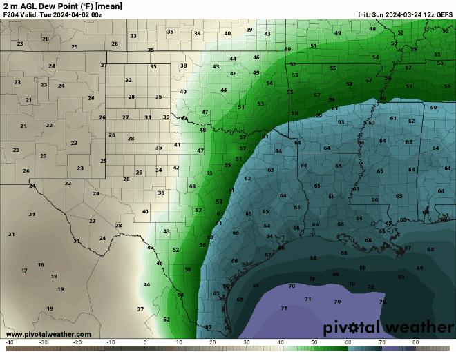
Abnormally strong signal for April 1st (
THIS IS NOT AN APRIL FOOLS JOKE)
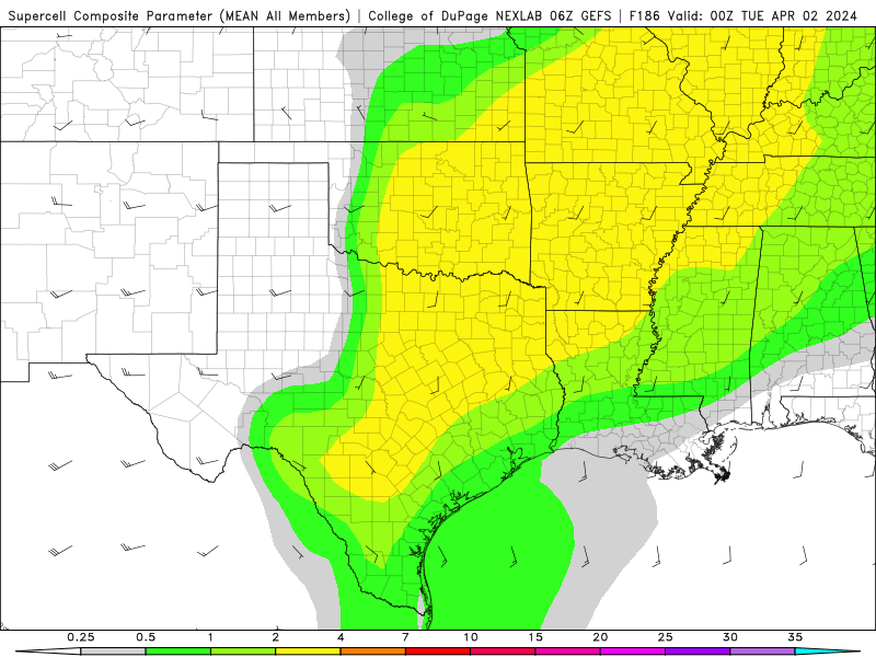 https://s9.gifyu.com/images/SV3Ns.png
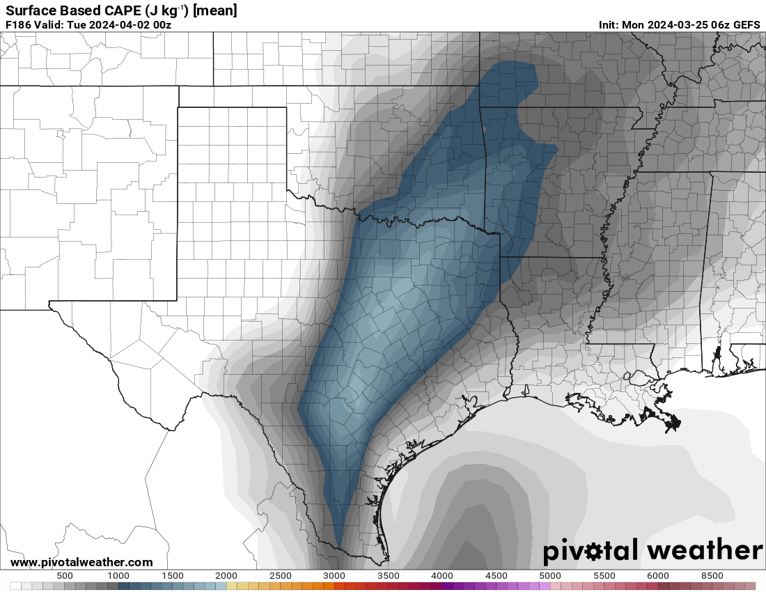 https://s9.gifyu.com/images/SV3Nh.png
Not imaged, but Shear is over 60 knots.
Dewpoint is trending west too.
 https://s12.gifyu.com/images/SV3NT.gif
Re: Texas Spring 2024
Posted: Mon Mar 25, 2024 10:46 am
by CaptinCrunch
April and May are our typical severe months
Re: Texas Spring 2024
Posted: Mon Mar 25, 2024 10:57 am
by ElectricStorm
Yeah I saw that but not getting excited yet since it's still a week out.
Re: Texas Spring 2024
Posted: Mon Mar 25, 2024 11:00 am
by rwfromkansas
That is an impressive signal, but it's a week out.
Re: Texas Spring 2024
Posted: Mon Mar 25, 2024 11:09 am
by Ntxw
Looks like a cold trough though, might be chilly start to April.
Re: Texas Spring 2024
Posted: Mon Mar 25, 2024 11:36 am
by Iceresistance
The SPC is aware of this
By Day 7/Sunday into Day 8/Monday, most medium-range guidance shows
an upper trough/low moving from the eastern Pacific across the
western states. There appears to be a somewhat bimodal distribution
in various GFS/GEFS and ECMWF/EPS solutions regarding the eventual
ejection of this upper trough across the southern/central Plains.
Some guidance shows a more positively tilted and elongated upper
trough evolution, which could still support severe potential across
the southern/central Plains by early next week. Other solutions show
a more compact, neutral to negatively tilted trough ejection.
Stronger low-level mass response in this scenario would lead to
greater low-level moisture return, related stronger instability east
of a dryline, and a potentially better setup for severe convection
next Monday. Regardless, predictability remains far too low to add a
15% severe delineation at this extended time frame. But, trends will
be monitored.
Re: Texas Spring 2024
Posted: Mon Mar 25, 2024 2:59 pm
by captainbarbossa19

You do have to look at more teleconnections aside from ENSO, but this is a good sign for those who like rain in Texas.
Re: Texas Spring 2024
Posted: Mon Mar 25, 2024 10:16 pm
by Brent
Winter is back here apparently

Other than the weekend not much warm air
Re: Texas Spring 2024
Posted: Tue Mar 26, 2024 7:36 am
by Yukon Cornelius
Light freeze this morning. Made it down to 31.