Texas Spring 2024

U.S. & Caribbean Weather Discussions and Severe Weather Events

Moderator: S2k Moderators

Forum rules

The posts in this forum are NOT official forecast and should not be used as such. They are just the opinion of the poster and may or may not be backed by sound meteorological data. They are NOT endorsed by any professional institution or STORM2K.

Help Support Storm2K
Message
Author
User avatar
bubba hotep
S2K Supporter
S2K Supporter
Posts: 5526
Joined: Wed Dec 28, 2016 1:00 am
Location: Collin County Texas

Re: Texas Spring 2024

#1041 Postby bubba hotep » Sun May 05, 2024 9:04 am

DallasAg wrote:
bubba hotep wrote:00z HRRR gets a lot of people rain overnight and into tomorrow morning.

https://m2o.pivotalweather.com/maps/models/hrrr/2024050500/040/qpf_acc-imp.us_sc.png

3.74" IMBY North Dallas about 5 miles ENE from KDAL. Seems like Dallas County has consistently been the winner this spring. Hopefully a drier week ahead.

Tbh, the last 3-4 weeks have reminded me of what I remember spring being like in Texas when I was growing up (Plano), especially with all of the activity that west Texas has been getting. Daily severe weather, mostly way west of us, organizing into squall lines or MCS that sweep in over night. In various forms or fashions through June. In a world where nothing is like it used to be, it's nice to see something familiar.

Now if Mother Nature can find a way to fill in the holes for those who've missed out hopefully we can enter summer with enough of a surplus to stave off the heat dome or at least delay its onset.


Just over an inch at DFW, but Love picked up 3.5"
0 likes   
Winter time post are almost exclusively focused on the DFW area.

User avatar
South Texas Storms
Professional-Met
Professional-Met
Posts: 4018
Joined: Thu Jun 24, 2010 12:28 am
Location: Houston, TX

Re: Texas Spring 2024

#1042 Postby South Texas Storms » Sun May 05, 2024 9:18 am

Looking like another bust in SA and the Hill Country. What a cruel joke. This area just can't catch a break and as a result some areas of severe drought just won't go away.
2 likes   

User avatar
ElectricStorm
Category 5
Category 5
Posts: 4593
Age: 23
Joined: Tue Aug 13, 2019 11:23 pm
Location: Skiatook, OK / Norman, OK

Re: Texas Spring 2024

#1043 Postby ElectricStorm » Sun May 05, 2024 9:22 am

12z HRRR is just downright nasty with what looks like 2 rounds of supercells for OK with an overnight threat for the eastern half of the state. Also more of a semi-discrete mode in KS. Wouldn't be surprised to see the moderate expanded east. Starting to get a little more concerned now
1 likes   
I am in no way a professional. Take what I say with a grain of salt as I could be totally wrong. Please refer to the NHC, NWS, or SPC for official information.

Boomer Sooner!

User avatar
bubba hotep
S2K Supporter
S2K Supporter
Posts: 5526
Joined: Wed Dec 28, 2016 1:00 am
Location: Collin County Texas

Re: Texas Spring 2024

#1044 Postby bubba hotep » Sun May 05, 2024 9:39 am

South Texas Storms wrote:Looking like another bust in SA and the Hill Country. What a cruel joke. This area just can't catch a break and as a result some areas of severe drought just won't go away.


Yeah, it's starting to look like South Texas might have to bet on an active tropical season, which does seem likely.
1 likes   
Winter time post are almost exclusively focused on the DFW area.

rwfromkansas
Category 5
Category 5
Posts: 2222
Joined: Sat Aug 27, 2005 12:47 am
Location: North Fort Worth

Re: Texas Spring 2024

#1045 Postby rwfromkansas » Sun May 05, 2024 9:42 am

Well, that’s that for TX for awhile. Yeah, there are “chances” every day this week, but more summer popcorn storms. I’m betting most see nothing. OK and KS will get a lot though.

Hopefully rain comes back before the heat ridge.
0 likes   

Cpv17
Category 5
Category 5
Posts: 4372
Joined: Wed Dec 07, 2016 2:24 pm
Location: Wharton/El Campo, TX

Re: Texas Spring 2024

#1046 Postby Cpv17 » Sun May 05, 2024 10:20 am

South Texas Storms wrote:Looking like another bust in SA and the Hill Country. What a cruel joke. This area just can't catch a break and as a result some areas of severe drought just won't go away.


I wouldn’t write it off yet.
1 likes   

Ntxw
Storm2k Moderator
Storm2k Moderator
Posts: 21523
Joined: Wed Oct 21, 2009 6:34 pm
Location: DFW, Texas

Re: Texas Spring 2024

#1047 Postby Ntxw » Sun May 05, 2024 10:31 am

The eastern and northeastern half of the state is doing very well rainfall rise. Most are sitting at 15-25" for the year with several sites already over 30" in east and far southeast Texas.

Mid May will feature an anomalous cutoff trough over the north-central and central conus resulting in cooler than normal period coming up.

Image

Image
6 likes   
The above post and any post by Ntxw is NOT an official forecast and should not be used as such. It is just the opinion of the poster and may or may not be backed by sound meteorological data. It is NOT endorsed by any professional institution including Storm2k. For official information, please refer to NWS products.

  Help support Storm2K!
Help Support Storm2K

User avatar
txtwister78
Category 5
Category 5
Posts: 1059
Joined: Wed Jan 30, 2019 12:56 pm
Location: San Antonio

Re: Texas Spring 2024

#1048 Postby txtwister78 » Sun May 05, 2024 10:53 am

While coverage may not be as widespread as models had depicted yesterday, storms are beginning to fire across the SA metro.
2 likes   

User avatar
CaptinCrunch
S2K Supporter
S2K Supporter
Posts: 8579
Age: 56
Joined: Mon Nov 03, 2003 4:33 pm
Location: Lake Worth, TX (Tarrant Co.)

Re: Texas Spring 2024

#1049 Postby CaptinCrunch » Sun May 05, 2024 11:03 am

The rain is welcomed, but I need a dry slot now. It will take 2 weeks for the ground to dry out. Both front and back yards are standing in 2-3" of water in the lowest spots.

Received about 3" of rain over night, which makes 2 of the last 3 weekend multi inch rains here at the house.

Where the I20/820/287 construction project is, the river under I20 is several feet above out of its banks and the equipment sitting under the bridges are just islands.
2 likes   

User avatar
Texas Snowman
Storm2k Moderator
Storm2k Moderator
Posts: 6041
Joined: Fri Jan 25, 2008 11:29 am
Location: Denison, Texas

Re: Texas Spring 2024

#1050 Postby Texas Snowman » Sun May 05, 2024 12:35 pm

Tomorrow certainly seems to be shaping up as a dangerous weather day from the Red River to the north…

 https://x.com/mikemorgankfor/status/1787172489908404514


0 likes   
The above post and any post by Texas Snowman is NOT an official forecast and should not be used as such. It is just the opinion of the poster and may or may not be backed by sound meteorological data. It is NOT endorsed by any professional institution including storm2k.org. For official information, please refer to NWS products.

Anti-freeze
Tropical Depression
Tropical Depression
Posts: 63
Joined: Tue Jan 02, 2024 8:26 pm

Re: Texas Spring 2024

#1051 Postby Anti-freeze » Sun May 05, 2024 12:37 pm

rwfromkansas wrote:
mmmmsnouts wrote:This is wild - 3 feet of hail east of San Angelo reported by NWS in a flash flood warning:

https://kamala.cod.edu/offs/KSJT/2405050134.wgus54.html


I haven’t seen any photos of this. I call shenanigans.

If there was 3 feet, there would be photos.

3 inches I could see.


It seems to be a wild exaggeration. Is NWS San Angelo now run by clown show storm chasers? They doubled down on their claim with photos that show only a small layer of hail, maybe a few inches. The equivalent of a chaser streaming an EF1 and exclaiming, "Wow! Massive mile wide wedge tornado!"

 https://twitter.com/NWSSanAngelo/status/1786955636598878415


Here's the original source with video that gives better context.

https://www.facebook.com/100029301141196/posts/pfbid02Amw3jh4PgnvjRYrBwV2yD7Hupa9e3qe6fixJEueUjQKySirKfY1ShEYTnMiPDhbTl/?mibextid=WC7FNe

(Facebook, but I was able to click away the login screen to see the videos)
Last edited by Anti-freeze on Sun May 05, 2024 1:14 pm, edited 1 time in total.
0 likes   

lukem
Tropical Storm
Tropical Storm
Posts: 116
Joined: Wed Feb 17, 2010 2:53 pm

Re: Texas Spring 2024

#1052 Postby lukem » Sun May 05, 2024 12:53 pm

Fifty Rock wrote:Can’t seem to find rainfall totals for shackelford county texas


We had 1.8 inches in one pasture about 8 miles SE of Albany. Eastern part of the ranch only got 1.1 inches. Definitely rained more closer to town.
0 likes   

Cpv17
Category 5
Category 5
Posts: 4372
Joined: Wed Dec 07, 2016 2:24 pm
Location: Wharton/El Campo, TX

Re: Texas Spring 2024

#1053 Postby Cpv17 » Sun May 05, 2024 1:41 pm

Anti-freeze wrote:
rwfromkansas wrote:
mmmmsnouts wrote:This is wild - 3 feet of hail east of San Angelo reported by NWS in a flash flood warning:

https://kamala.cod.edu/offs/KSJT/2405050134.wgus54.html


I haven’t seen any photos of this. I call shenanigans.

If there was 3 feet, there would be photos.

3 inches I could see.


It seems to be a wild exaggeration. Is NWS San Angelo now run by clown show storm chasers? They doubled down on their claim with photos that show only a small layer of hail, maybe a few inches. The equivalent of a chaser streaming an EF1 and exclaiming, "Wow! Massive mile wide wedge tornado!"

https://twitter.com/NWSSanAngelo/status/1786955636598878415

Here's the original source with video that gives better context.

https://www.facebook.com/100029301141196/posts/pfbid02Amw3jh4PgnvjRYrBwV2yD7Hupa9e3qe6fixJEueUjQKySirKfY1ShEYTnMiPDhbTl/?mibextid=WC7FNe

(Facebook, but I was able to click away the login screen to see the videos)


I completely agree. That’s not even close to one foot, yet alone 3 feet. They’re trippin balls lol
0 likes   

Anti-freeze
Tropical Depression
Tropical Depression
Posts: 63
Joined: Tue Jan 02, 2024 8:26 pm

Re: Texas Spring 2024

#1054 Postby Anti-freeze » Sun May 05, 2024 1:47 pm

Navasota River near Easterly crested over 1.5' above the previous record, near Normandy almost 3' above the record.

So far the Brazos below the merge is not as bad, Hempstead forecast to crest 9' below record, similar for near I-10 at San Felipe. Richmond projections don't go far enough out for a crest, but on Friday are predicted to be 11' below the record, not quite at the minor flood stage. However, the I-69 crossing is projected to 67.7'' on Friday, within a foot of the moderate flooding stage. Maybe these counties allowing developers to fill in most of the floodplain, leaving just a small levee protected channel, wasn't a wise decision...

Elsewhere, the Trinity may be cresting now at Liberty, about 6 inches below their record. Projected to flirt with the highest level at Moss Bluff, and came within about an inch of the record at US 59 near Shepherd. The San Jacinto is receding at I-45, I-69, and at Sheldon, 5', 10', and 9' below records. E. Fork of the San Jacinto at the Grand Parkway is also receding, it came within 3.5' of the record.

https://water.noaa.gov/
0 likes   

User avatar
South Texas Storms
Professional-Met
Professional-Met
Posts: 4018
Joined: Thu Jun 24, 2010 12:28 am
Location: Houston, TX

Re: Texas Spring 2024

#1055 Postby South Texas Storms » Sun May 05, 2024 2:00 pm

Cpv17 wrote:
South Texas Storms wrote:Looking like another bust in SA and the Hill Country. What a cruel joke. This area just can't catch a break and as a result some areas of severe drought just won't go away.


I wouldn’t write it off yet.


I'm afraid it's over. Same general areas keep getting screwed over. Very frustrating.
0 likes   

User avatar
txtwister78
Category 5
Category 5
Posts: 1059
Joined: Wed Jan 30, 2019 12:56 pm
Location: San Antonio

Re: Texas Spring 2024

#1056 Postby txtwister78 » Sun May 05, 2024 2:30 pm

South Texas Storms wrote:
Cpv17 wrote:
South Texas Storms wrote:Looking like another bust in SA and the Hill Country. What a cruel joke. This area just can't catch a break and as a result some areas of severe drought just won't go away.


I wouldn’t write it off yet.


I'm afraid it's over. Same general areas keep getting screwed over. Very frustrating.


That MCS hurt us overnight. Worked over/stabilized atmosphere across SA and areas across southern HC. Timing has really hurt our cause as well. If we're not getting much today (seems more likely now), at least areas southwest and south are getting some much-needed rainfall.
2 likes   

Cpv17
Category 5
Category 5
Posts: 4372
Joined: Wed Dec 07, 2016 2:24 pm
Location: Wharton/El Campo, TX

Re: Texas Spring 2024

#1057 Postby Cpv17 » Sun May 05, 2024 2:43 pm

South Texas Storms wrote:
Cpv17 wrote:
South Texas Storms wrote:Looking like another bust in SA and the Hill Country. What a cruel joke. This area just can't catch a break and as a result some areas of severe drought just won't go away.


I wouldn’t write it off yet.


I'm afraid it's over. Same general areas keep getting screwed over. Very frustrating.


Most likely, a tropical system will come and flood all of STX in a few months. That’s how it works.
1 likes   

User avatar
Edwards Limestone
S2K Supporter
S2K Supporter
Posts: 373
Age: 35
Joined: Tue Dec 28, 2021 11:05 am
Location: Smithson Valley, TX

Re: Texas Spring 2024

#1058 Postby Edwards Limestone » Sun May 05, 2024 3:16 pm

Yeah I don’t think the drought is going away anytime soon down here. As soon as I saw that outflow emerging off the MCS last night I knew we were screwed. Completely stabilized everything.

I was “lucky” enough to still pick up 0.4” at least. Did better than most in my area.

I don’t even care anymore, just ready to get rid of this awful humidity. I’d rather it just be dry if it won’t actually rain.
1 likes   
The above post is NOT an official forecast and should not be used as such. It is just the opinion of the poster and may or may not be backed by sound meteorological data. It is NOT endorsed by any professional institution including Storm2k. For official information, please refer to NWS products.

User avatar
bubba hotep
S2K Supporter
S2K Supporter
Posts: 5526
Joined: Wed Dec 28, 2016 1:00 am
Location: Collin County Texas

Re: Texas Spring 2024

#1059 Postby bubba hotep » Sun May 05, 2024 5:03 pm

Was looking forward to the dry out and the WPC drops this on us

Image

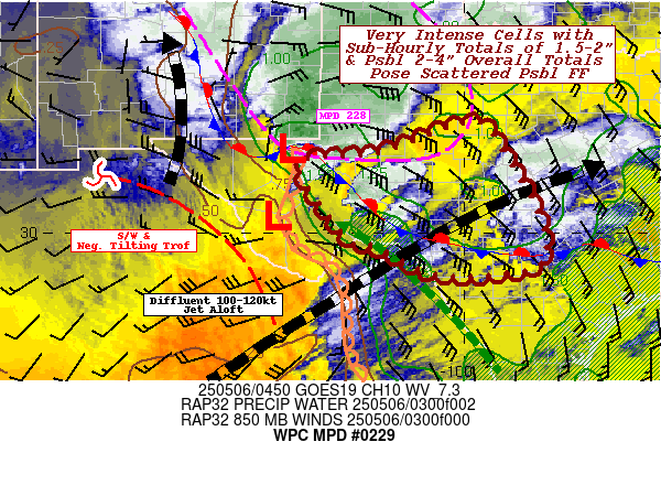
Mesoscale Precipitation Discussion 0229
NWS Weather Prediction Center College Park MD
553 PM EDT Sun May 05 2024

Areas affected...central to northeastern TX

Concerning...Heavy rainfall...Flash flooding possible

Valid 052152Z - 060200Z

SUMMARY...Highly localized flash flooding may result over the next
3-5 hours from thunderstorms producing 1-2 in/hr rates atop
saturated soils. Coverage of storms and their organization appears
lower end, but recent heavy rainfall has increased the potential
for runoff across portions of central to northeastern TX.

DISCUSSION...Visible satellite imagery and lightning data
indicated widely scattered thunderstorms over portions of central
and eastern TX at 2145Z within a relatively clear region
accompanied by 1000 to 2000+ J/kg MLCAPE over central to
eastern/northeastern TX via the 21Z SPC mesoanalysis. These storms
were forming within a zone of elevated convergence, in the wake of
a departing upper level shortwave over the eastern TX/OK border.
Despite the weak axis of low level forcing, subsidence behind the
shortwave and an unfavorable upper level jet orientation makes
this region of TX hostile to high coverage of thunderstorm
development.

Nonetheless, the zone of elevated convergence is expected to drift
north over the next few hours with additional thunderstorm
development appearing likely via an existing cell over Robertson
County near Hearne (which produced 1.18 inches of rain in an hour
ending 2134Z...via Wunderground.com), and agitated cumulus on
visible imagery. Coverage of cells is likely to remain scattered
in nature through the evening, but some slow movement of any
robust cells that form may support 1-2 in/hr rainfall rates, on a
highly localized basis. Dissipation of any thunderstorms should
occur after sunset with the loss of daytime heating.

Heavy rain over the past 10 days or so across central to
northeastern TX, including 3 to 5+ inches over the past 24 hours
to the west of I-35, has resulted in saturated soils and reduced
infiltration capacity of additional rainfall. Any areas of renewed
flash flooding that occur are expected to remain localized and
likely lower end in magnitude.

Otto

ATTN...WFO...EWX...FWD...HGX...SHV...SJT...

ATTN...RFC...WGRFC...NWC...
0 likes   
Winter time post are almost exclusively focused on the DFW area.

rwfromkansas
Category 5
Category 5
Posts: 2222
Joined: Sat Aug 27, 2005 12:47 am
Location: North Fort Worth

Re: Texas Spring 2024

#1060 Postby rwfromkansas » Sun May 05, 2024 7:52 pm

What looked like the first stretch of real 90s for DFW has evaporated in the humidity to just upper 80s now. And really just one day.
Last edited by rwfromkansas on Sun May 05, 2024 8:06 pm, edited 1 time in total.
0 likes   


Return to “USA & Caribbean Weather”

Who is online

Users browsing this forum: AnnularCane, rwfromkansas and 7 guests