Texas Spring 2024
Moderator: S2k Moderators
Forum rules

The posts in this forum are NOT official forecast and should not be used as such. They are just the opinion of the poster and may or may not be backed by sound meteorological data. They are NOT endorsed by any professional institution or STORM2K.
-
txtwister78

- Category 5

- Posts: 1059
- Joined: Wed Jan 30, 2019 12:56 pm
- Location: San Antonio
Re: Texas Spring 2024
Several tornado warnings out for western Missouri including eastern areas of Kansas City metro and one confirmed NE of Joplin.
0 likes
-
txtwister78
- Category 5
- Posts: 1059
- Joined: Wed Jan 30, 2019 12:56 pm
- Location: San Antonio
Re: Texas Spring 2024
So far 60-69 gust reports coming out of Moore/OKC Metro. Stom continues to bow out moving east so no question isolated wind threat within that region as mentioned earlier, but the other storms have weakened south. Man, that storm is hauling east.
0 likes

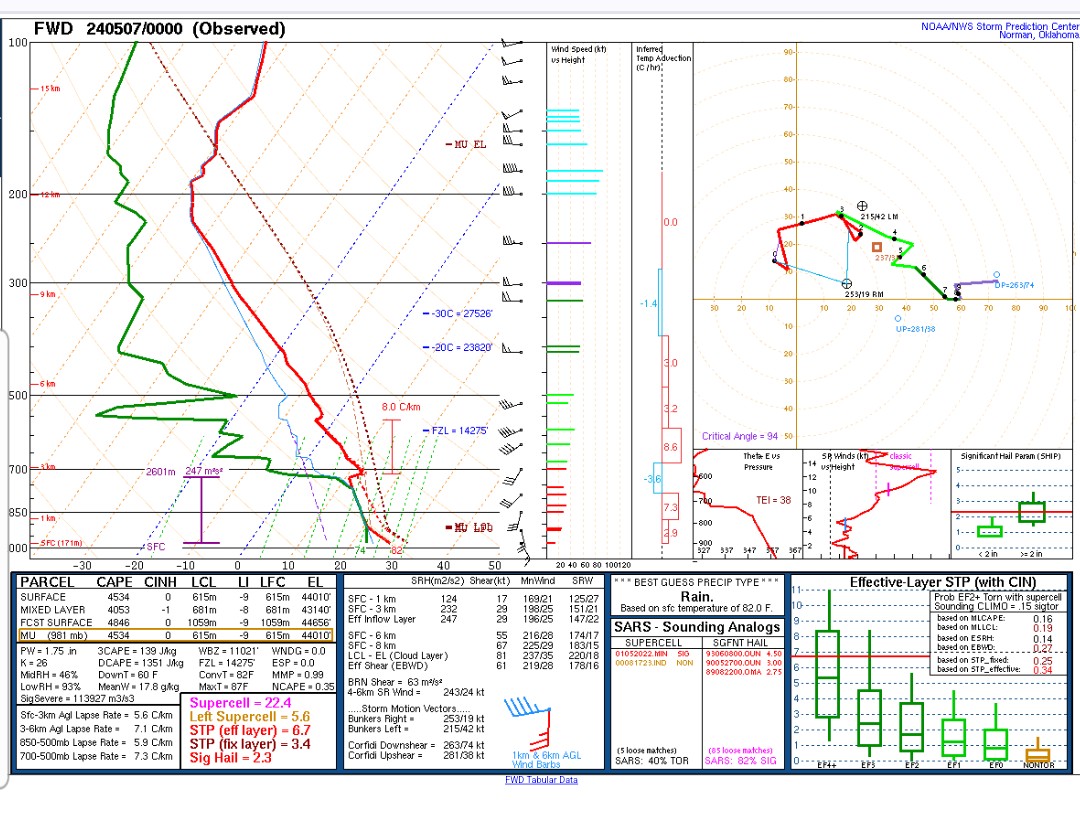
Re: Texas Spring 2024
It's a good thing there was was virtually no trigger mechanism to force convection in North Texas (the best lift/ascent/dynamics was well NW into OK and KS). That 00z FWD sounding was one of the nastiest I've ever seen, with negligible capping at best.
0 likes
-
rwfromkansas
- Category 5
- Posts: 2223
- Joined: Sat Aug 27, 2005 12:47 am
- Location: North Fort Worth
Re: Texas Spring 2024
snownado wrote:It's a good thing there was was virtually no trigger mechanism to force convection in North Texas (the best lift/ascent/dynamics was well NW into OK and KS). That 00z FWD sounding was one of the nastiest I've ever seen, with negligible capping at best.
https://www.americanwx.com/bb/uploads/monthly_2024_05/Screenshot_20240506_201211.jpg.4eb61d31768f6b29555072fea4532c27.jpg
Just, wow. Yes, sometimes I bemoan lack of severe storms, but not tornadoes. That was a scary sounding.
0 likes
-
Anti-freeze
- Tropical Depression

- Posts: 63
- Joined: Tue Jan 02, 2024 8:26 pm
Re: Texas Spring 2024

0 likes
Re: Texas Spring 2024
As of 11am, it's already 85*F at DFW. This is before the dewpoints start mixing down (compressional heating) and with mostly clear skies.
Will it make a run for 90*F after all today? Will find out soon...
Will it make a run for 90*F after all today? Will find out soon...
0 likes
-
rwfromkansas
- Category 5
- Posts: 2223
- Joined: Sat Aug 27, 2005 12:47 am
- Location: North Fort Worth
Re: Texas Spring 2024
rwfromkansas wrote:It's 89 IMBY, so pretty much guaranteed to hit 90, probably 92-93.
At least it isn't humid today. Feels ok out there. Tomorrow is a different story though. The weekend temps look fantastic.
0 likes

Re: Texas Spring 2024
gpsnowman wrote:rwfromkansas wrote:It's 89 IMBY, so pretty much guaranteed to hit 90, probably 92-93.
At least it isn't humid today. Feels ok out there. Tomorrow is a different story though. The weekend temps look fantastic.
It's 87F/75F in Longview with 67% humidity at 1 pm. Definitely humid over here!
0 likes
-
Yukon Cornelius
- S2K Supporter

- Posts: 1738
- Age: 40
- Joined: Thu Dec 20, 2012 9:23 pm
- Location: Dean, TX/Westcliffe, CO
Re: Texas Spring 2024
Dang, and here I thought 80 currently is way too hot feeling. I’m ready for overcast skies again and rain.
0 likes
#neversummer
Re: Texas Spring 2024
Only 89*F at DFW as of the 2pm observation. Dewpoint creeped back up ever so slightly though.
0 likes
-
Edwards Limestone

- S2K Supporter
- Posts: 373
- Age: 35
- Joined: Tue Dec 28, 2021 11:05 am
- Location: Smithson Valley, TX
Re: Texas Spring 2024

Mesoscale Discussion 0678
NWS Storm Prediction Center Norman OK
0205 PM CDT Tue May 07 2024
Areas affected...parts of central Texas
Concerning...Severe potential...Watch possible
Valid 071905Z - 072130Z
Probability of Watch Issuance...40 percent
SUMMARY...Isolated storms may develop by late afternoon, with a
conditional threat of very large hail. A small Slight Risk is also
being added to the 20Z convective outlook.
DISCUSSION...Surface analysis shows a stationary front from Dallas
southwestward toward Del Rio, with generally weak wind convergence.
Ample low-level moisture exists south and east of the boundary, with
70s F dewpoints and MLCAPE in excess of 3000 J/kg. Convective
inhibition continues to decrease due to heating, as temperature rise
into the upper 80s to near 90 F.
Visible imagery shows increasing CU fields west of the I-35 corridor
from Austin to San Antonio, particularly along the west edge of a
thicker but eroding cloud deck.
Over the next few hours, isolated severe storms may form over this
small region. Relatively long and straight hodographs along with the
deepening moist boundary layer and very strong instability will
conditionally support very large hail. Splitting cells may occur as
well, with left movers also producing hail.
..Jewell/Smith.. 05/07/2024
https://www.spc.noaa.gov/products/md/md0678.html
1 likes
The above post is NOT an official forecast and should not be used as such. It is just the opinion of the poster and may or may not be backed by sound meteorological data. It is NOT endorsed by any professional institution including Storm2k. For official information, please refer to NWS products.
-
ElectricStorm

- Category 5
- Posts: 4594
- Age: 23
- Joined: Tue Aug 13, 2019 11:23 pm
- Location: Skiatook, OK / Norman, OK
Re: Texas Spring 2024
0 likes
I am in no way a professional. Take what I say with a grain of salt as I could be totally wrong. Please refer to the NHC, NWS, or SPC for official information.
Boomer Sooner!
Boomer Sooner!
Re: Texas Spring 2024
DFW reached an intra-hour high of 91*F at 1:32pm today, overachieving by several degrees.
1 likes
-
txtwister78
- Category 5
- Posts: 1059
- Joined: Wed Jan 30, 2019 12:56 pm
- Location: San Antonio
Re: Texas Spring 2024
Edwards Limestone wrote:https://www.spc.noaa.gov/products/md/mcd0678.pngMesoscale Discussion 0678
NWS Storm Prediction Center Norman OK
0205 PM CDT Tue May 07 2024
Areas affected...parts of central Texas
Concerning...Severe potential...Watch possible
Valid 071905Z - 072130Z
Probability of Watch Issuance...40 percent
SUMMARY...Isolated storms may develop by late afternoon, with a
conditional threat of very large hail. A small Slight Risk is also
being added to the 20Z convective outlook.
DISCUSSION...Surface analysis shows a stationary front from Dallas
southwestward toward Del Rio, with generally weak wind convergence.
Ample low-level moisture exists south and east of the boundary, with
70s F dewpoints and MLCAPE in excess of 3000 J/kg. Convective
inhibition continues to decrease due to heating, as temperature rise
into the upper 80s to near 90 F.
Visible imagery shows increasing CU fields west of the I-35 corridor
from Austin to San Antonio, particularly along the west edge of a
thicker but eroding cloud deck.
Over the next few hours, isolated severe storms may form over this
small region. Relatively long and straight hodographs along with the
deepening moist boundary layer and very strong instability will
conditionally support very large hail. Splitting cells may occur as
well, with left movers also producing hail.
..Jewell/Smith.. 05/07/2024
https://www.spc.noaa.gov/products/md/md0678.html
Can definitely see some cumulus bubbling up just NW of San Antonio across the southern HC. Might get one to fire up there but odds still low overall. May have to wait until Thursday for some slightly better odds. Don't even want to go beyond that time period for hope because that may jinx us...lol
2 likes
-
txtwister78
- Category 5
- Posts: 1059
- Joined: Wed Jan 30, 2019 12:56 pm
- Location: San Antonio
Re: Texas Spring 2024
Unfortunately, we have a mini tornado outbreak occurring today across Michigan and Indiana. Different storm modes across that region than what we saw yesterday for the most part.
0 likes
-
Anti-freeze
- Tropical Depression
- Posts: 63
- Joined: Tue Jan 02, 2024 8:26 pm
Re: Texas Spring 2024
snownado wrote:DFW reached an intra-hour high of 91*F at 1:32pm today, overachieving by several degrees.
"Don't care, had low dew point."
Interesting at the range of dewpoints across greater DFW. Rockwell currently at 67, Love Field 62, DFW Airport 56, Alliance Airport 44.
The living is great on the drier side of the Metroplex.
0 likes
Re: Texas Spring 2024
Anti-freeze wrote:snownado wrote:DFW reached an intra-hour high of 91*F at 1:32pm today, overachieving by several degrees.
"Don't care, had low dew point."
Interesting at the range of dewpoints across greater DFW. Rockwell currently at 67, Love Field 62, DFW Airport 56, Alliance Airport 44.
The living is great on the drier side of the Metroplex.
I was just happy to finally have a sunny day again. The 90*F+ high was merely icing on the cake.
1 likes
-
cheezyWXguy

- Category 5
- Posts: 5556
- Joined: Mon Feb 13, 2006 12:29 am
- Location: Dallas, TX
Re: Texas Spring 2024
0z hrrr firing of supercells in Dallas county and points northeast tomorrow between 5 and 6pm. With weak low level shear, strong bulk shear, and almost 7000j/kg of cape, these would drop some giant hail on whoever is under them. Wouldn’t be surprised if the eastern metro gets bumped up to enhanced but I could see them keeping it a slight due to low confidence in coverage until the best dynamics have moved east.
Edit: with the 0z nam following suit on westward expansion, I’d think there’s a decent chance of the enhanced risk being pulled west to i35 tomorrow
Edit: with the 0z nam following suit on westward expansion, I’d think there’s a decent chance of the enhanced risk being pulled west to i35 tomorrow
1 likes
Re: Texas Spring 2024
cheezyWXguy wrote:0z hrrr firing of supercells in Dallas county and points northeast tomorrow between 5 and 6pm. With weak low level shear, strong bulk shear, and almost 7000j/kg of cape, these would drop some giant hail on whoever is under them. Wouldn’t be surprised if the eastern metro gets bumped up to enhanced but I could see them keeping it a slight due to low confidence in coverage until the best dynamics have moved east.
Edit: with the 0z nam following suit on westward expansion, I’d think there’s a decent chance of the enhanced risk being pulled west to i35 tomorrow
Moderate could be added for points east. Tomorrow is looking nasty.
0 likes
Return to “USA & Caribbean Weather”
Who is online
Users browsing this forum: No registered users and 9 guests