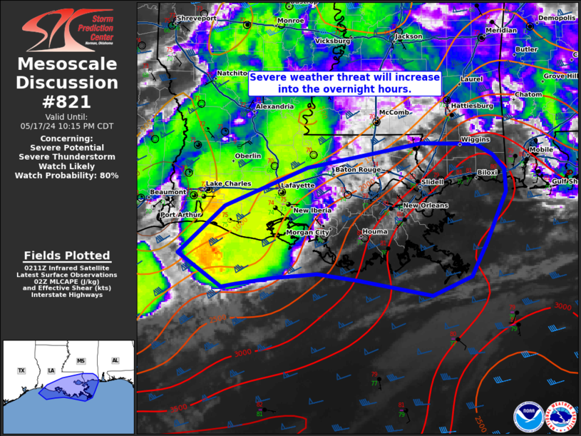
Mesoscale Discussion 0821
NWS Storm Prediction Center Norman OK
1249 PM CDT Fri May 19 2023
Areas affected...portions of southeastern Oklahoma and the ArkLaTex
Concerning...Severe potential...Severe Thunderstorm Watch likely
Valid 191749Z - 191915Z
Probability of Watch Issuance...95 percent
SUMMARY...Scattered severe storms, including supercells, are
expected to develop this afternoon in the wake of an early morning
MCS. Large hail is expected to be the primary threat, though
isolated damaging gusts and a tornado cannot be ruled out. A Severe
Thunderstorm Watch is likely this afternoon.
DISCUSSION...In the wake of an early morning MCS and remnant MCV
across eastern OK and the ArkLaTex, clearing skies have aided in
rapid recovery of the air mass early this afternoon. Strong
insolation has allowed surface temperatures to warm into the 70s F
with dewpoints remaining in the low to mid 60s F. Continued
modification of the air mass is likely through the next couple of
hours, supporting the development of 1500-2000 J/kg of MLCAPE. As
instability develops and lingering inhibition is removed, the
development of severe storms is likely across a couple of areas this
afternoon.
Aided by the remnant MCV, area VAD/VWPs show moderate effective
shear (30-40 kt) sufficient for storm organization, including
supercells. Storms may first develop ahead of the remnant MCV across
eastern OK before spreading eastward into AR. A few storms may also
develop on the trailing outflow near the Red River and possibly as
far west as central OK. Despite the poor mid-level lapse rates, the
supercell storm mode will favor large hail potential with the
stronger sustained updrafts. The lack of stronger low-level flow
lends lower confidence in the potential for damaging winds and or
tornadoes. However, given the supercell mode, a strong gusts and a
brief tornado cannot be ruled out. With the potential for strong to
severe storms to develop early this afternoon, a new Severe
Thunderstorm Watch is likely.
..Lyons/Grams.. 05/19/2023
...Please see
http://www.spc.noaa.gov for graphic product...
ATTN...WFO...LZK...SHV...TSA...FWD...OUN...