Page 48 of 50

Re: Texas Spring 2020

Posted: Tue May 26, 2020 9:06 pm
by bubba hotep
Image

Re: Texas Spring 2020

Posted: Tue May 26, 2020 10:27 pm
by Cpv17
Yeah I’m liking the setup for tomorrow afternoon and it even looks like I could get some good storms tomorrow evening down here in SETX. Could be a significant tornado threat for CTX.

Re: Texas Spring 2020

Posted: Tue May 26, 2020 10:35 pm
by jasons2k
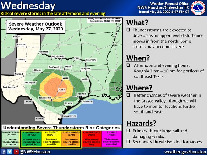
Cpv17 wrote:Yeah I’m liking the setup for tomorrow afternoon and it even looks like I could get some good storms tomorrow evening down here in SETX. Could be a significant tornado threat for CTX.


Yeah, if that persistent line backbuilding near Galveston Bay doesn't keep going and ruin our inflow.

Re: Texas Spring 2020

Posted: Wed May 27, 2020 8:02 am
by TeamPlayersBlue
Long range, the models keep showing a Central American Gyre in the GOM. Those things are great rain makers but frustrating to forecast. Really happy we have been getting solid rains this month.

Re: Texas Spring 2020

Posted: Wed May 27, 2020 8:37 am
by newtotex


And on the 23rd anniversary of the Jarrell tornado

Re: Texas Spring 2020

Posted: Wed May 27, 2020 11:07 am
by TeamPlayersBlue
We have a high level of CAPE and Omega in SE Tx today. Wouldnt put small hail out of the forecast today

Re: Texas Spring 2020

Posted: Wed May 27, 2020 3:16 pm
by 1900hurricane

Re: Texas Spring 2020

Posted: Wed May 27, 2020 3:44 pm
by wxman22
Very potent supercell heading towards the Houston metro area please stay weather aware.

Re: Texas Spring 2020

Posted: Wed May 27, 2020 8:19 pm
by Brent
May have to watch the Gulf next week for possible mischief
Image

Re: Texas Spring 2020

Posted: Wed May 27, 2020 8:37 pm
by weatherdude1108
Got a Spring time thunderstorm this evening, complete with gusty winds and lightning/thunder. Half inch out of it.

Re: Texas Spring 2020

Posted: Wed May 27, 2020 8:46 pm
by bubba hotep
Brent wrote:May have to watch the Gulf next week for possible mischief
https://i.ibb.co/hYwdNHt/L32twSJ.png


The yearly CAG watch! Lopsided storm into the FL panhandle? I would prefer that a system get trapped under a ridge and pushed back into Texas bringing us at least one more round of widespread rain before the summer pattern sets in. I wonder how much the CAG influences the development of the summer pattern across the South? Anytime we get a system in the Central or Eastern Gulf we seem to get a dry pattern locked in across Texas in it's wake. However, that is totally anecdotal and I have not looked at any data.

Re: Texas Spring 2020

Posted: Wed May 27, 2020 8:57 pm
by bubba hotep
newtotex wrote:


And on the 23rd anniversary of the Jarrell tornado


I watched a video of it the other day that I had never seen. It starts as an unimpressive rope and slowly builds into the Monster. Those that know way more than me say it was a unique setup with extreme CAPE and very localized mesoscale features driving things in an otherwise unimpressive larger scale environment. Here is a sounding:

Image

Re: Texas Spring 2020

Posted: Wed May 27, 2020 9:41 pm
by Brent
bubba hotep wrote:
Brent wrote:May have to watch the Gulf next week for possible mischief
https://i.ibb.co/hYwdNHt/L32twSJ.png


The yearly CAG watch! Lopsided storm into the FL panhandle? I would prefer that a system get trapped under a ridge and pushed back into Texas bringing us at least one more round of widespread rain before the summer pattern sets in. I wonder how much the CAG influences the development of the summer pattern across the South? Anytime we get a system in the Central or Eastern Gulf we seem to get a dry pattern locked in across Texas in it's wake. However, that is totally anecdotal and I have not looked at any data.


Yeah I'm wondering about a possible track I mean we had this weakness this week but it's clearing out faster than expected and so far next week is looking more summer like so I dunno

Re: Texas Spring 2020

Posted: Wed May 27, 2020 10:37 pm
by weatherdude1108
My parents and brother in San Antonio on the north side had quarter to golf ball hail earlier. My brother sent a video of it hitting windows. My dad said "I'll bet some dual pane windows got unsealed. My brother said "We had some serious wind" Rough night down there!

Re: Texas Spring 2020

Posted: Thu May 28, 2020 11:28 am
by weatherdude1108
My dad 1.75" out of that supercell in SA last night. Hopefully they won't have to deal with hail a second day a row. May as well be in West Texas!lol Nice little last paragraph the end of the 9am discussion by EWX. Although we don't want the calm to last too long going into Summer, rain is good.
;)

000
FXUS64 KEWX 281400
AFDEWX

Area Forecast Discussion
National Weather Service Austin/San Antonio TX
900 AM CDT Thu May 28 2020

.UPDATE...
Morning update to expand PoPs further to the south and east for this
afternoon. The Storm Prediction Center added much of the I-10
corridor from Kerrville to San Antonio/New Braunfels to Cuero to the
slight risk for today. Mesoscale models do show isolated to scattered
showers and thunderstorms beginning across the Edwards Plateau
between 2pm-4pm and then spreading to the south and east through the
evening and early overnight hours. Some of these storms could be
strong to severe with large hail and damaging winds once again being
the main hazards. Even with the atmosphere being worked over after
yesterday`s storms there should be enough moisture return to produce
decent moisture and instability across the western 2/3rds of the
County Warning Area. Steep mid-level lapse rates will once again aid
in the hail development.
There will be modest shear, but low level
winds should not be conducive to tornado development keeping the
focus on the hail and wind threats.

The afternoon package will dig into the details a bit more, but the
good news is that after today the pesky upper low finally looks to
move off to the east with high pressure settling into South Central
Texas resulting in calmer weather. After an active weather pattern
for the last few weeks I think we can all be thankful for a breather
from the severe weather threat
.

Re: Texas Spring 2020

Posted: Thu May 28, 2020 12:16 pm
by Brent
I know it's 384 hours out but the 6z GFS was epic it's moving towards Texas here :lol:

Image

Re: Texas Spring 2020

Posted: Thu May 28, 2020 12:26 pm
by DonWrk
Brent wrote:
bubba hotep wrote:From the FWD AFD:

By Sunday, nearly continuous troughing will connect a mid-latitude
longwave emerging from the Rockies to a relative weakness in the
Gulf. This will result in a steady transition to a tropical,
moist-adiabatic profile above North and Central Texas. While this
will reduce the severe potential, persistent lift will maintain
widespread showers and embedded thunderstorms throughout Sunday
and Monday. Extraordinary precipitation efficiency through this
protracted rain event could mean considerable flooding by Memorial
Day, both short-scale flashing flooding and more prolonged
flooding of our near-capacity river/reservoir systems.


this was amazing too

The rainfall will further strengthen the troughing aloft, which
will in turn lead to more rain events. This feedback loop will
steadily develop a semi-permanent cyclone over the Lone Star
State. A blocking high over the eastern seaboard will keep the
low anchored, additional rain events only reinforcing its gloom.
It`s often a tall task for largely sub-synoptic processes to
disrupt the background pattern to this extent, but extended
guidance remains in remarkably good agreement. Warm season
patterns like this typically demonstrate considerable ensemble
spread, but that is also not the case. A prolonged heavy rain
event this time of year tends to prevent the development of
subtropical ridging; as a result, a wet pattern is projected to
dominate through the summer solstice.


This statement made me believe we were about to be in for it. Now I feel like the summer pattern is already here, with models showing very little rain for the next 2-3 weeks.

Re: Texas Spring 2020

Posted: Thu May 28, 2020 1:07 pm
by Cpv17
DonWrk wrote:
Brent wrote:
bubba hotep wrote:From the FWD AFD:

By Sunday, nearly continuous troughing will connect a mid-latitude
longwave emerging from the Rockies to a relative weakness in the
Gulf. This will result in a steady transition to a tropical,
moist-adiabatic profile above North and Central Texas. While this
will reduce the severe potential, persistent lift will maintain
widespread showers and embedded thunderstorms throughout Sunday
and Monday. Extraordinary precipitation efficiency through this
protracted rain event could mean considerable flooding by Memorial
Day, both short-scale flashing flooding and more prolonged
flooding of our near-capacity river/reservoir systems.


this was amazing too

The rainfall will further strengthen the troughing aloft, which
will in turn lead to more rain events. This feedback loop will
steadily develop a semi-permanent cyclone over the Lone Star
State. A blocking high over the eastern seaboard will keep the
low anchored, additional rain events only reinforcing its gloom.
It`s often a tall task for largely sub-synoptic processes to
disrupt the background pattern to this extent, but extended
guidance remains in remarkably good agreement. Warm season
patterns like this typically demonstrate considerable ensemble
spread, but that is also not the case. A prolonged heavy rain
event this time of year tends to prevent the development of
subtropical ridging; as a result, a wet pattern is projected to
dominate through the summer solstice.


This statement made me believe we were about to be in for it. Now I feel like the summer pattern is already here, with models showing very little rain for the next 2-3 weeks.


Unless we get that epac crossover.

Re: Texas Spring 2020

Posted: Thu May 28, 2020 1:18 pm
by Brent
Cpv17 wrote:
DonWrk wrote:
Brent wrote:
this was amazing too

The rainfall will further strengthen the troughing aloft, which
will in turn lead to more rain events. This feedback loop will
steadily develop a semi-permanent cyclone over the Lone Star
State. A blocking high over the eastern seaboard will keep the
low anchored, additional rain events only reinforcing its gloom.
It`s often a tall task for largely sub-synoptic processes to
disrupt the background pattern to this extent, but extended
guidance remains in remarkably good agreement. Warm season
patterns like this typically demonstrate considerable ensemble
spread, but that is also not the case. A prolonged heavy rain
event this time of year tends to prevent the development of
subtropical ridging; as a result, a wet pattern is projected to
dominate through the summer solstice.


This statement made me believe we were about to be in for it. Now I feel like the summer pattern is already here, with models showing very little rain for the next 2-3 weeks.


Unless we get that epac crossover.


Yeah the pattern sure did flip fast I remember when it was gonna rain all week

Re: Texas Spring 2020

Posted: Thu May 28, 2020 2:35 pm
by TeamPlayersBlue
Concerning for us in Texas. Position of a 5H in the Ohio Valley area will bring any storm in our direction. Def need to watch this.