Page 5 of 50
Re: Texas Spring 2020
Posted: Wed Mar 18, 2020 9:49 pm
by Texas Snowman
Possible big wedge being reported (via Twitter)
————
@NWSFortWorth — At 941 PM CDT. Confirmed tornado in Chico moving northeast toward Alvord. Residents of Alvord should seek shelter immediately.
Re: Texas Spring 2020
Posted: Wed Mar 18, 2020 9:54 pm
by Texas Snowman
@TxStormChaser — 9:48PM - A confirmed tornado is moving in the Alvord area (Wise County) - residents should already be in their tornado safe space! If not, go now. #txwx #ntxwx
Re: Texas Spring 2020
Posted: Wed Mar 18, 2020 10:27 pm
by Texas Snowman
@TxStormChaser — 10:22PM - A new Tornado Warning has been issued for the storm in Jack County. Rotation and possible tornado about 9 miles southwest of Jacksboro moving northeast. Residents in Jacksboro need to seek shelter. #txwx #ntxwx
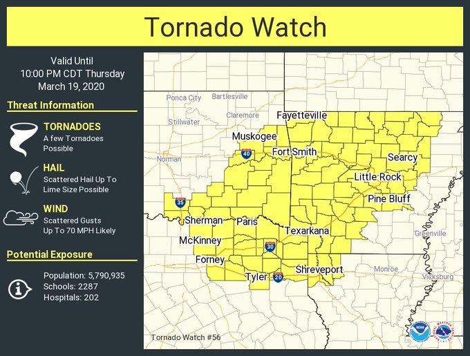
Re: Texas Spring 2020
Posted: Thu Mar 19, 2020 12:04 am
by Texas Snowman
129
WFUS54 KSJT 190454
TORSJT
TXC081-431-190545-
/O.NEW.KSJT.TO.W.0005.200319T0454Z-200319T0545Z/
BULLETIN - EAS ACTIVATION REQUESTED
Tornado Warning
National Weather Service San Angelo TX
1154 PM CDT Wed Mar 18 2020
The National Weather Service in San Angelo has issued a
* Tornado Warning for...
Northwestern Coke County in west central Texas...
East central Sterling County in west central Texas...
* Until 1245 AM CDT.
* At 1153 PM CDT, a large and extremely dangerous tornado was located
near Sterling City, moving northeast at 45 mph.
This is a PARTICULARLY DANGEROUS SITUATION. TAKE COVER NOW!
HAZARD...Damaging tornado.
SOURCE...Radar indicated rotation.
IMPACT...You are in a life-threatening situation. Flying debris
may be deadly to those caught without shelter. Mobile
homes will be destroyed. Considerable damage to homes,
businesses, and vehicles is likely and complete
destruction is possible.
* The tornado will be near...
Silver around 1220 AM CDT.
Sanco around 1230 AM CDT.
Other locations impacted by this tornadic thunderstorm include The
Intersection Of Highway 158 And Ranch Road 2059.
PRECAUTIONARY/PREPAREDNESS ACTIONS...
To repeat, a large, extremely dangerous and potentially deadly
tornado is developing. To protect your life, TAKE COVER NOW! Move to
a basement or an interior room on the lowest floor of a sturdy
building. Avoid windows. If you are outdoors, in a mobile home, or in
a vehicle, move to the closest substantial shelter and protect
yourself from flying debris.
Tornadoes are extremely difficult to see and confirm at night. Do not
wait to see or hear the tornado. TAKE COVER NOW!
&&
LAT...LON 3187 10105 3209 10076 3208 10067 3208 10055
3194 10050 3181 10101
TIME...MOT...LOC 0453Z 234DEG 38KT 3188 10096
TORNADO...RADAR INDICATED
TORNADO DAMAGE THREAT...CONSIDERABLE
HAIL...1.00IN
$$
Re: Texas Spring 2020
Posted: Thu Mar 19, 2020 12:33 pm
by bubba hotep
Significant SW expansion of the Slight to cover DFW

For reference, the earlier outlook

Re: Texas Spring 2020
Posted: Thu Mar 19, 2020 4:37 pm
by bubba hotep
NE Burbs under the Gun
Re: Texas Spring 2020
Posted: Fri Mar 20, 2020 2:17 pm
by Haris
Man it’s quiet here... .92” of rain this Fri morning here W of Austin . Hoping for another inch on Sat!
Re: Texas Spring 2020
Posted: Fri Mar 20, 2020 5:56 pm
by Rgv20
Tidbit from the NWS Brownsville discussion....Could see the first 100+ temperature of the season for McAllen/Edinburg area
Temperature profiles still trending
well above normal daytime anomalies reach a whopping 12-18+ degrees
and minimums 8-12 above mid-March normals. GFS and ECMWF peaking
850mb temps at 25-27.5C Wed/Thu which should push several locations
over the century mark.
Re: Texas Spring 2020
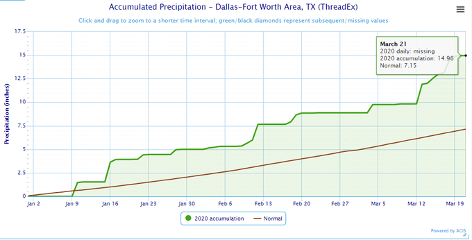
Posted: Sat Mar 21, 2020 4:13 pm
by Cpv17
I’m finally getting some good rain down here!!
Re: Texas Spring 2020
Posted: Sat Mar 21, 2020 7:02 pm
by bubba hotep
Another rainy night on tap for DFW

Re: Texas Spring 2020
Posted: Sat Mar 21, 2020 7:07 pm
by bubba hotep
2020 the wettest start to date for DFW! Go Rain!
Re: Texas Spring 2020
Posted: Sun Mar 22, 2020 7:45 pm
by bubba hotep
Looks like DFW will get 4 or 5 days to dry out before an active pattern returns starting this weekend.
Re: Texas Spring 2020
Posted: Mon Mar 23, 2020 5:30 pm
by Brent
Sighs I miss this thread being busy even if it was a complaint thread

Re: Texas Spring 2020
Posted: Mon Mar 23, 2020 11:23 pm
by Cerlin
It’s going to be finally nice to see some sun. I’ve never seen my area so swampy to start the spring. It’s a shame we never got the cold rolling like we could have or else it could still be a winter wonderland now. Oh well!
Re: Texas Spring 2020
Posted: Tue Mar 24, 2020 7:36 am
by gpsnowman
Cerlin wrote:It’s going to be finally nice to see some sun. I’ve never seen my area so swampy to start the spring. It’s a shame we never got the cold rolling like we could have or else it could still be a winter wonderland now. Oh well!
Seriously. March has been quite cloudy this year. Got back from Caddo Lake yesterday and it was wet the entire time I was there. I thought I was in the Dagobah system. Enjoy the sun!!!
Re: Texas Spring 2020
Posted: Tue Mar 24, 2020 11:03 am
by bubba hotep
Next week looks pretty amazing for N. Texas with highs in the upper 60's but maybe some storms on Tuesday. Just have to get through this heat wave of 80s over the next few days.
Re: Texas Spring 2020
Posted: Tue Mar 24, 2020 11:42 am
by vbhoutex
This is this morning's email from Jeff Lindner specific to SE TX. Nice to see some sun after a really cloudy beginning, but I could do without the heat this early.
Here at my home in W. Houston we have had only 5.54" of rain since Jan 1.
I
It is a bit early this year…but high temperatures near 90 are possible Wednesday and Thursday with heat index values in the lower to mid 90’s.
An upper level ridge of high pressure over MX and the Gulf of Mexico will build northward into TX this week before moving eastward toward Cuba by this weekend. The result will be surface temperatures rising into the mid 80’s today and near 90 both Wednesday and Thursday. Southerly winds will continue to bring Gulf moisture and dewpoints in the upper 60’s into the area and this will result in heat index values in the low to mid 90’s.
A cold front will move across the area on Saturday as the upper level ridge becomes centered over the SE Gulf of Mexico. This front will lower temperatures into the 70’s for highs and the 50’s for lows. Rain chances look meager with the front, but may increase late in the weekend into early next week as a coastal trough forms over the western Gulf.
Jeff Lindner
Re: Texas Spring 2020
Posted: Tue Mar 24, 2020 8:58 pm
by TropicalTundra
Reached 90F today! Now that’s a summer start.

Re: Texas Spring 2020
Posted: Wed Mar 25, 2020 10:46 am
by bubba hotep
00z Euro looks like a reprint of runs from a couple of weeks ago


Re: Texas Spring 2020
Posted: Wed Mar 25, 2020 1:46 pm
by captainbarbossa19
I am happy to read that many here are receiving plentiful amounts of rain. Meanwhile where I live, it continues to get drier every day. I have had less than one inch of rain since March 1st. Every storm system that moves through the majority of the state has been skipping my area. I hope that things will change soon. However, March is normally a drier month for my region so I am hopeful for April.
