Texas Winter 2023-2024
Moderator: S2k Moderators
Forum rules
 The posts in this forum are NOT official forecast and should not be used as such. They are just the opinion of the poster and may or may not be backed by sound meteorological data. They are NOT endorsed by any professional institution or STORM2K.

The posts in this forum are NOT official forecast and should not be used as such. They are just the opinion of the poster and may or may not be backed by sound meteorological data. They are NOT endorsed by any professional institution or STORM2K.
-
Stratton23
- Category 2

- Posts: 562
- Joined: Fri Jul 21, 2023 10:59 pm
- Location: College Station, Tx
Re: Texas Winter 2023-2024
First half of december looks to be mild, i dont see cold weather returning until probably the 3rd week of december, EPO does look to tank, AO goes negative as well, i guess we will see if we get any big cold snap or not
0 likes
-
Stratton23
- Category 2
- Posts: 562
- Joined: Fri Jul 21, 2023 10:59 pm
- Location: College Station, Tx
Re: Texas Winter 2023-2024
Seeing some big changes in the 500 mb level in all global guidance, time frame to watch is the 10th-15th
0 likes
-
tajmahal
- Tropical Storm

- Posts: 168
- Age: 66
- Joined: Tue Jan 10, 2012 10:09 am
- Location: Austin, TX area & eastern Africa
Re: Texas Winter 2023-2024
The GFS endsemble mean is showing that the 500 mb high over the Aleutians during mid–December will be undercut by fast flow and shoved into the Arctic without causing downstream long wave troughing.
0 likes
-
Stratton23
- Category 2
- Posts: 562
- Joined: Fri Jul 21, 2023 10:59 pm
- Location: College Station, Tx
Re: Texas Winter 2023-2024
Significant trough digging really far south into the desert SW at day 10 on the euro, gets trapped under ridging
2 likes
Re: Texas Winter 2023-2024
Stratton23 wrote:Significant trough digging really far south into the desert SW at day 10 on the euro, gets trapped under ridging
Yeah, that looks interesting.
0 likes
-
Iceresistance

- Category 5

- Posts: 8916
- Age: 20
- Joined: Sat Oct 10, 2020 9:45 am
- Location: Tecumseh, OK/Norman, OK
Re: Texas Winter 2023-2024
This is the image of that trough if y'all want to see what it looks like, I have never seen one that deep from the Euro
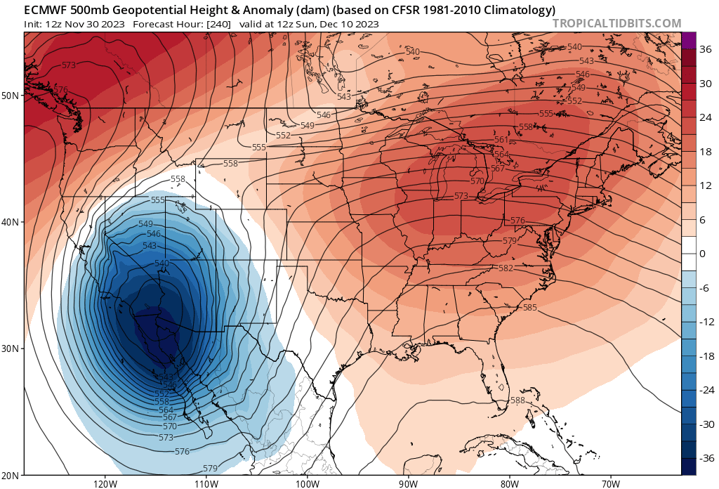
https://s5.gifyu.com/images/SROv3.png
https://s5.gifyu.com/images/SROv3.png
3 likes
Bill 2015 & Beta 2020
Winter 2020-2021
All observations are in Tecumseh, OK unless otherwise noted.
Winter posts are focused mainly for Oklahoma & Texas.
Take any of my forecasts with a grain of salt, refer to the NWS, SPC, and NHC for official information
Never say Never with weather! Because ANYTHING is possible!
Winter 2020-2021
All observations are in Tecumseh, OK unless otherwise noted.
Winter posts are focused mainly for Oklahoma & Texas.
Take any of my forecasts with a grain of salt, refer to the NWS, SPC, and NHC for official information
Never say Never with weather! Because ANYTHING is possible!
-
tajmahal
- Tropical Storm
- Posts: 168
- Age: 66
- Joined: Tue Jan 10, 2012 10:09 am
- Location: Austin, TX area & eastern Africa
Re: Texas Winter 2023-2024
Excerpts from Dr. Judah Cohen's blog on Monday of this week about his expectations for December's weather and the winter as a whole (most who want Arctic outbreaks would enjoy this read):
And then, here is his Wednesday update of his blog on Monday:
https://www.aer.com/science-research/climate-weather/arctic-oscillation/
A stretching of the polar vortex (PV) like a rubber band being pulled on both ends is bringing colder and snowier weather to East Asia but even more so to eastern North America this week. Separately, high pressure in the North Atlantic and eventually Greenland will bring colder and even snowier weather to Europe this week and early December.
A larger PV disruption will deepen the cold in Europe but bring milder weather to much of North America. At that point we will probably reach the most important crossroad of the winter going down a milder or a colder path.
* * * *
Impacts
We currently have a stretched PV for this week bringing colder temperatures for much of the US and even above normal snow cover to the US after being well below normal last week. Meanwhile, high pressure ridging in the northern North Atlantic and spreading west towards Greenland is forcing deep low pressure troughing across Europe allowing cold temperature previously limited to Scandinavia to spread across much of Europe. I thought that it is interesting that the low pressure bringing cold and snow to Europe is directly coupled to the stratospheric PV center....
* * * *
The deep troughing in Europe is also supporting the advancing snow cover in the region that erased an impressive deficit in snow cover across western Eurasia. And looking at NH snow cover extent this fall, the advance comes in stalls and spikes. This stepwise increase in snow cover extent seems to me a bit unusual and seems to coincide with PV disruption (rapid increase) followed by a strengthening PV (long stall).
* * * *
The stretched PV is predicted to be followed by a Canadian warming.... And I must say the surface temperature anomaly plot included with the Canadian warming is looking pretty good as a first guess with the predicted surface temperature anomalies for the first week or two of December. In general, the pattern is a tripole of sorts, warm for North America (especially Canada), cold for northern Eurasia and warm for southern Eurasia....
But I don’t expect the Canadian warming to last very long, or the surface temperature pattern associated with it. The latest ECMWF weeklies are predicting a perpetual Canadian warming, but I am highly skeptical. So, the obvious question becomes what comes next.... A frequent collaborator of my recent papers, Laurie Agel, computed for a manuscript in preparation ... the transition from Canadian warmings, which I find very interesting. Canadian warmings overwhelmingly transition to just two other PV phases one is a larger sudden stratospheric warming (SSW) but most commonly to a stretched PV. A Canadian warming can transition to other PV states (in the strong PV category), but it is significantly less likely.
Our toy and flawed polar vortex strength forecast model has been performing surprisingly well so far this PV season, correctly predicting peak PV strength for the last week with a weakening trend culminating in a weaker than normal PV second week of December that is now expected to be a Canadian warming or a minor warming of the polar stratosphere. The PV model is predicting a slow strengthening trend of the PV after December 10th but nothing comparable to late November. Also, I don’t feel that a negative AO/NAO is a favorable pattern for significant weakening of the PV. I hope that anyone who reads the blog regularly know that it is my strong opinion that Scandinavian/Ural/Barents-Kara seas blocking or high-pressure ridging is the one atmospheric feature that is most favorable for weakening the PV. Based on these two data points, I feel that a direct transition from the Canadian warming to a more substantial weakening of the PV akin to a SSW is less likely. Therefore, is seems reasonable to me the most likely PV phase or state to follow the Canadian warming early next month is a stretched PV.
If my reasoning is correct, what NH surface temperature pattern should follow this broad strokes tripole pattern? Based on our research and my own observations writing the blog, the larger stretched PV events begin with the core of the cold temperatures in Central and Eastern Asia followed by cold temperatures beginning about a week later in North America mostly east of the Rockies. There isn’t a strong relationship between stretched PVs and European temperatures. But if it does turn much colder in North America, this often fires up the jet stream over the North Atlantic which results in a westerly maritime flow across much of Europe that favors milder temperatures with the possible exception of Scandinavia....
So, what do I expect in the coming weeks as far as temperature anomalies? We have the cold now in the Eastern US and to a lesser extent in Northeast Asia associated with the latest stretched PV. With the upcoming Canadian warming, it looks like the cold will continue to spread across Europe and the coldest temperatures across the NH will become focused in Northern Europe and Western Asia. Concurrently, temperatures should turn milder across eastern North America. From a timing standpoint, this would evolve over the first two weeks of December.
Now if I am correct [that] ... what comes next is a stretched PV, then I would expect the core of the cold to shift from western Eurasia to eastern Eurasia with the deepest cold firmly in Siberia. At this point the populated regions of Northeast Asia are under increasing risk to an Arctic outbreak. It is my experience that with the larger stretched PV events, the cold in Asia is a precursor to cold in North America as happened in February 2021 and December 2022. To be clear, I am not predicting cold of the magnitude of those two events, but I do think that the potential is there for a more intense cold air outbreak than what we have so far observed in the fall of 2023 (and admittedly not a high bar). From a timing standpoint, this would evolve over the second and third weeks of December.
The impact on our weather from stretched PVs is usually in the order of one to two weeks, so as we approach the holidays, we should see yet another transition in the PV and its associated weather. This could be the most important inflection point of the winter of 2023/24. I have discussed this before in the blog, based on my experience, stretched PVs can be a precursor to the larger PV disruptions of the SSW variety, we saw that scenario just last winter.... But on the other hand, the atmospheric structure that favors stretched PVs also blocks or protects the PV from upwelling energy from the troposphere, allowing a runaway strong PV and this is nicely exemplified by December 2019 and the PV in winter 2019/20 was record strong. A strong PV doesn’t preclude stretched PVs and this characterized the winter of 2021/22.
I think that I have been saying this for at least two decades “Siberia is the refrigerator of the Northern Hemisphere.” I would be very skeptical of a cold winter if the dynamical model forecasts that I showed in last week’s blog verify with widespread above normal temperatures especially across Siberia. If it can turn colder for an extended period of time that would favor an SSW over a strong PV. The weather models are predicting high-pressure ridging in the region of the Urals and the Barents-Kara Seas. This also favors an SSW as well as stretched PVs over a strong and circular PV, but I have been burned before by the weather models that have really struggled so far in late fall and early winter. Finally, our PV model is predicting a further weakening of the PV the last week of December but it is just one data point, so confidence is very low. But this should be interesting to follow in the coming days.
All that I wrote is highly speculative even if it may sound like I have it all figured out. But I am trying to apply my research from two decades ago until today to predict the weather beyond the weather models but I hope the limitations are well appreciated.
It is the last few days of November so in blog tradition, I include the NH winter surface temperature anomalies forecast in Figure iii. I include the North American Multi Model Ensemble (NMME) winter forecast (top) and the C3S (a European model ensemble) winter forecast (middle) and the Atmospheric and Environmental Research (AER) winter forecast (bottom).
* * * *
The two dynamical model forecasts, both the American ensemble and the European ensembles, predict almost universal relative warmth especially across Eurasia but also North America with the possible exception of near seasonal in the Southeastern US, which is related to the ongoing El Niño. But the dynamical winter forecasts are almost indistinguishable from other recent winters despite the change in El Niño/Southern Oscillation (ENSO) phase.
The AER model is colder but overall lacks strong anomalies. The predicted weak temperature anomalies are a result of only slightly above normal October Eurasian snow cover extent and below normal October sea ice extent in the Barents-Kara Seas that was relatively higher than most recent years. Also included is El Niño that resulted in stronger anomalies in North America with warm in Alaska, Canada and the Northern US and cold in the south-central US.
And then, here is his Wednesday update of his blog on Monday:
Though what I wrote on Monday was really pushing the envelope of what is possible in long range forecasting, I am encouraged by what I see. I discussed that the most likely transition for the polar stratosphere from the Canadian warming is a stretched PV. Still no definite signs of that yet on the weather models, but I think the models are trending in that direction. Our wave prognostics are still only suggestive of a stretched PV, but are trending in the right direction. But the two strongest signs that I see of an eventual stretched PV in the lead up to the holiday season are strong Greenland blocking and the recent weather model forecast of cold air pooling in Alaska and Northwestern Canada.
A pattern of Greenland blocking or probably more accurately northern North Atlantic blocking (high pressure ridging stretching from Greenland to Scandinavia and even into the Barents-Kara Seas) with low pressure troughing across Europe is a precursor to stretched PV events with about a two-week lead. ... The second precursor is the building or pooling of surface cold air in Alaska and Northwest Canada predicted by the weather models. It is my experience this is often a precursor of an Arctic outbreak to the lower 48 associated with stretched PV events. We observed this both in February 2021 and December 2022. With my handwaving arguments, I cannot predict the magnitude of a cold air outbreak 3-4 weeks from now but there is potential for it to be impactful.
https://www.aer.com/science-research/climate-weather/arctic-oscillation/
2 likes
-
tajmahal
- Tropical Storm
- Posts: 168
- Age: 66
- Joined: Tue Jan 10, 2012 10:09 am
- Location: Austin, TX area & eastern Africa
Re: Texas Winter 2023-2024
"No detectable trend in mid-latitude cold extremes during the recent period of Arctic amplification," Dr. Judah Cohen, October 2023.
https://www.aer.com/news-events/blog/no-detectable-trend-in-mid-latitude-cold-extremes-during-the-recent-period-of-arctic-amplification/
https://www.aer.com/news-events/blog/no-detectable-trend-in-mid-latitude-cold-extremes-during-the-recent-period-of-arctic-amplification/
0 likes
Re: Texas Winter 2023-2024
Iceresistance wrote:This is the image of that trough if y'all want to see what it looks like, I have never seen one that deep from the Euro
https://s5.gifyu.com/images/SROv3.png
https://s5.gifyu.com/images/SROv3.png
I’ve probably seen one that deep on the Euro before but definitely not in that area.
0 likes
-
Stratton23
- Category 2
- Posts: 562
- Joined: Fri Jul 21, 2023 10:59 pm
- Location: College Station, Tx
Re: Texas Winter 2023-2024
That would be a pretty darn good setup for a winter storm, especially with a trough that strong, will be interesting to see how this evolves down the road
0 likes
-
Iceresistance
- Category 5
- Posts: 8916
- Age: 20
- Joined: Sat Oct 10, 2020 9:45 am
- Location: Tecumseh, OK/Norman, OK
Re: Texas Winter 2023-2024
EPS has a huge cold airmass moving towards Eastern Siberia by Mid-December

https://s5.gifyu.com/images/SROqF.gif
Entire Run
https://s5.gifyu.com/images/SROqF.gif
Entire Run
0 likes
Bill 2015 & Beta 2020
Winter 2020-2021
All observations are in Tecumseh, OK unless otherwise noted.
Winter posts are focused mainly for Oklahoma & Texas.
Take any of my forecasts with a grain of salt, refer to the NWS, SPC, and NHC for official information
Never say Never with weather! Because ANYTHING is possible!
Winter 2020-2021
All observations are in Tecumseh, OK unless otherwise noted.
Winter posts are focused mainly for Oklahoma & Texas.
Take any of my forecasts with a grain of salt, refer to the NWS, SPC, and NHC for official information
Never say Never with weather! Because ANYTHING is possible!

Re: Texas Winter 2023-2024
I like Cohen but his theories have never held up to scrutiny. To his credit he admits it. I agree with him on the point that the PV is not going to be a strong one this winter.
3 likes
-
tajmahal
- Tropical Storm
- Posts: 168
- Age: 66
- Joined: Tue Jan 10, 2012 10:09 am
- Location: Austin, TX area & eastern Africa
Re: Texas Winter 2023-2024
Quixotic wrote:I like Cohen but his theories have never held up to scrutiny. To his credit he admits it. I agree with him on the point that the PV is not going to be a strong one this winter.
His theories have held up to scrutiny. There are scientists who agree and disagree with him, of course. But if he were a flake, he would not be publishing regularly in our most prestigious science journals:
Science
Nature
Nature Climate
Journal of the American Meteorological Society
Journal of Geophysical Research: Atmospheres
Environmental Research
Climate and Atmospheric Science
Etc
And his articles, according to Google Scholar, have been cited thousands of times by other scientists in their own journal articles. That is how scientists are evaluated by their peers.
0 likes
-
ThunderSleetDreams

- S2K Supporter

- Posts: 1398
- Age: 41
- Joined: Tue Dec 20, 2011 4:42 pm
- Location: S of Weimar, TX
Re: Texas Winter 2023-2024
Quixotic wrote:I like Cohen but his theories have never held up to scrutiny. To his credit he admits it. I agree with him on the point that the PV is not going to be a strong one this winter.
It would make sense that the PV wouldn’t be strong this Winter. I think most would agree with that.
0 likes
#NeverSummer
I hibernate when it gets above 75 degrees!
I hibernate when it gets above 75 degrees!
Re: Texas Winter 2023-2024
tajmahal wrote:Quixotic wrote:I like Cohen but his theories have never held up to scrutiny. To his credit he admits it. I agree with him on the point that the PV is not going to be a strong one this winter.
His theories have held up to scrutiny. There are scientists who agree and disagree with him, of course. But if he were a flake, he would not be publishing regularly in our most prestigious science journals:
Science
Nature
Nature Climate
Journal of the American Meteorological Society
Journal of Geophysical Research: Atmospheres
Environmental Research
Climate and Atmospheric Science
Etc
And his articles, according to Google Scholar, have been cited thousands of times by other scientists in their own journal articles. That is how scientists are evaluated by their peers.
But isn’t his big baby the strength of the PV is directly correlated to SAI during October, November and Fall?
0 likes
Re: Texas Winter 2023-2024
Surprisingly the GFS and Euro are both in decent agreement about the placement of the day 10 trough out west.
1 likes
-
Stratton23
- Category 2
- Posts: 562
- Joined: Fri Jul 21, 2023 10:59 pm
- Location: College Station, Tx
-
bubba hotep

- S2K Supporter
- Posts: 5514
- Joined: Wed Dec 28, 2016 1:00 am
- Location: Collin County Texas
Re: Texas Winter 2023-2024
Might have to book a trip out to New Mexico or CO!

1 likes
Winter time post are almost exclusively focused on the DFW area.
-
WacoWx
- Category 2
- Posts: 582
- Joined: Mon Dec 28, 2009 4:14 pm
- Location: NOT Waco, TX ----> Dallas, TX
Re: Texas Winter 2023-2024
That would really bode well for the family ski trip to Red River after xmas. Crossing my fingers!
1 likes
-
bubba hotep
- S2K Supporter
- Posts: 5514
- Joined: Wed Dec 28, 2016 1:00 am
- Location: Collin County Texas
Re: Texas Winter 2023-2024
Pretty strong agreement across the models on a dynamic system impacting the state out beyond Day 7. Classic El Nino Bowling Ball on tap!


4 likes
Winter time post are almost exclusively focused on the DFW area.
Who is online
Users browsing this forum: Google [Bot] and 153 guests