Texas Winter 2017-2018
Moderator: S2k Moderators
Forum rules
 The posts in this forum are NOT official forecast and should not be used as such. They are just the opinion of the poster and may or may not be backed by sound meteorological data. They are NOT endorsed by any professional institution or STORM2K.

The posts in this forum are NOT official forecast and should not be used as such. They are just the opinion of the poster and may or may not be backed by sound meteorological data. They are NOT endorsed by any professional institution or STORM2K.
-
1900hurricane

- Category 5

- Posts: 6044
- Age: 33
- Joined: Fri Feb 06, 2015 12:04 pm
- Location: Houston, TX
- Contact:
Re: Texas Winter 2017-2018
Only 34 more minutes until 00Z March 1st!
1 likes
Contract Meteorologist. TAMU & MSST. Fiercely authentic, one of a kind. We are all given free will, so choose a life meant to be lived. We are the Masters of our own Stories.
Opinions expressed are mine alone.
Follow me on Twitter at @1900hurricane : Read blogs at https://1900hurricane.wordpress.com/
Opinions expressed are mine alone.
Follow me on Twitter at @1900hurricane : Read blogs at https://1900hurricane.wordpress.com/

Re: Texas Winter 2017-2018
Texas Snowman wrote:wxman57 wrote:CaptinCrunch wrote:As we close out the Winter thread today I would like to thank everyone for your insight and objected views of this winter. It's what makes this community so much fun to be a part of and I truly appreciate being a part of such a awesome group of people.
Chalk another Winter outlook success up to the "Halloween Anology" this La Nina was cooler/wetter for much of Texas this year, which sure as hell beats what we had the last 2 winters...
Oh, and let's give props when do, wxman57 came through on his promiss for most!! However
You're welcome about the snow and cold this winter, but next winter is MINE!
Puhleeze! Winter doesn’t belong to you, never has, never will. After years of making some here believe that you were behind the Wizard’s curtain controlling the buttons and dials, we finally saw through the charade this year.
You’re like the Abominable Snowman in “Rudolph the Red Nosed Reindeer”...without teeth!!!
In other words, “we aren’t scared!”


More like a baby's diaper than the Abominable Snowman!


0 likes
-
bubba hotep

- S2K Supporter

- Posts: 5527
- Joined: Wed Dec 28, 2016 1:00 am
- Location: Collin County Texas
Re: Texas Winter 2017-2018
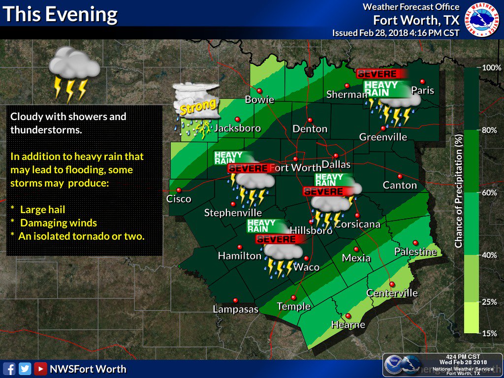
Watch extended westward across DFW:

0 likes
Winter time post are almost exclusively focused on the DFW area.
-
bubba hotep
- S2K Supporter
- Posts: 5527
- Joined: Wed Dec 28, 2016 1:00 am
- Location: Collin County Texas
Re: Texas Winter 2017-2018
This is a pretty slow moving line of storms, hopefully it gets everything out over the airport before midnight to break the record.

0 likes
Winter time post are almost exclusively focused on the DFW area.
-
Texas Snowman

- Storm2k Moderator

- Posts: 6041
- Joined: Fri Jan 25, 2008 11:29 am
- Location: Denison, Texas
Re: Texas Winter 2017-2018
Water flowing everywhere in the streets right now here in Denison.
February 2018 kind of resembles May and June 2015.
Without the ice storm last week and the corresnding power outages, of course.
February 2018 kind of resembles May and June 2015.
Without the ice storm last week and the corresnding power outages, of course.
3 likes
The above post and any post by Texas Snowman is NOT an official forecast and should not be used as such. It is just the opinion of the poster and may or may not be backed by sound meteorological data. It is NOT endorsed by any professional institution including storm2k.org. For official information, please refer to NWS products.
Re: Texas Winter 2017-2018
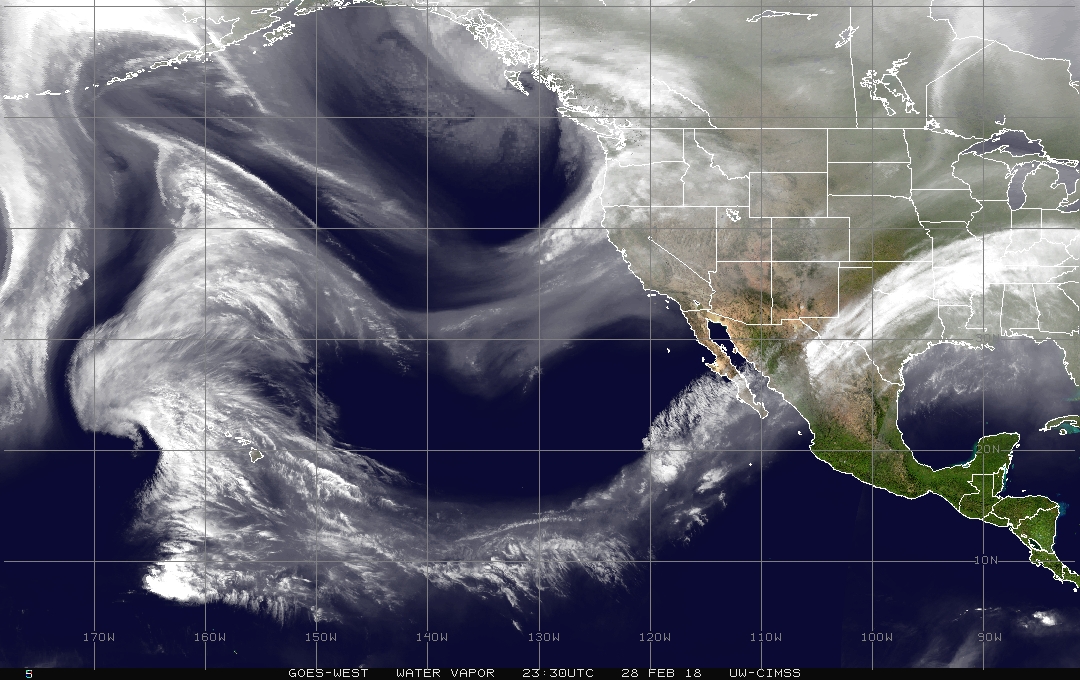
Can never get enough of this. Something about EPAC tropics + western trough is always magic in Texas!
I hope we get this set up again in April and May boy would that be fun
I hope we get this set up again in April and May boy would that be fun
3 likes
The above post and any post by Ntxw is NOT an official forecast and should not be used as such. It is just the opinion of the poster and may or may not be backed by sound meteorological data. It is NOT endorsed by any professional institution including Storm2k. For official information, please refer to NWS products.
Help support Storm2K!
-
bubba hotep
- S2K Supporter
- Posts: 5527
- Joined: Wed Dec 28, 2016 1:00 am
- Location: Collin County Texas
Re: Texas Winter 2017-2018
Euro EPS is carving out another big western trough in the longer range.
1 likes
Winter time post are almost exclusively focused on the DFW area.
-
Brent
- S2K Supporter
- Posts: 37124
- Age: 35
- Joined: Sun May 16, 2004 10:30 pm
- Location: Tulsa Oklahoma
- Contact:
Re: Texas Winter 2017-2018
that line needs to get moving then stall over the airport 
0 likes
#neversummer
-
South Texas Storms

- Professional-Met

- Posts: 4018
- Joined: Thu Jun 24, 2010 12:28 am
- Location: Houston, TX
Re: Texas Winter 2017-2018
bubba hotep wrote:Euro EPS is carving out another big western trough in the longer range.
Hope it digs a little deeper next time. South and central TX has missed out on the heaviest rain so far this year. Currently have rainfall totals near normal.
3 likes


Re: Texas Winter 2017-2018
Must break record! History must be ours tonight! February 2018 most rainiest rainy February ever in DFW (hopefully).
1 likes
-
bubba hotep
- S2K Supporter
- Posts: 5527
- Joined: Wed Dec 28, 2016 1:00 am
- Location: Collin County Texas
Re: Texas Winter 2017-2018
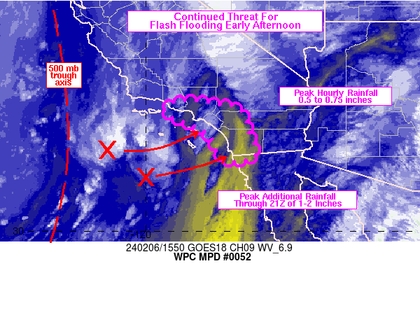
MESOSCALE PRECIPITATION DISCUSSION 0052
NWS WEATHER PREDICTION CENTER COLLEGE PARK MD
725 PM EST WED FEB 28 2018
AREAS AFFECTED...NORTHEAST TX...SOUTHERN AR...NORTHERN
MS...SOUTHWEST TN...NORTHWEST AL
CONCERNING...HEAVY RAINFALL...FLASH FLOODING LIKELY
VALID 010030Z - 010500Z
SUMMARY...CONVECTION TRAINING OVER AREAS WITH SATURATED SOILS IS
EXPECTED TO PRODUCE FLASH FLOODING INTO THE LATE EVENING HOURS.
DISCUSSION...REGIONAL RADARS SHOWED AXES OF LOW TOPPED CONVECTION
FORMING AND MOVING IN A BROAD WARM AIR ADVECTION PATTERN AHEAD OF
A SHORT WAVE OVER THE SOUTHWEST STATES. THE BEST CONVECTION
EXTENDED FROM NORTHEAST TX INTO SOUTHERN AR AND NORTHERN
MS...CLOSEST TO THE BEST INSTABILITY (WHICH FORMED DURING
DIFFERENTIAL HEATING DURING THE AFTERNOON HOURS). THE MOST RECENT
GOES-16 CLEAN IR LOOP SHOWED A LONG FETCH OF MOISTURE STRETCHING
FROM THE EASTERN PACIFIC ACROSS WEST TX INTO THE LOWER MS AND
LOWER TN VALLEYS. WITHIN THIS DEEP MOISTURE PLUME...THE MOST
RECENT RAP ANALYSIS SHOWED 1.75 INCH PRECIPITABLE WATER
VALUES...WHICH ARE ABOUT THREE STANDARD DEVIATIONS ABOVE THE MEAN.
THE AXES OF LOW TOPPED CONVECTION WERE ALIGNED WITH THE 850-300 MB
MEAN FLOW...AND TRAINING WAS OCCURRING WITH THE CONVECTION ON THE
NORTHERN EDGE OF THE INSTABILITY. BASED ON REGIONAL
RADARS...HOURLY RAINFALL RATES RANGED BETWEEN 0.50 AND 1.00
INCHES. HOWEVER...THESE RAINFALL RATES WERE OCCURRING OVER AREAS
WITH SATURATED SOILS...WHERE 5 TO 10 INCHES OF RAINFALL HAS
OCCURRED OVER THE PAST WEEK. SO... DESPITE THE RELATIVELY MODEST
HOURLY RAINFALL RATES...FLASH FLOODING HAS OCCURRED WITH THIS
CONVECTION.
THE LOW LEVEL CONVERGENCE AHEAD OF THE MID LEVEL SHORT WAVE IS
EXPECTED TO REMAIN MORE OR LESS IN THE SAME PLACE THROUGH AT LEAST
01/05Z...EXTENDING FROM NORTHEAST TX INTO SOUTHWEST TN. THE DEEP
MOISTURE IN THE CONVERGENCE ZONE WILL CONTINUE TO FEED LOW TOPPED
CONVECTION...WHERE THE ALIGNMENT OF 850-300 MB MEAN WINDS AND
PROPAGATION VECTORS SUPPORT TRAINING. IT IS POSSIBLE THAT
INSTABILITY EVENTUALLY BECOMES A LIMITING FACTOR FOR THE EXPANSION
OF CONVECTION...ESPECIALLY AFTER 01/04Z OVER PORTIONS OF THE LOWER
MS VALLEY. HOWEVER...
INCREASING MID TO UPPER LEVEL DIVERGENCE AHEAD OF THE SHORT WAVE
PROVIDES SYNOPTIC SCALE ASCENT FOR MORE ORGANIZED CONVECTION TO
FORM.
THERE IS GOOD MULTI HIGH RESOLUTION MODEL SUPPORT FOR AN AXIS OF 2
TO 4 INCHES OF RAINFALL EXTENDING FROM NORTHEAST TX ACROSS CENTRAL
AND SOUTHERN AR INTO NORTHERN MS/NORTHWEST AL/WESTERN TN.
SOME HIGH RESOLUTION MODEL SPREAD EXISTS CONCERNING THE PLACEMENT
OF THE HIGHEST RAINFALL AXIS...WITH THE 12Z NSSL WRF AND 12Z WRF
ARW FURTHER SOUTH THAN THE MOST RECENT HRRR. GIVEN THE PLACEMENT
OF THE BEST INSTABILITY INTO THE LATE EVENING HOURS...A MORE
SOUTHERN PLACEMENT OF THE RAINFALL AXIS IS PREFERRED. THE
ADDITIONAL RAINFALL IS EXPECTED TO RESULT IN ADDITIONAL FLASH
FLOODING...OR AN EXACERBATION OF THE EXISTING FLOODING. GIVEN THE
SATURATED CONDITIONS IN PLACE... DAMAGING AND LIFE-THREATENING
FLASH FLOODING IS POSSIBLE INTO THE LATE EVENING HOURS.
HAYES
0 likes
Winter time post are almost exclusively focused on the DFW area.
Re: Texas Winter 2017-2018
funster wrote:Must break record! History must be ours tonight! February 2018 most rainiest rainy February ever in DFW (hopefully).
We should get enough rain. The question is, can it happen by 11:59pm!
0 likes
The above post and any post by Ntxw is NOT an official forecast and should not be used as such. It is just the opinion of the poster and may or may not be backed by sound meteorological data. It is NOT endorsed by any professional institution including Storm2k. For official information, please refer to NWS products.
Help support Storm2K!
Help support Storm2K!
Re: Texas Winter 2017-2018
Looks like the precip shield is widening. Just need that line to tighten a bit for some heavy stuff.
0 likes
-
bubba hotep
- S2K Supporter
- Posts: 5527
- Joined: Wed Dec 28, 2016 1:00 am
- Location: Collin County Texas

Re: Texas Winter 2017-2018
Ntxw wrote:funster wrote:Must break record! History must be ours tonight! February 2018 most rainiest rainy February ever in DFW (hopefully).
We should get enough rain. The question is, can it happen by 11:59pm!
I hope so. We don't need much. At 6.98 inches as of 4 p.m.
https://forecast.weather.gov/product.ph ... suedby=dfw
0 likes
-
Brent
- S2K Supporter
- Posts: 37124
- Age: 35
- Joined: Sun May 16, 2004 10:30 pm
- Location: Tulsa Oklahoma
- Contact:
Re: Texas Winter 2017-2018
flaring up approaching the airport
No snow but at least were going to set a good record
No snow but at least were going to set a good record
0 likes
#neversummer
-
starsfan65

- Category 2

- Posts: 675
- Age: 46
- Joined: Thu Dec 17, 2015 1:18 pm
- Location: Garland,Tx
Re: Texas Winter 2017-2018
starsfan65 wrote:Why is rain expanding?
The flow ahead of it is igniting more storms in the more juicy air near DFW and northeastward. See bubba's graphic from the SPC.

0 likes
The above post and any post by Ntxw is NOT an official forecast and should not be used as such. It is just the opinion of the poster and may or may not be backed by sound meteorological data. It is NOT endorsed by any professional institution including Storm2k. For official information, please refer to NWS products.
Help support Storm2K!
Help support Storm2K!
-
starsfan65
- Category 2
- Posts: 675
- Age: 46
- Joined: Thu Dec 17, 2015 1:18 pm
- Location: Garland,Tx
Re: Texas Winter 2017-2018
when is the rain going to end?Ntxw wrote:starsfan65 wrote:Why is rain expanding?
The flow ahead of it is igniting more storms in the more juicy air near DFW and northeastward. See bubba's graphic from the SPC.
0 likes
Re: Texas Winter 2017-2018
starsfan65 wrote:when is the rain going to end?Ntxw wrote:starsfan65 wrote:
The flow ahead of it is igniting more storms in the more juicy air near DFW and northeastward. See bubba's graphic from the SPC.
Early morning hours depending where you are.
0 likes
The above post and any post by Ntxw is NOT an official forecast and should not be used as such. It is just the opinion of the poster and may or may not be backed by sound meteorological data. It is NOT endorsed by any professional institution including Storm2k. For official information, please refer to NWS products.
Help support Storm2K!
Help support Storm2K!
Who is online
Users browsing this forum: Google Adsense [Bot] and 71 guests